Manhush, Donetsk Oblast
Urban locality in Donetsk Oblast, Ukraine
Rural settlement in Donetsk Oblast, Ukraine
Manhush Мангуш | |
|---|---|
 Skyline of Manhush | |
 Flag  Coat of arms | |
47°03′00″N 37°18′00″E / 47.0500°N 37.3000°E / 47.0500; 37.3000 | |
| Country |  Ukraine Ukraine |
| Oblast | Donetsk Oblast |
| Raion | Mariupol Raion |
| Hromada | Manhush settlement hromada |
| Foundation | 1778 |
| Government | |
| • Head of settlement council | Oleksandr Kotendzhy |
| Area | |
| • Total | 9,291 km2 (3,587 sq mi) |
| Elevation | 56 m (184 ft) |
| Population (2022) | |
| • Total | 7,731 |
| • Density | 0.83/km2 (2.2/sq mi) |
| Postal code | 87400—87405 |
| Area code | +380 6297 |
Manhush (Ukrainian: Мангуш) is an rural settlement in Donetsk Oblast, eastern Ukraine. It was the administrative seat of Manhush Raion, but is now administered under Mariupol Raion. The population is 7,731 (2022 estimate).[1]
The town has been under Russian occupation since March 2022.
History
The settlement was founded by around 800 Crimean Greeks (out of Mangup) who were deported by Alexander Suvorov's troops. It was a village in Mariupol uyezd of Yekaterinoslav Governorate of the Russian Empire. In 1946 to 1995 it was known as Pershotravneve or Pershotravnevyi. In January 1989 the population of the settlement was 7467 people.[2]
In April 2022, during the Russo-Ukraine War, the town was reported to have been the site of a mass grave consisting of three hundred pits, each measuring six feet by ten feet. The mass graves are believed to contain civilian corpses taken from the siege of nearby Mariupol.[3]
See also
- Urums, Turkophone Greeks
- Greeks in Ukraine
- Treaty of Küçük Kaynarca (Metropolitanate of Gothia and Annexation of Crimea by the Russian Empire)
Gallery
-
 Alley of Glory in Manhush
 -
 Historical building
 -
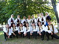 "White Bird" folk dance theatre in Manhush


References
- ^ Чисельність наявного населення України на 1 січня 2022 [Number of Present Population of Ukraine, as of January 1, 2022] (PDF) (in Ukrainian and English). Kyiv: State Statistics Service of Ukraine. Archived (PDF) from the original on 4 July 2022.
- ^ Всесоюзная перепись населения 1989 г. Численность городского населения союзных республик, их территориальных единиц, городских поселений и городских районов по полу
- ^ Engelbrecht, Cora; Triebert, Christiaan (2022-04-21). "Satellite images show what appears to be a growing mass grave near Mariupol". The New York Times. ISSN 0362-4331. Retrieved 2022-04-21.
External links
- Pershotravneve at the Informational portal for the Donetsk Oblast as part of the Ukrainian SSR.
- v
- t
- e
- Amvrosiivka
- Andriivka
- Avdiivka
- Bakhmut
- Bilozerske
- Boikivske
- Chasiv Yar
- Cherkaske
- Chystiakove
- Debaltseve
- Dobropillia
- Dokuchaievsk
- Donetsk
- Druzhkivka
- Horlivka
- Hrodivka
- Illinivka
- Ilovaisk
- Kalchyk
- Kalmiuske
- Khartsyzk
- Khliobodarivka
- Khrestivka
- Komar
- Kostiantynivka
- Kramatorsk
- Kryvorizhzhia
- Kurakhove
- Lyman
- Makiivka
- Manhush
- Marinka
- Mariupol
- Mykolaivka
- Myrne
- Myrnohrad
- Nikolske
- Novoazovsk
- Novodonetske
- Novohrodivka
- Ocheretyne
- Oleksandrivka
- Olhynka
- Pokrovsk
- Sartana
- Selydove
- Shakhove
- Shakhtarsk
- Siversk
- Sloviansk
- Snizhne
- Soledar
- Starobesheve
- Staromlynivka
- Sviatohirsk
- Svitlodarsk
- Toretsk
- Udachne
- Velyka Novosilka
- Volnovakha
- Vuhledar
- Vuhlehirsk
- Yasynuvata
- Yenakiieve
- Zhdanivka
- Zvanivka
- Amvrosiivka
- Avdiivka
- Bakhmut
- Bilozerske
- Bilytske
- Bunhe
- Chasiv Yar
- Chystiakove
- Debaltseve
- Dobropillia
- Dokuchaievsk
- Donetsk
- Druzhkivka
- Hirnyk
- Horlivka
- Ilovaisk
- Kalmiuske
- Khartsyzk
- Khrestivka
- Kostiantynivka
- Kramatorsk
- Krasnohorivka
- Kurakhove
- Lyman
- Makiivka
- Marinka
- Mariupol
- Mospyne
- Mykolaivka
- Myrnohrad
- Novoazovsk
- Novohrodivka
- Pokrovsk
- Rodynske
- Selydove
- Shakhtarsk
- Siversk
- Sloviansk
- Snizhne
- Soledar
- Sviatohirsk
- Svitlodarsk
- Toretsk
- Ukrainsk
- Volnovakha
- Vuhledar
- Vuhlehirsk
- Yasynuvata
- Yenakiieve
- Zalizne
- Zhdanivka
- Zuhres
| Authority control databases |
|
|---|
 | This article about a location in Donetsk Oblast is a stub. You can help Wikipedia by expanding it. |
- v
- t
- e


