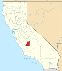
Kings County (Californië)
County in de Verenigde Staten  | |||
|---|---|---|---|
 | |||
| Situering | |||
| Staat | Californië | ||
| Coördinaten | 36°4'12"NB, 119°48'36"WL | ||
| Algemeen | |||
| Oppervlakte | 3.604 km² | ||
| - land | 3.603 km² | ||
| - water | 1 km² | ||
| Inwoners (2000) | 129.461 (36 inw./km²) | ||
| Overig | |||
| FIPS-code | 06031 | ||
| Foto's | |||
 Bevolkingspiramide Kings County | |||
| Statistieken volkstelling Kings County | |||
| |||

Kings County is een county in Californië in de VS. Het werd gevormd in 1893 en bestond uit delen van Tulare County.
Zijn naam kreeg het van de Kings rivier welke ontdekt werd in 1805 door een expeditie en toen Rio de los Santos Reyes (rivier van de heilige koningen) genoemd werd.
Geografie
De county heeft een totale oppervlakte van 3604 km² (1391 mijl²) waarvan 3603 km² (1391 mijl²)land is en 1 km² (0 mijl²) of 0.04%) water is.
Aangrenzende county's
- Kern County - zuiden
- Tulare County - oosten
- Fresno County - noorden, noordwest
- Monterey County - westen
- San Luis Obispo County - zuidwest
Steden en dorpen
- Armona
- Avenal
- Corcoran
- Hanford
- Home Garden
- Kettleman City
- Lemoore
- Lemoore Station
- Stratford
Externe links
- Officiële website van Kings County
- Censusgegevens van Kings County
Californië
Hoofdstad: Sacramento
Regio's: Antelope Valley · Big Sur · Cascade Range · Central Coast · Central Valley · Channel Islands · Coachella Valley · Conejo Valley · Cucamonga Valley · Death Valley · East Bay · East County · Emerald Triangle · Gold Country · Greater Los Angeles · Grote Bekken · Imperial Valley · Inland Empire · Klamath Basin · Lake Tahoe · Los Angeles Basin · Lost Coast · Mojave · Mountain Empire · Noord-Californië · North Bay · North Coast · North County · Oost-Californië · Owens Valley · Oxnard Plain · San Francisco Peninsula · Pomona Valley · Sacramento Valley · San Bernardino Valley · San Diego–Tijuana · San Fernando Valley · San Francisco Bay Area · San Gabriel Valley · San Joaquin Valley · Santa Clara Valley · Santa Clarita Valley · Shasta Cascade · Sierra Nevada · Silicon Valley · South Bay (LA) · South Bay (SD) · South Bay (SF) · South Coast · Southern Border Region · Upstate California · Wine Country · Yosemite · Zuid-Californië
Metropolitane gebieden: Bakersfield · Chico · Fresno · Los Angeles-Long Beach-Glendale · Modesto · Napa · Oakland-Fremont-Hayward · Oxnard-Thousand Oaks-Ventura · Riverside-San Bernardino-Ontario · Sacramento-Roseville · Salinas · San Diego-Carlsbad-San Marcos · San Francisco-San Mateo-Redwood City · San Jose-Sunnyvale-Santa Clara · San Luis Obispo-Paso Robles · Santa Ana-Anaheim-Irvine · Santa Barbara-Santa Maria · Santa Cruz-Watsonville · Santa Rosa-Petaluma · Stockton · Vallejo-Fairfield · Visalia-Porterville · Yuba City
County's: Alameda · Alpine · Amador · Butte · Calaveras · Colusa · Contra Costa · Del Norte · El Dorado · Fresno · Glenn · Humboldt · Imperial · Inyo · Kern · Kings · Lake · Lassen · Los Angeles · Madera · Marin · Mariposa · Mendocino · Merced · Modoc · Mono · Monterey · Napa · Nevada · Orange · Placer · Plumas · Riverside · Sacramento · San Benito · San Bernardino · San Diego · San Francisco · San Joaquin · San Luis Obispo · San Mateo · Santa Barbara · Santa Clara · Santa Cruz · Shasta · Sierra · Siskiyou · Solano · Sonoma · Stanislaus · Sutter · Tehama · Trinity · Tulare · Tuolumne · Ventura · Yolo · Yuba
Portaal Californië


