Aubarède
Gemeente in Frankrijk  | |||
|---|---|---|---|
 | |||
  | |||
| Situering | |||
| Regio | Occitanie | ||
| Departement | Hautes-Pyrénées (65) | ||
| Arrondissement | Tarbes | ||
| Kanton | Les Coteaux | ||
| Coördinaten | 43° 16′ NB, 0° 15′ OL | ||
| Algemeen | |||
| Oppervlakte | 4,85 km² | ||
| Inwoners (1 januari 2021) | 289[1] (60 inw./km²) | ||
| Hoogte | 210 - 426 m | ||
| Overig | |||
| Postcode | 65350 | ||
| INSEE-code | 65044 | ||
| Foto's | |||
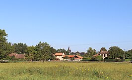 | |||
| Zicht op het dorp | |||
| |||

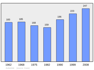
Aubarède is een gemeente in het Franse departement Hautes-Pyrénées (regio Occitanie) en telt 223 inwoners (1999). De plaats maakt deel uit van het arrondissement Tarbes.
Geografie
De oppervlakte van Aubarède bedraagt 4,9 km², de bevolkingsdichtheid is 45,5 inwoners per km².

Demografie
Onderstaande figuur toont het verloop van het inwonertal (bron: INSEE-tellingen).
Externe links
- (fr) Statistische informatie op de website van INSEE
Mediabestanden
Zie de categorie Aubarède van Wikimedia Commons voor mediabestanden over dit onderwerp.
- ↑ Populations légales 2021.


