ボンドークー
ボンドークー Bondoukou | |
|---|---|
| 首府・州都 | |
 1910年のボンドークー | |
  ボンドークー | |
| 北緯8度2分 西経2度48分 / 北緯8.033度 西経2.800度 / 8.033; -2.800 | |
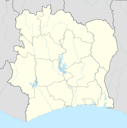
| 国 |  コートジボワール コートジボワール |
| 地方 | ザンザン地方 |
| 州 | ゴントゴ州 |
| 郡 | ボンドークー郡 |
| 政府 | |
| • 市長 | Kone Hiliassou |
| 標高 | 343 m |
| 人口 (2014年)[1] | |
| • 合計 | 117,453人 |
| 等時帯 | UTC+0 (グリニッジ標準時) |
ボンドークー(フランス語:Bondoukou)は、コートジボワール北東部のザンザン地方の首府。 ゴントゴ州の州都でもある。 2014年の人口は約11.7万人。 アビジャンから420km離れている。 [2] ガーナ国境に近い。 A1号線が通り、北のソロバンゴ(英語版)と、東のガーナに分岐する。
歴史
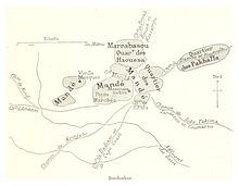
元々ジュラ人(英語版)の交易所が有った。
17世紀初頭、アカン人(英語版)の一派のアブロン族(英語版)が征服すると、すぐにジャーマン王国(英語版)の経済の中心になった。 [3]
1895年9月、サモリ・トゥーレが征服しワスール帝国(英語版)に併合した。
1899年、フランス領西アフリカに併合された。
植民地時代終盤には、近くの州都のロティに人口を奪われ大きな村の水準まで落ち込んでいた。
1964年、州都になり最大の町になった。
1980年、コートジボワール民主党(英語版)(PDCI-RDA)政府に反対する学生によって、全国で初めて中学校のストが起こった。
第1次コートジボワール内戦(英語版)が始まると、政府軍と反乱軍は国を南北に分割した。 ボンドークーは北東部における国際連合コートジボワール活動(ONUCI)の重要拠点になった。 [4]
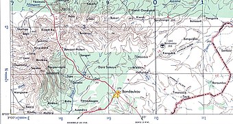
交通
- ソコ空港(英語版)
気候
| ボンドークーの気候 | |||||||||||||
|---|---|---|---|---|---|---|---|---|---|---|---|---|---|
| 月 | 1月 | 2月 | 3月 | 4月 | 5月 | 6月 | 7月 | 8月 | 9月 | 10月 | 11月 | 12月 | 年 |
| 平均最高気温 °C (°F) | 33.7 (92.7) | 35.0 (95) | 34.5 (94.1) | 32.8 (91) | 31.6 (88.9) | 29.5 (85.1) | 27.9 (82.2) | 27.6 (81.7) | 28.7 (83.7) | 30.5 (86.9) | 32.0 (89.6) | 32.2 (90) | 31.3 (88.3) |
| 日平均気温 °C (°F) | 26.4 (79.5) | 28.0 (82.4) | 28.2 (82.8) | 27.5 (81.5) | 26.6 (79.9) | 25.2 (77.4) | 24.3 (75.7) | 24.0 (75.2) | 24.3 (75.7) | 25.3 (77.5) | 26.0 (78.8) | 25.5 (77.9) | 25.9 (78.6) |
| 平均最低気温 °C (°F) | 19.6 (67.3) | 21.6 (70.9) | 22.5 (72.5) | 22.5 (72.5) | 22.2 (72) | 21.3 (70.3) | 20.9 (69.6) | 20.7 (69.3) | 20.7 (69.3) | 20.9 (69.6) | 21.1 (70) | 19.7 (67.5) | 21.1 (70) |
| 降水量 mm (inch) | 7.9 (0.311) | 26.9 (1.059) | 92.3 (3.634) | 123.7 (4.87) | 156.1 (6.146) | 160.2 (6.307) | 96.5 (3.799) | 90.0 (3.543) | 175.1 (6.894) | 130.5 (5.138) | 31.6 (1.244) | 11.1 (0.437) | 1,101.9 (43.382) |
| 平均月間日照時間 | 227.0 | 221.0 | 212.9 | 205.4 | 207.0 | 157.7 | 111.4 | 90.4 | 118.7 | 186.5 | 196.6 | 202.9 | 2,137.5 |
| 出典:NOAA[5] | |||||||||||||
民族対立
1990年代~2000年代、クランゴ人と、ブーナから近年移住したロビ人(英語版)の間で紛争が続いた。 [6] [7] [8]
脚注
- ^ “Côte d'Ivoire”. geohive.com. 2015年12月5日閲覧。
- ^ Conflit foncier dans le nord ivoirien : 8 morts et 21 blessés. Places Bondoukou 424 km NE of capitol. APA : 8/9/2008
- ^ Le royaume Abron de Bondoukou, retrieved 2008-09-10
- ^ Bondoukou, Cote d'Ivoire, reflections of UN Worker, 2008.
- ^ “Bondoukou Climate Normals 1961–1990”. National Oceanic and Atmospheric Administration. 2015年3月8日閲覧。
- ^ Ethnologue code "kzc"
- ^ Ethnic violence flares up in Ivory Coast, IOL News, September 08 2008.
- ^ Côte d’Ivoire – Land dispute. Land dispute leaves 8 dead, 21 injured in northern Côte d’Ivoire[リンク切れ], APA news 8 September 2008
- Muhammad, Akbar. The Samorian Occupation of Bondoukou: An Indigenous View. The International Journal of African Historical Studies, Vol. 10, No. 2 (1977), pp. 242–258.
- Drinking the Word of God. Expressions of Faith and the Search for Well-Being in Two West African Communities. March 18, 2001 - January 20, 2002. Short history and photo gallery, Michigan State University, retrieved 2008-09-10.
- Portions of this article were translated from the French language Wikipedia article fr:Bondoukou, 2008-09-10.
外部リンク
- Bondoukou site (French language)
- 1955 US Military Map of Bondoukou region.+
- MSN Map
典拠管理データベース | |
|---|---|
| 全般 |
|
| 国立図書館 |
|


