Battir
Battir | |
|---|---|
munc | |
| Transkripsi Lainnya | |
| • Arab | بتير |
| • Ejaan lain | Bateer (resmi) |
 Battir | |
| Kegubernuran | Bethlehem |
| Pemerintahan | |
| • Jenis | Munisipalitas |
| • Kepala Munisipalitas | Akram Bader |
| Luas | |
| • Yurisdiksi | 7,419 dunams (74 km2 or 29 sq mi) |
| Populasi (2007)[1] | |
| • Yurisdiksi | 3.967 |
| Arti nama | Bether[2] |
Situs Warisan Dunia UNESCO | |
| Nama resmi | Palestine: Land of Olives and Vines — Cultural Landscape of Southern Jerusalem, Battir |
| Jenis | Kebudayaan |
| Kriteria | iv, v |
| Ditetapkan | 2014 (sesi ke-38) |
| No. referensi | 1492 |
| Partai Negara |  Palestina Palestina |
| Kawasan | Negara-negara Arab |
| Terancam | Sejak 2014 |
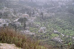
Battir (bahasa Arab: بتير) adalah sebuah desa Palestina di Tepi Barat, 6.4 km dari barat Bethlehem, dan barat daya Yerusalem. Betar Kuno, dinama nama Battir berasal, adalah desa dan benteng Yahudi abad kedua, situs pertempuran akhir pemberontakan Bar Kokhba.
Referensi
Daftar pustaka
- Barron, J. B., ed. (1923). Palestine: Report and General Abstracts of the Census of 1922. Government of Palestine.
- Clermont-Ganneau, Charles Simon (1899). [ARP] Archaeological Researches in Palestine 1873-1874, translated from the French by J. McFarlane. 1. London: Palestine Exploration Fund.
- Conder, Claude Reignier; Kitchener, Herbert H. (1883). The Survey of Western Palestine: Memoirs of the Topography, Orography, Hydrography, and Archaeology. 3. London: Committee of the Palestine Exploration Fund.
- Dauphin, Claudine (1998). La Palestine byzantine, Peuplement et Populations. BAR International Series 726 (dalam bahasa French). III : Catalogue. Oxford: Archeopress. ISBN 0-860549-05-4. Pemeliharaan CS1: Bahasa yang tidak diketahui (link)
- Department of Statistics (1945). Village Statistics, April, 1945. Government of Palestine.
- Guérin, Victor (1869). Description Géographique, Historique et Archéologique de la Palestine. Judee, Vol 1, pt 2, part 1.
- Hadawi, Sami (1970). Village Statistics of 1945: A Classification of Land and Area ownership in Palestine. Palestine Liberation Organization Research Centre.
- Hartmann, M. (1883). "Die Ortschaftenliste des Liwa Jerusalem in dem türkischen Staatskalender für Syrien auf das Jahr 1288 der Flucht (1871)". Zeitschrift des Deutschen Palästina-Vereins. 6: 102–149.
- Hütteroth, Wolf-Dieter; Abdulfattah, Kamal (1977). Historical Geography of Palestine, Transjordan and Southern Syria in the Late 16th Century. Erlanger Geographische Arbeiten, Sonderband 5. Erlangen, Germany: Vorstand der Fränkischen Geographischen Gesellschaft. ISBN 3-920405-41-2.
- Mills, E., ed. (1932). Census of Palestine 1931. Population of Villages, Towns and Administrative Areas. Jerusalem: Government of Palestine.
- Palmer, E. H. (1881). The Survey of Western Palestine: Arabic and English Name Lists Collected During the Survey by Lieutenants Conder and Kitchener, R. E. Transliterated and Explained by E.H. Palmer. Committee of the Palestine Exploration Fund.
- Schick, C. (1896). "Zur Einwohnerzahl des Bezirks Jerusalem". Zeitschrift des Deutschen Palästina-Vereins. 19: 120–127.
- Socin, A. (1879). "Alphabetisches Verzeichniss von Ortschaften des Paschalik Jerusalem". Zeitschrift des Deutschen Palästina-Vereins. 2: 135–163.
Pranala luar
- Welcome To Battir
- Survey of Western Palestine, Map 17: IAA, Wikimedia commons
- Battir Village (Fact Sheet), Applied Research Institute - Jerusalem (ARIJ)
- Battir Village Profile, ARIJ
- Battir Village Area Photo, ARIJ
- The priorities and needs for development in Battir village based on the community and local authorities’ assessment, ARIJ
- www.battir.i8.com
- Battir village photos
- Battir Video
Templat:Kegubernuran Bethlehem
Wikimedia Commons memiliki media mengenai Battir.


