Yaquina Bay Bridge
Bridge in Newport, Oregon
44°37′21″N 124°03′25″W / 44.62257°N 124.05682°W / 44.62257; -124.05682 US 101
Yaquina Bay Bridge No. 01820


The Yaquina Bay Bridge is an arch bridge that spans Yaquina Bay south of Newport, Oregon. It is one of the most recognizable of the U.S. Route 101 bridges designed by Conde McCullough and one of eleven major bridges on the Oregon Coast Highway designed by him.[3] It superseded the last ferry crossing on the highway.
History
Work on the Yaquina Bay Bridge began on August 1, 1934. The bridge opened on September 6, 1936,[1] at a cost of $1,301,016 ($28,570,000 in today's dollars). A total of 220 people worked to pour 30,000 cubic yards (23,000 m3) of concrete and fabricate 3,100 tons of steel. The contractors were the Gilpin Construction Company of Portland, Oregon, and the General Construction Company of Seattle, Washington. The main arch was built in toward the center from the anchorages, using tiebacks to support the arch until it could be closed. The piers are supported by timber pilings driven to a depth of about 70 feet (21 m) below sea level. The project received funding from the Public Works Administration.[4]
Description
The 600-foot (180 m) main span is a semi-through arch, with the roadway penetrating the middle of the arch. It is flanked by identical 350-foot (110 m) steel deck arches, with five concrete deck arches of diminishing size extending to the south landing. The main arch is marked by tall obelisk-like concrete finials on the main piers, with smaller decorative elements marking the ends of the flanking spans.[5][6] The arches are built as box girders. The two-lane road is 27 feet (8.2 m) wide, running inside the arches with two 3.5-foot (1.1 m) sidewalks. The main arch is 246 feet (75 m) above sea level at its crown. Overall length of the bridge is 3,260 feet (990 m), including concrete deck-girder approach spans. The navigable channel measures 400 feet (120 m) wide by 133 feet (41 m) high.[4]
The bridge uses Art Deco and Art Moderne design motifs as well as forms borrowed from Gothic architecture. The Gothic influence is seen in the balustrade, which features small pointed arches, and in the arches of the side span piers. The ends of the bridge are augmented by pedestrian plazas that afford a view of the bridge and provide access to the parks at the landings by stairways. Pedestals were provided for proposed sculptures of seals, but the statues were never executed.
Designation
The Yaquina Bay Bridge was placed on the National Register of Historic Places on August 5, 2005.[2]
Gallery
-
 The main span
 -
 From the roadway
 -
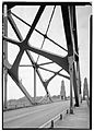 The interior of the bridge
 -
 The base of the bridge
 -
 Base, picnic tables.
 -
 From the west
 -
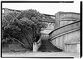 The north staircase
 -
 Looking south; photographer is next to north staircase


See also
 Transport portal
 Engineering portal
 Oregon portal
- List of bridges documented by the Historic American Engineering Record in Oregon
- List of bridges on the National Register of Historic Places in Oregon
- List of bridges on U.S. Route 101 in Oregon
- National Register of Historic Places listings in Lincoln County, Oregon


References
- ^ a b "Span at Newport Open For Traffic" (September 6, 1936). The Sunday Oregonian (Portland), pp. 1–2.
- ^ a b "National Register Information System". National Register of Historic Places. National Park Service. July 9, 2010.
- ^ Smith, Dwight A.; Norman, James B.; Dykman, Pieter T. (1989). Historic Highway Bridges of Oregon. Oregon Historical Society Press. p. 111. ISBN 0-87595-205-4.
- ^ a b Hadlow, Robert W. (June 30, 2004). "Yaquina Bay Bridge No. 012820". National Park Service. Retrieved 29 August 2012.
- ^ Hadlow, Robert W. (2001). Elegant Arches, Soaring Spans: C. B. McCullough, Oregon's Master Bridge Builder. Oregon State University Press. p. 139. ISBN 0-87071-534-8.
- ^ "Oregon Coastal Highway Bridges". Oregon Department of Transportation. Retrieved 2006-11-10.
External links
Wikimedia Commons has media related to Yaquina Bay Bridge.
- Historic American Engineering Record (HAER) No. OR-44, "Yaquina Bay Bridge, Spans Yaquina Bay at Oregon Coast Highway, Newport, Lincoln County, OR", 26 photos, 7 data pages, 3 photo caption pages
- v
- t
- e
- List of U.S. National Historic Landmarks by state:
- Alabama
- Alaska
- Arizona
- Arkansas
- California
- Colorado
- Connecticut
- Delaware
- Florida
- Georgia
- Hawaii
- Idaho
- Illinois
- Indiana
- Iowa
- Kansas
- Kentucky
- Louisiana
- Maine
- Maryland
- Massachusetts
- Michigan
- Minnesota
- Mississippi
- Missouri
- Montana
- Nebraska
- Nevada
- New Hampshire
- New Jersey
- New Mexico
- New York
- North Carolina
- North Dakota
- Ohio
- Oklahoma
- Oregon
- Pennsylvania
- Rhode Island
- South Carolina
- South Dakota
- Tennessee
- Texas
- Utah
- Vermont
- Virginia
- Washington
- West Virginia
- Wisconsin
- Wyoming
 National Register of Historic Places portal
 Category


