Wisconsin statistical areas
Wisconsin statistical areas
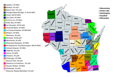
The U.S. State of Wisconsin currently has 36 statistical areas that have been delineated by the Office of Management and Budget (OMB). On March 6, 2020, the OMB delineated nine combined statistical areas, 15 metropolitan statistical areas, and 12 micropolitan statistical areas in Wisconsin.[1]
Statistical areas
The Office of Management and Budget (OMB) has designated more than 1,000 statistical areas for the United States and Puerto Rico.[2] These statistical areas are important geographic delineations of population clusters used by the OMB, the United States Census Bureau, planning organizations, and federal, state, and local government entities.
The OMB defines a core-based statistical area (commonly referred to as a CBSA) as "a statistical geographic entity consisting of the county or counties (or county-equivalents) associated with at least one core[a] of at least 10,000 population, plus adjacent counties having a high degree of social and economic integration with the core as measured through commuting ties with the counties containing the core."[2] The OMB further divides core-based statistical areas into metropolitan statistical areas (MSAs) that have "a population of at least 50,000" and micropolitan statistical areas (μSAs) that have "a population of at least 10,000, but less than 50,000."[2]
The OMB defines a combined statistical area (CSA) as "a geographic entity consisting of two or more adjacent core-based statistical areas with employment interchange measures[b] of at least 15%."[2] The primary statistical areas (PSAs) include all combined statistical areas and any core-based statistical area that is not a constituent of a combined statistical area.
Table
The table below describes the 36 United States statistical areas and 72 counties of the State of Wisconsin with the following information:[3]
- The combined statistical area (CSA) as designated by the OMB.[1]
- The CSA population according to 2019 US Census Bureau population estimates.[4]
- The core based statistical area (CBSA)[2] as designated by the OMB.[1]
- The CBSA population according to 2019 US Census Bureau population estimates [4]
- The county name
- The county population according to 2019 US Census Bureau population estimates [4]
- The Metropolitan Division name, if applicable[1]
- The Metropolitan Division population according to 2019 US Census Bureau population estimates [4]
| Combined Statistical Area | 2019 Population | Core Based Statistical Area | 2019 Population | County | 2019 Population | Metropolitan Division | 2019 Population |
|---|---|---|---|---|---|---|---|
| Milwaukee-Racine-Waukesha, WI CSA | 2,047,966 | Milwaukee-Waukesha, WI MSA | 1,575,179 | Milwaukee County, Wisconsin | 945,726 | none | |
| Waukesha County, Wisconsin | 404,198 | ||||||
| Washington County, Wisconsin | 136,034 | ||||||
| Ozaukee County, Wisconsin | 89,221 | ||||||
| Racine, WI MSA | 196,311 | Racine County, Wisconsin | 196,311 | ||||
| Whitewater, WI μSA | 103,868 | Walworth County, Wisconsin | 103,868 | ||||
| Beaver Dam, WI μSA | 87,839 | Dodge County, Wisconsin | 88,839 | ||||
| Watertown-Fort Atkinson, WI μSA | 84,769 | Jefferson County, Wisconsin | 84,769 | ||||
| Madison-Janesville-Beloit, WI CSA | 892,661 | Madison, WI MSA | 664,865 | Dane County, Wisconsin | 546,695 | ||
| Columbia County, Wisconsin | 57,532 | ||||||
| Green County, Wisconsin | 36,960 | ||||||
| Iowa County, Wisconsin | 23,678 | ||||||
| Janesville-Beloit, WI MSA | 163,354 | Rock County, Wisconsin | 163,354 | ||||
| Baraboo, WI μSA | 64,442 | Sauk County, Wisconsin | 64,442 | ||||
| Appleton-Oshkosh-Neenah, WI CSA | 409,881 | Appleton, Wisconsin metropolitan area | 237,974 | Outagamie County, Wisconsin | 187,885 | ||
| Calumet County, Wisconsin | 50,089 | ||||||
| Oshkosh-Neenah, WI MSA | 171,907 | Winnebago County, Wisconsin | 171,907 | ||||
| Green Bay-Shawano, WI CSA | 368,361 | Green Bay, WI MSA | 322,906 | Brown County, Wisconsin | 264,542 | ||
| Oconto County, Wisconsin | 37,930 | ||||||
| Kewaunee County, Wisconsin | 20,434 | ||||||
| Shawano, WI μSA | 45,455 | Shawano County, Wisconsin | 40,899 | ||||
| Menominee County, Wisconsin | 4,556 | ||||||
| Wausau-Stevens Point-Wisconsin Rapids, WI CSA | 307,056 | Wausau-Weston, WI MSA | 163,285 | Marathon County, Wisconsin | 135,692 | ||
| Lincoln County, Wisconsin | 27,593 | ||||||
| Wisconsin Rapids-Marshfield, WI μSA | 72,999 | Wood County, Wisconsin | 72,999 | ||||
| Stevens Point, WI μSA | 70,772 | Portage County, Wisconsin | 70,772 | ||||
| Eau Claire-Menomonie, WI CSA | 214,672 | Eau Claire, WI MSA | 169,304 | Eau Claire County, Wisconsin | 104,646 | ||
| Chippewa County, Wisconsin | 64,658 | ||||||
| Menomonie, WI μSA | 45,368 | Dunn County, Wisconsin | 45,368 | ||||
| Chicago-Naperville, IL-IN-WI CSA | 9,825,325 169,561 | Chicago-Naperville-Joliet, IL-IN-WI MSA | 9,458,539 169,561 | Cook County, Illinois | 5,150,233 | Chicago-Naperville-Evanston, IL MD | 7,122,725 |
| DuPage County, Illinois | 922,921 | ||||||
| Will County, Illinois | 690,743 | ||||||
| McHenry County, Illinois | 307,774 | ||||||
| Grundy County, Illinois | 51,054 | ||||||
| Lake County, Illinois | 696,535 | Lake County-Kenosha County, IL-WI MD | 866,096 169,561 | ||||
| Kenosha County, Wisconsin | 169,561 | ||||||
| Kane County, Illinois | 532,403 | Elgin, IL MD | 766,290 | ||||
| Kendall County, Illinois | 128,990 | ||||||
| DeKalb County, Illinois | 104,897 | ||||||
| Lake County, Indiana | 485,493 | Gary, IN MD | 703,428 | ||||
| Porter County, Indiana | 170,389 | ||||||
| Jasper County, Indiana | 33,562 | ||||||
| Newton County, Indiana | 13,984 | ||||||
| Ottawa, IL μSA | 147,036 | LaSalle County, Illinois | 108,669 | none | |||
| Bureau County, Illinois | 32,628 | ||||||
| Putnam County, Illinois | 5,739 | ||||||
| Michigan City-La Porte, IN MSA | 109,888 | LaPorte County, Indiana | 109,888 | ||||
| Kankakee, IL MSA | 109,862 | Kankakee County, Illinois | 109,862 | ||||
| Minneapolis-St. Paul, MN-WI CSA | 4,027,861 133,441 | Minneapolis-St. Paul-Bloomington, MN-WI MSA | 3,640,043 133,441 | Hennepin County, Minnesota | 1,265,843 | ||
| Ramsey County, Minnesota | 550,321 | ||||||
| Dakota County, Minnesota | 429,021 | ||||||
| Anoka County, Minnesota | 356,921 | ||||||
| Washington County, Minnesota | 262,440 | ||||||
| Scott County, Minnesota | 149,013 | ||||||
| Wright County, Minnesota | 138,377 | ||||||
| Carver County, Minnesota | 105,089 | ||||||
| Sherburne County, Minnesota | 97,238 | ||||||
| St. Croix County, Wisconsin | 90,687 | ||||||
| Chisago County, Minnesota | 56,579 | ||||||
| Pierce County, Wisconsin | 42,754 | ||||||
| Isanti County, Minnesota | 40,596 | ||||||
| Le Sueur County, Minnesota | 28,887 | ||||||
| Mille Lacs County, Minnesota | 26,277 | ||||||
| St. Cloud, MN MSA | 201,964 | Stearns County, Minnesota | 161,075 | ||||
| Benton County, Minnesota | 40,889 | ||||||
| Faribault-Northfield, MN μSA | 66,972 | Rice County, Minnesota | 66,972 | ||||
| Red Wing, MN μSA | 46,340 | Goodhue County, Minnesota | 46,340 | ||||
| Owatonna, MN μSA | 36,649 | Steele County, Minnesota | 36,649 | ||||
| Hutchinson, MN μSA | 35,893 | McLeod County, Minnesota | 35,893 | ||||
| none | La Crosse, WI-MN MSA | 136,616 118,016 | La Crosse County, Wisconsin | 118,016 | |||
| Houston County, Minnesota | 18,600 | ||||||
| Sheboygan, WI MSA | 115,340 | Sheboygan County, Wisconsin | 115,340 | ||||
| Fond du Lac, WI MSA | 103,403 | Fond du Lac County, Wisconsin | 103,403 | ||||
| Manitowoc, WI μSA | 78,981 | Manitowoc County, Wisconsin | 78,981 | ||||
| Platteville, WI μSA | 51,439 | Grant County, Wisconsin | 51,439 | ||||
| Marinette-Iron Mountain, WI-MI CSA | 92,664 44,645 | Marinette, WI-MI μSA | 63,130 40,350 | Marinette County, Wisconsin | 40,350 | ||
| Menominee County, Michigan | 22,780 | ||||||
| Iron Mountain, MI-WI μSA | 29,534 4,295 | Dickinson County, Michigan | 25,239 | ||||
| Florence County, Wisconsin | 4,295 | ||||||
| none | Duluth, MN-WI MSA | 288,732 43,150 | St. Louis County, Minnesota | 199,070 | |||
| Douglas County, Wisconsin | 43,150 | ||||||
| Carlton County, Minnesota | 35,871 | ||||||
| Lake County, Minnesota | 10,641 | ||||||
| none | Waupaca County, Wisconsin | 50,990 | |||||
| Monroe County, Wisconsin | 46,253 | ||||||
| Barron County, Wisconsin | 45,244 | ||||||
| Polk County, Wisconsin | 43,783 | ||||||
| Oneida County, Wisconsin | 35,595 | ||||||
| Clark County, Wisconsin | 34,774 | ||||||
| Vernon County, Wisconsin | 30,822 | ||||||
| Trempealeau County, Wisconsin | 29,649 | ||||||
| Door County, Wisconsin | 27,668 | ||||||
| Juneau County, Wisconsin | 26,687 | ||||||
| Waushara County, Wisconsin | 24,443 | ||||||
| Vilas County, Wisconsin | 22,195 | ||||||
| Jackson County, Wisconsin | 20,643 | ||||||
| Taylor County, Wisconsin | 20,343 | ||||||
| Adams County, Wisconsin | 20,220 | ||||||
| Langlade County, Wisconsin | 19,189 | ||||||
| Green Lake County, Wisconsin | 18,913 | ||||||
| Richland County, Wisconsin | 17,252 | ||||||
| Lafayette County, Wisconsin | 16,665 | ||||||
| Sawyer County, Wisconsin | 16,558 | ||||||
| Crawford County, Wisconsin | 16,131 | ||||||
| Washburn County, Wisconsin | 15,720 | ||||||
| Marquette County, Wisconsin | 15,574 | ||||||
| Ashland County, Wisconsin | 15,562 | ||||||
| Burnett County, Wisconsin | 15,414 | ||||||
| Bayfield County, Wisconsin | 15,036 | ||||||
| Rusk County, Wisconsin | 14,178 | ||||||
| Price County, Wisconsin | 13,351 | ||||||
| Buffalo County, Wisconsin | 13,031 | ||||||
| Forest County, Wisconsin | 9,004 | ||||||
| Pepin County, Wisconsin | 7,287 | ||||||
| Iron County, Wisconsin | 5,687 | ||||||
| State of Wisconsin | 5,822,434 | ||||||
See also
 Geography portal
 United States portal
 Wisconsin portal


Notes
- ^ The OMB defines a core as "a densely settled concentration of population, comprising an Urban Area (of 10,000 or more population) delineated by the Census Bureau, around which a core-based statistical area is delineated."[2]
- ^ The OMB defines the employment interchange measure as "the sum of the percentage of workers living in the smaller entity who work in the larger entity plus the percentage of employment in the smaller entity that is accounted for by workers who reside in the larger entity."[2]
References
- ^ a b c d e Revised Delineations of Metropolitan Statistical Areas, Micropolitan Statistical Areas, and Combined Statistical Areas, and Guidance on Uses of the Delineations of These Areas (March 6, 2020). "0MB BULLETIN NO. 20-01" (PDF). Office of Management and Budget. Retrieved December 15, 2021.
{{cite web}}: CS1 maint: multiple names: authors list (link) - ^ a b c d e f g "2020 Standards for Delineating Core Based Statistical Areas". Office of Management and Budget. July 16, 2021. Retrieved December 15, 2021.
- ^ An out-of-state area and its population are displayed in green. An area that extends into more than one state is displayed in teal. A teal population number over a black population number show the total population versus the in-state population.
- ^ a b c d "Annual Estimates of the Resident Population for Counties in the United States: April 1, 2010 to July 1, 2019". United States Census Bureau, Population Division. April 2020. Retrieved April 9, 2020.
External links
Wisconsin at Wikipedia's sister projects
 Media from Commons
 News from Wikinews
 Quotations from Wikiquote
 Travel information from Wikivoyage
- Office of Management and Budget
- United States Census Bureau
- v
- t
- e
Madison (capital)
- Outline
- Agriculture
- Climate change
- Geography
- Governors
- Delegations
- History
- People
- Sports
- Symbols
- Tourist attractions
- Apostle Islands
- Central Plain
- Chippewa Valley
- Door Peninsula
- Driftless Area
- Eastern Ridges and Lowlands
- Fox River Valley
- Great River Road
- Lake Superior Lowland
- Northern Highland
- Western Upland
(pop. over 500,000)
(pop. over 50,000)
(pop. 15,000 to 50,000)
- Beaver Dam
- Beloit
- Brookfield
- Cudahy
- De Pere
- Fitchburg
- Fond du Lac
- Franklin
- Greenfield
- Hartford
- Hudson
- Kaukauna
- Manitowoc
- Marshfield
- Menasha
- Menomonie
- Mequon
- Middleton
- Muskego
- Neenah
- New Berlin
- Oak Creek
- Oconomowoc
- Onalaska
- River Falls
- Sheboygan
- South Milwaukee
- Stevens Point
- Sun Prairie
- Superior
- Watertown
- Wausau
- Wauwatosa
- West Bend
- Wisconsin Rapids
(pop. over 15,000)
- Adams
- Ashland
- Barron
- Bayfield
- Brown
- Buffalo
- Burnett
- Calumet
- Chippewa
- Clark
- Columbia
- Crawford
- Dane
- Dodge
- Door
- Douglas
- Dunn
- Eau Claire
- Florence
- Fond du Lac
- Forest
- Grant
- Green
- Green Lake
- Iowa
- Iron
- Jackson
- Jefferson
- Juneau
- Kenosha
- Kewaunee
- La Crosse
- Lafayette
- Langlade
- Lincoln
- Manitowoc
- Marathon
- Marinette
- Marquette
- Menominee
- Milwaukee
- Monroe
- Oconto
- Oneida
- Outagamie
- Ozaukee
- Pepin
- Pierce
- Polk
- Portage
- Price
- Racine
- Richland
- Rock
- Rusk
- Sauk
- Sawyer
- Shawano
- Sheboygan
- St. Croix
- Taylor
- Trempealeau
- Vernon
- Vilas
- Walworth
- Washburn
- Washington
- Waukesha
- Waupaca
- Waushara
- Winnebago
- Wood
 Wisconsin portal
44°37′27″N 89°59′39″W / 44.6243°N 89.9941°W / 44.6243; -89.9941 (State of Wisconsin)


