Vers-Pont-du-Gard
Commune in Occitania, France

Coat of arms
Location of Vers-Pont-du-Gard

(2020–2026) Olivier Sauzet[1]
1
(2021)[2]
30346 /30210
(avg. 52 m or 171 ft)
Vers-Pont-du-Gard (French pronunciation: [vɛʁs pɔ̃ dy ɡaʁ]; Vèrs in Occitan) is a commune in the Gard department in southern France.
The Pont du Gard is located on the territory of the commune.
Gallery
-
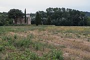 Chapelle Saint-Pierre
 -
 Ancient Roman aqueduct.


Population
| Year | Pop. | ±% |
|---|---|---|
| 1962 | 603 | — |
| 1968 | 644 | +6.8% |
| 1975 | 739 | +14.8% |
| 1982 | 924 | +25.0% |
| 1990 | 1,110 | +20.1% |
| 1999 | 1,322 | +19.1% |
| 2008 | 1,653 | +25.0% |
International relations
Vers-Pont-du-Gard is twinned with:
- Santa Vittoria d'Alba, Italy
- Palézieux, Switzerland
See also
References
- ^ "Répertoire national des élus: les maires" (in French). data.gouv.fr, Plateforme ouverte des données publiques françaises. 13 September 2022.
- ^ "Populations légales 2021". The National Institute of Statistics and Economic Studies. 28 December 2023.
External links
Wikimedia Commons has media related to Vers-Pont-du-Gard.
- Website of Vers-Pont-du-Gard
- Webpage about Vers-Pont-du-Gard
- v
- t
- e
 Communes of the Gard department
- Aigaliers
- Aigremont
- Aigues-Mortes
- Aigues-Vives
- Aiguèze
- Aimargues
- Alèssubpr
- Allègre-les-Fumades
- Alzon
- Anduze
- Les Angles
- Aramon
- Argilliers
- Arpaillargues-et-Aureillac
- Arphy
- Arre
- Arrigas
- Aspères
- Aubais
- Aubord
- Aubussargues
- Aujac
- Aujargues
- Aulas
- Aumessas
- Avèze
- Bagard
- Bagnols-sur-Cèze
- Barjac
- Baron
- La Bastide-d'Engras
- Beaucaire
- Beauvoisin
- Bellegarde
- Belvézet
- Bernis
- Bessèges
- Bez-et-Esparon
- Bezouce
- Blandas
- Blauzac
- Boisset-et-Gaujac
- Boissières
- Bonnevaux
- Bordezac
- Boucoiran-et-Nozières
- Bouillargues
- Bouquet
- Bourdic
- Bragassargues
- Branoux-les-Taillades
- Bréau-Mars
- Brignon
- Brouzet-lès-Alès
- Brouzet-lès-Quissac
- La Bruguière
- Cabrières
- La Cadière-et-Cambo
- Le Cailar
- Caissargues
- La Calmette
- Calvisson
- Campestre-et-Luc
- Canaules-et-Argentières
- Cannes-et-Clairan
- La Capelle-et-Masmolène
- Cardet
- Carnas
- Carsan
- Cassagnoles
- Castelnau-Valence
- Castillon-du-Gard
- Causse-Bégon
- Caveirac
- Cavillargues
- Cendras
- Chambon
- Chamborigaud
- Chusclan
- Clarensac
- Codognan
- Codolet
- Collias
- Collorgues
- Colognac
- Combas
- Comps
- Concoules
- Congénies
- Connaux
- Conqueyrac
- Corbès
- Corconne
- Cornillon
- Courry
- Crespian
- Cros
- Cruviers-Lascours
- Deaux
- Dions
- Domazan
- Domessargues
- Dourbies
- Durfort-et-Saint-Martin-de-Sossenac
- Estézargues
- L'Estréchure
- Euzet
- Flaux
- Foissac
- Fons
- Fons-sur-Lussan
- Fontanès
- Fontarèches
- Fournès
- Fourques
- Fressac
- Gagnières
- Gailhan
- Gajan
- Gallargues-le-Montueux
- Le Garn
- Garons
- Garrigues-Sainte-Eulalie
- Gaujac
- Générac
- Générargues
- Génolhac
- Goudargues
- La Grand-Combe
- Le Grau-du-Roi
- Issirac
- Jonquières-Saint-Vincent
- Junas
- Lamelouze
- Langlade
- Lanuéjols
- Lasalle
- Laudun-l'Ardoise
- Laval-Pradel
- Laval-Saint-Roman
- Lecques
- Lédenon
- Lédignan
- Lézan
- Liouc
- Lirac
- Logrian-Florian
- Lussan
- Les Mages
- Malons-et-Elze
- Mandagout
- Manduel
- Marguerittes
- Martignargues
- Le Martinet
- Maruéjols-lès-Gardon
- Massanes
- Massillargues-Attuech
- Mauressargues
- Méjannes-le-Clap
- Méjannes-lès-Alès
- Meynes
- Meyrannes
- Mialet
- Milhaud
- Molières-Cavaillac
- Molières-sur-Cèze
- Monoblet
- Mons
- Montagnac
- Montaren-et-Saint-Médiers
- Montclus
- Montdardier
- Monteils
- Montfaucon
- Montfrin
- Montignargues
- Montmirat
- Montpezat
- Moulézan
- Moussac
- Mus
- Nages-et-Solorgues
- Navacelles
- Ners
- Nîmespref
- Orsan
- Orthoux-Sérignac-Quilhan
- Parignargues
- Peyremale
- Peyrolles
- Le Pin
- Les Plans
- Les Plantiers
- Pommiers
- Pompignan
- Ponteils-et-Brésis
- Pont-Saint-Esprit
- Portes
- Potelières
- Pougnadoresse
- Poulx
- Pouzilhac
- Puechredon
- Pujaut
- Quissac
- Redessan
- Remoulins
- Revens
- Ribaute-les-Tavernes
- Rivières
- Robiac-Rochessadoule
- Rochefort-du-Gard
- Rochegude
- Rodilhan
- Rogues
- Roquedur
- Roquemaure
- La Roque-sur-Cèze
- Rousson
- La Rouvière
- Sabran
- Saint-Alexandre
- Saint-Ambroix
- Saint-André-de-Majencoules
- Saint-André-de-Roquepertuis
- Saint-André-de-Valborgne
- Saint-André-d'Olérargues
- Saint-Bauzély
- Saint-Bénézet
- Saint-Bonnet-de-Salendrinque
- Saint-Bonnet-du-Gard
- Saint-Brès
- Saint-Bresson
- Saint-Césaire-de-Gauzignan
- Saint-Chaptes
- Saint-Christol-de-Rodières
- Saint-Christol-lès-Alès
- Saint-Clément
- Saint-Côme-et-Maruéjols
- Saint-Denis
- Saint-Dézéry
- Saint-Dionisy
- Sainte-Anastasie
- Sainte-Cécile-d'Andorge
- Sainte-Croix-de-Caderle
- Saint-Étienne-de-l'Olm
- Saint-Étienne-des-Sorts
- Saint-Félix-de-Pallières
- Saint-Florent-sur-Auzonnet
- Saint-Geniès-de-Comolas
- Saint-Geniès-de-Malgoirès
- Saint-Gervais
- Saint-Gervasy
- Saint-Gilles
- Saint-Hilaire-de-Brethmas
- Saint-Hilaire-d'Ozilhan
- Saint-Hippolyte-de-Caton
- Saint-Hippolyte-de-Montaigu
- Saint-Hippolyte-du-Fort
- Saint-Jean-de-Ceyrargues
- Saint-Jean-de-Crieulon
- Saint-Jean-de-Maruéjols-et-Avéjan
- Saint-Jean-de-Serres
- Saint-Jean-de-Valériscle
- Saint-Jean-du-Gard
- Saint-Jean-du-Pin
- Saint-Julien-de-Cassagnas
- Saint-Julien-de-la-Nef
- Saint-Julien-de-Peyrolas
- Saint-Julien-les-Rosiers
- Saint-Just-et-Vacquières
- Saint-Laurent-d'Aigouze
- Saint-Laurent-de-Carnols
- Saint-Laurent-des-Arbres
- Saint-Laurent-la-Vernède
- Saint-Laurent-le-Minier
- Saint-Mamert-du-Gard
- Saint-Marcel-de-Careiret
- Saint-Martial
- Saint-Martin-de-Valgalgues
- Saint-Maurice-de-Cazevieille
- Saint-Maximin
- Saint-Michel-d'Euzet
- Saint-Nazaire
- Saint-Nazaire-des-Gardies
- Saint-Paulet-de-Caisson
- Saint-Paul-la-Coste
- Saint-Paul-les-Fonts
- Saint-Pons-la-Calm
- Saint-Privat-de-Champclos
- Saint-Privat-des-Vieux
- Saint-Quentin-la-Poterie
- Saint-Roman-de-Codières
- Saint-Sauveur-Camprieu
- Saint-Sébastien-d'Aigrefeuille
- Saint-Siffret
- Saint-Théodorit
- Saint-Victor-de-Malcap
- Saint-Victor-des-Oules
- Saint-Victor-la-Coste
- Salazac
- Salindres
- Salinelles
- Les Salles-du-Gardon
- Sanilhac-Sagriès
- Sardan
- Saumane
- Sauve
- Sauveterre
- Sauzet
- Savignargues
- Saze
- Sénéchas
- Sernhac
- Servas
- Serviers-et-Labaume
- Seynes
- Sommières
- Soudorgues
- Soustelle
- Souvignargues
- Sumène
- Tavel
- Tharaux
- Théziers
- Thoiras
- Tornac
- Tresques
- Trèves
- Uchaud
- Uzès
- Vabres
- Val-d'Aigoual
- Vallabrègues
- Vallabrix
- Vallérargues
- Valliguières
- Vauvert
- Vénéjan
- Verfeuil
- Vergèze
- La Vernarède
- Vers-Pont-du-Gard
- Vestric-et-Candiac
- Vézénobres
- Vic-le-Fesq
- Le Vigansubpr
- Villeneuve-lès-Avignon
- Villevieille
- Vissec
- pref: prefecture
- subpr: subprefecture
Authority control databases | |
|---|---|
| International |
|
| National |
|
 | This Gard geographical article is a stub. You can help Wikipedia by expanding it. |
- v
- t
- e


