Vairagad Fort
Ancient Indian fort
the public
Vairagad is a small fort situated in the Gadchiroli district of Maharashtra, India, at the confluence of rivers Khobragadhi and Satnalas. The small dusty village of same name is adjacent to the fort. The fort is situated 180 km from Nagpur and 80 km from Chandrapur.
History
This village is supposed to have been established in Dvapara Yuga by a king named Vairacan (Son from a moon family). The city was ruled by the Mana chiefs, who about the 9th century fell to the Gonds. The Gonds ruled it along with Garbori and Rajgad. Vairagad once possessed diamond mines and are referred in the Ain-i-Akbari of Abul Fazal. On a hill at the foot were supposed to be a mine, now an old Idgah, and 108 Musalman tombs which appear to be of those soldiers killed in the battle when Ahmad Shah Bahamani of Bahmani Sultanate raided Vairagad around 1422. In 1925 the fort was declared as protected monument [1]
Places to visit
The fortress lies north of the village spread over a 10-acre (4.0 ha) area. There are three gates at the entrance of the fort. A river moat (Khandak) nearly 15 to 20 feet (5 to 6 m) deep runs around the fort. There are many wells inside the fort. The step well with two arches, still containing water, is in a ruined state. there are two rectangular wells with large stone coverings. Presently the Archeology dept artment has taken up work of reconstruction of the main entrance. Outside the fort proper is the tomb of the Gond Prince Durga Sah and a grave of unknown English Girl who is believed to be the daughter of a British commandant of the garrison between 1818 and 1830.[2]
About a mile from the fort stands a small temple of Bhandareshwar similar in style to the Markandeya Temple.
See also
- List of forts in Maharashtra
- Gadchiroli
Gallery
-
 Main entrance gate
 -
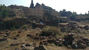 Ruins inside the fort
 -
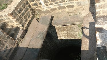 Rectangular well
 -
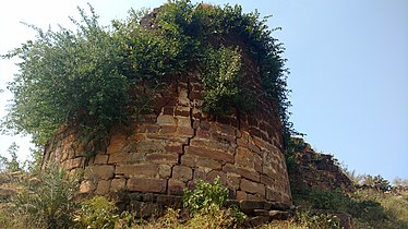 Bastion


References
- v
- t
- e
Forts in Maharashtra
- Ahmednagar Fort
- Bahadurgad
- Bhairavgad
- Bitangad
- Harishchandragad
- Kaladgad
- Kharda
- Kunjargad
- Madan Fort
- Manjarsumbha fort
- Pabargad
- Patta Fort
- Ratangad
- Amner Fort
- Gawilghur
- Chandrapur Fort
- Ballarpur Fort
- Bhadravati Fort
- Manikgad
- Aavandhagad
- Achala Fort
- Ahivant Fort
- Alang
- Anjaneri
- Ankai Fort
- Bahulagad
- Bhaskargad
- Chandwad
- Chauler Fort
- Dermal
- Dhodap
- Hargad
- Harihar fort
- Hatgad
- Indrai
- Kanchangad
- Kanhergad
- Kavnai fort
- Kulang
- Madangad
- Malegaon
- Mangi-Tungi
- Moragad
- Mulher
- Nhavigad
- Rajdher fort
- Ramsej
- Salher
- Salota
- Saptashrungi
- Tankai fort
- Tringalwadi
- Waghera
- Anghaai Fort
- Bhorgiri Fort
- Chawand
- Dhakoba
- Ghangad
- Hadsar Fort
- Induri Fort
- Jivdhan
- Kailasgad
- Kawla
- Korigad/Koraigad
- Lohagad
- Malhargad
- Manaranjan
- Mangalgad
- Morgiri Fort
- Narayangad
- Nimgiri
- Purandar
- Rajgad
- Rajmachi
- Rayri Fort
- Rohida
- Sangram Durg
- Sindola Fort
- Shaniwar Wada
- Shivneri
- Shrivardhan
- Sinhagad
- Tikona
- Torna
- Tung
- Vajragad Fort
- Visapur
- Agarkot
- Avchitgad
- Bhimashankar Fort
- Birwadi
- Chambhargad
- Chandragad
- Dhak Bahiri
- Dronagiri
- Gadad Bahiri
- Ghangad
- Ghosalgad
- Irshalgad
- Karnala
- Khaderi
- Khanderi
- Kondhawi Fort
- Korlai
- Kothaligad Peb fort
- Kulaba
- Kurdugad
- Lingana
- Maangad
- Madgad
- Malanggad
- Mangalgad (Kangori)
- Manikgad
- Mirgad
- Mrugagad
- Murud-Janjira
- Padargad
- Padmadurg/ Kasa Fort
- Prabalgad
- Raigad
- Ratnagad
- Revdanda
- Sagargad
- Samrajgad
- Sankshi Fort
- Sarasgad
- Sarjekot
- Songad
- Songiri Fort
- Sudhagad
- Surgad
- Talagad
- Underi
- Vikatgad Peb fort
- Aambolgad
- Anjanwel
- Bankot
- Gowalkot
- Jaigad
- Kanakdurg
- Mahipatgad
- Mandangad
- Prachitgad
- Prunagad
- Rasalgad
- Ratnagiri (Ratnadurg)
- Sumargad
- Suvarnadurg
- Yashwantgad
- Ajinkyatara
- Bhairavgad
- Bhushangad
- Chandan-Vandan
- Dategad
- Gunavantgad
- Jangali Jayagad
- Kalyangad
- Kamalgad
- Kenjalgad
- Mahimangad
- Pandavgad
- Prachitgad
- Pratapgad
- Sajjangad
- Santoshgad
- Vairatgad
- Vardhangad
- Varugad
- Vasantgad
- Vasota
- Aasavgad
- Bharatgad
- Rajkot Fort
- Sanrjekot
- Sindhudurg
- Vijaydurg
- Aasawa
- Arnala
- Asherigad
- Ballalgad
- Balwantgad
- Belapur Fort
- Bhairavgad
- Bhandargad
- Bhavanigad
- Bhupatgad
- Chanderigad
- Dahanugad
- Daulatmandal
- Dharavi
- Durgadi Fort
- Gambhirgad
- Ghodbunder Fort
- Gorakhgad
- Gotara
- Jivdhaanigad
- Kamandurg
- Kelwegad
- Kohojgad
- Mahuli
- Malang gad
- Palasgad
- Pankot
- Tahuli
- Shirgav Fort
- Jalna Fort(Mastgarh)
- Rohilagarh
- Jafrabad Qila


