Slochteren
Village and former municipality in Groningen, Netherlands

Flag

Coat of arms

Location in Groningen
(2021)[1]
9621[1]
Slochteren (Dutch pronunciation: [ˈslɔxtərə(n)] ⓘ) is a village and former municipality with a population of 15,546 in the province of Groningen in the northeast of the Netherlands. On 1 January 2018, Slochteren merged with Hoogezand-Sappemeer and Menterwolde, forming the municipality Midden-Groningen.
The former municipality can be characterized as a chain of small villages dividing a mostly agricultural landscape. Having an agricultural background for at least a thousand years, the community houses for the most part commuters to nearby towns like Hoogezand, Groningen and Delfzijl. The mansion Fraeylemaborg (a small 'castle', the oldest parts of which are dated in the Middle Ages) is located in Slochteren.
Geography
The population centres in the former municipality are:
- Denemarken
- Froombosch
- Harkstede
- Hellum
- Kolham
- Lageland
- Luddeweer
- Overschild
- Schaaphok
- Scharmer
- Schildwolde
- Siddeburen
- Slochteren
- Steendam
- Tjuchem
- Woudbloem

Topographic map of the municipality of Slochteren, June 2015
Natural gas field
Slochteren is in the center of the giant Groningen gas field, discovered in 1959, ensuring the position of the Netherlands as a major energy exporting country. The estimated gas reserves in 2009 was 2,700 km3 (650 cu mi).[3]
Gallery
-
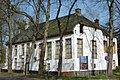
 Protestant Church
 -
 Former courthouse of Slochteren
 -
 Town hall
 -
 Former post office


References
External links
 Media related to Slochteren at Wikimedia Commons
Places adjacent to Slochteren | ||||||||||||||||
|---|---|---|---|---|---|---|---|---|---|---|---|---|---|---|---|---|
| ||||||||||||||||


- v
- t
- e
Populated places in the municipality of Midden-Groningen
- Borgercompagnie
- Foxhol
- Froombosch [nl]
- Harkstede
- Hellum
- Kiel-Windeweer [nl]
- Kolham
- Kropswolde
- Luddeweer [nl]
- Meeden
- Muntendam
- Noordbroek
- Overschild [nl]
- Scharmer [nl]
- Schildwolde
- Siddeburen
- Slochteren
- Steendam [nl]
- Tjuchem [nl]
- Tripscompagnie [nl]
- Waterhuizen [nl]
- Westerbroek [nl]
- Woudbloem [nl]
- Zuidbroek
Authority control databases | |
|---|---|
| International |
|
| National |
|
 | This Groningen location article is a stub. You can help Wikipedia by expanding it. |
- v
- t
- e
 | This article about a natural gas field is a stub. You can help Wikipedia by expanding it. |
- v
- t
- e


