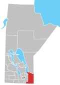
Shoal Lake 39
Indian reserve in Canada
49°30′N 95°09′W / 49.500°N 95.150°W / 49.500; -95.150 Canada
 Manitoba,
  Ontario
Shoal Lake 39 is a First Nations reserve[1] on Shoal Lake straddling the border between Manitoba and Ontario. It is one of the reserves of the Iskatewizaagegan 39 Independent First Nation.
References
- ^ a b Indigenous and Northern Affairs Canada profile
External links
- Canada Lands Survey System
- v
- t
- e
Kenora District, Ontario
- Dryden
- Kenora

- Animakee Wa Zhing 37
- Asubpeeschoseewagong
- Attawapiskat
- Bearskin Lake
- Big Grassy
- Buffalo Point
- Cat Lake
- Deer Lake
- Eabametoong
- Eagle Lake
- Fort Albany
- Fort Severn
- Iskatewizaagegan 39
- Kasabonika Lake
- Kashechewan
- Keewaywin
- Kingfisher
- Kitchenuhmaykoosib Inninuwug
- Lac Seul
- Marten Falls
- Mishkeegogamang
- Muskrat Dam Lake
- Naongashiing
- Naotkamegwanning
- Neskantaga
- Nibinamik
- Niisaachewan
- North Caribou Lake
- North Spirit Lake
- Northwest Angle 33
- Obashkaandagaang Bay
- Onigaming
- Pikangikum
- Poplar Hill
- Sachigo Lake
- Sandy Lake
- Shoal Lake 40
- Slate Falls
- Wabaseemoong
- Wabauskang
- Wabigoon Lake
- Wapekeka
- Wauzhushk Onigum
- Wawakapewin
- Webequie
- Weenusk
- Wunnumin Lake
- Agency 30
- Attawapiskat 91
- Attawapiskat 91A
- Bearskin Lake
- Cat Lake 63C
- The Dalles 38C
- Deer Lake
- Eagle Lake 27
- English River 21
- Fort Albany 67 (part)
- Fort Hope 64
- Fort Severn 89
- Kasabonika Lake
- Kee-Way-Win
- Kenora 38B
- Kingfisher 2A
- Kingfisher 3A
- Kingfisher Lake 1
- Kitchenuhmaykoosib Aaki 84
- Lac Seul 28
- Lake of the Woods 31B
- Lake of the Woods 31C
- Lake of the Woods 31G
- Lake of the Woods 35J
- Lake of the Woods 37
- Lake of the Woods 37B
- Marten Falls 65
- Muskrat Dam Lake
- Naongashing 35A
- Neskantaga
- North Spirit Lake
- Northwest Angle 33B
- Northwest Angle 34C & 37B
- Obabikong 35B
- One Man Lake 29
- Osnaburgh 63B
- Pikangikum 14
- Poplar Hill
- Rat Portage 38A
- Sabaskong Bay 35C (part)
- Sabaskong Bay 35D
- Sabaskong Bay 35F (part)
- Sachigo Lake 1
- Sachigo Lake 2
- Sachigo Lake 3
- Sandy Lake 88
- Shoal Lake 31J
- Shoal Lake 34B1
- Shoal Lake 34B2
- Shoal Lake 37A (part)
- Shoal Lake 39 (part)
- Shoal Lake 39A (part)
- Shoal Lake 40 (part)
- Swan Lake 29
- Wabaseemoong
- Wabauskang 21
- Wabigoon Lake 27
- Wapekeka 1
- Wapekeka 2
- Wawakapewin
- Weagamow Lake 87
- Webequie
- Winisk 90
- Whitefish Bay 32A
- Whitefish Bay 33A
- Whitefish Bay 34A
- Wunnumin 1
- Wunnumin 2
- Yellow Girl Bay 32B
- Greater Oxdrift
- KeeMan
- Melgund
- Minaki
- Pellatt, Pelican, Umbach, Gidley
- Redditt
- Round Lake
- Wabigoon
communities
- See also
- Communities in Kenora District
- Census divisions of Ontario
 | This article about an Indian reserve in Ontario is a stub. You can help Wikipedia by expanding it. |
- v
- t
- e
 | This Northern Ontario geographical article is a stub. You can help Wikipedia by expanding it. |
- v
- t
- e
 | This Manitoba location article is a stub. You can help Wikipedia by expanding it. |
- v
- t
- e
 | This First Nations in Canada-related article is a stub. You can help Wikipedia by expanding it. |
- v
- t
- e


