Saline Township, Michigan
Civil township in Michigan, United States
42°07′00″N 83°49′00″W / 42.11667°N 83.81667°W / 42.11667; -83.81667 (2020)
Saline Township is a civil township of Washtenaw County in the U.S. state of Michigan. The population was 2,277 at the 2020 census.[3] The city of Saline borders the township on the northeast, and the two are administered autonomously.
Communities
- Benton is an unincorporated community located within the township at 42°07′44″N 83°51′44″W / 42.12889°N 83.86222°W / 42.12889; -83.86222.[4] Benton was originally settled along the Detroit–Chicago Pike (present-day U.S. Route 12) with a post office on May 8, 1834. The post office operated until May 21, 1883 but was restored from September 13, 1883 until it ultimately closed on January 5, 1885.[5]
- Union District is a historic community located within the township. A rural post office operated here from May 28, 1836 until September 26, 1859.[6]
Geography
According to the U.S. Census Bureau, the township has a total area of 34.79 square miles (90.11 km2), of which 34.69 square miles (89.85 km2) is land and 0.10 square miles (0.26 km2) (0.29%) is water.[7]
Major highways
 US 12 (West Michigan Avenue) runs southwest through the center of the township.

Demographics
As of the 2010 census Saline Township had a population of 1,896. The racial and ethnic makeup of the population was 93.9% white, 2.1% black or African American, 0.2% Native American, 0.8% Asian, 0.1% Pacific Islander, 0.7% from some other race and 2.3% from two or more races. 2.5% of the population was Hispanic or Latino of any race.[8]
As of the census[1] of 2000, there were 1,302 people, 460 households, and 372 families residing in the township. The population density was 37.4 inhabitants per square mile (14.4/km2). There were 473 housing units at an average density of 13.6 per square mile (5.2/km2). The racial makeup of the township was 97.70% White, 0.69% African American, 0.69% Asian, and 0.92% from two or more races. Hispanic or Latino of any race were 0.46% of the population.
There were 460 households, out of which 36.5% had children under the age of 18 living with them, 72.8% were married couples living together, 3.7% had a female householder with no husband present, and 19.1% were non-families. 14.6% of all households were made up of individuals, and 5.7% had someone living alone who was 65 years of age or older. The average household size was 2.82 and the average family size was 3.13.
In the township the population was spread out, with 25.7% under the age of 18, 7.0% from 18 to 24, 27.1% from 25 to 44, 29.0% from 45 to 64, and 11.2% who were 65 years of age or older. The median age was 40 years. For every 100 females, there were 99.1 males. For every 100 females age 18 and over, there were 102.7 males.
The median income for a household in the township was $77,024, and the median income for a family was $84,129. Males had a median income of $48,235 versus $37,212 for females. The per capita income for the township was $30,630. About 2.4% of families and 2.5% of the population were below the poverty line, including none of those under age 18 and 5.2% of those age 65 or over.
Education
Saline Township is served by three public school districts. The vast majority of the township is served by Saline Area Schools. A very small portion of the southwest corner is served by Clinton Community Schools to the southwest in Lenawee County. Milan Area Schools serves a very small area of the southeast corner of the township.[9]
Images
-
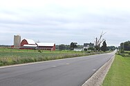
 Farmland on Marion Road
 -
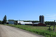
 Saline Mills
 -
 Farmland along Ausin Road


References
- ^ a b "U.S. Census website". United States Census Bureau. Retrieved January 31, 2008.
- ^ U.S. Geological Survey Geographic Names Information System: Saline Township, Michigan
- ^ "Explore Census Data". data.census.gov. Retrieved April 21, 2024.
- ^ U.S. Geological Survey Geographic Names Information System: Benton, Michigan
- ^ Romig 1986, pp. 56–57.
- ^ Romig 1986, p. 566.
- ^ "Geographic Identifiers: 2010 Demographic Profile Data (G001): Saline township, Washtenaw County, Michigan". United States Census Bureau. Retrieved July 10, 2012.
- ^ 2010 general profile of population and housing characteristics for Saline Township from the US census
- ^ Michigan Geographic Framework (November 15, 2013). "Washtenaw County School Districts" (PDF). Archived (PDF) from the original on August 21, 2014. Retrieved July 22, 2021.
Sources
- Romig, Walter (October 1, 1986) [1973]. Michigan Place Names: The History of the Founding and the Naming of More Than Five Thousand Past and Present Michigan Communities (Paperback). Great Lakes Books Series. Detroit, Michigan: Wayne State University Press. pp. 56–57, 566. ISBN 978-0-8143-1838-6.
External links
Wikimedia Commons has media related to Saline Township, Michigan.
- Saline Township official website
- v
- t
- e
Municipalities and communities of Washtenaw County, Michigan, United States
County seat: Ann Arbor

communities
- Benton
- Bridgewater
- Brookville
- Delhi Mills
- Dixboro
- Dover
- Eastlawn
- Emery
- Foster
- Fourmile Lake
- Frains Lake
- Geddes
- Guthrie
- Hudson Mills
- Jerusalem
- Lima Center
- Lincoln
- Lyndon Center
- Mooreville
- Northfield
- Notten
- Paint Creek
- Rawsonville‡
- River Raisin
- Rogers Corner
- Rowes Corner
- Salem
- Scio
- Sharon Hollow
- Stony Creek
- Superior
- Sylvan Center
- Webster
- Whittaker
- Willis
- Willow Run
- Worden
- Collins Plains
- Eaton Mills
- Eckert
- Elba
- Fredonia
- Freedom
- Fuller
- Geer
- Gravel Run
- Iron Creek
- Kavanaugh Lake
- Lodi
- Lucerne
- Mallett's Creek
- Nebraska
- Nelsonville
- Nora
- North Lake
- Pierceville
- Pittsfield
- Sharon
- Sharon Plain
- Sharonville
- Silver Lake
- Spike
- Sterling
- Summit
- Union District
- Urania
- Walsh
- Weinsburg
- Woodruff's Grove
‡This populated place also has portions in an adjacent county or counties
- Michigan portal
- United States portal


