Racovița, Vâlcea
Commune in Vâlcea, Romania
(2020–2024) (2021-12-01)[1]
247062
Racovița is a commune located in Vâlcea County, Muntenia, Romania. It is composed of seven villages: Balota, Blănoiu, Bradu-Clocotici, Copăceni, Gruiu Lupului, Racovița, and Tuțulești.
The commune is situated in the foothills of the Southern Carpathians, at altitude of 338 m (1,109 ft). It lies on the banks of the Olt River and its left tributary, the Pârâul Sec.
Racovița is the site of two ancient Roman forts, Praetorium (Racovița) and Praetorium (castra of Copăceni).
References
- ^ "Populaţia rezidentă după grupa de vârstă, pe județe și municipii, orașe, comune, la 1 decembrie 2021" (XLS). National Institute of Statistics.
-
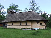 Wooden church in Copăceni
 -
 Cornet tunnel in Tuțulești


- v
- t
- e


