Peña Adobe Park
Park and Historical place in Solano County, United States
38°20′14″N 122°00′56″W / 38.33729°N 122.0155°W / 38.33729; -122.0155
- 1843, 181 years ago


Location of Peña Adobe Park in California
Show map of California
Peña Adobe Park (the United States)
Show map of the United StatesPeña Adobe Park (Peña Adobe Regional Park) is a 8-acre park (3.2 ha) in Vacaville, California. The Peña Adobe Regional Park has a Vaca-Peña Adobe Visitor Center and has 40 miles of trails. Peña Adobe Park is in the 306-acre Lagoon Valley Park (124 ha). The parks were part of Juan Felipe Peña land grant Rancho Los Putos. The park is both a recreational park and place with historical sites.[2][3][4][5]
Description
Peña Adobe Park has:[6]
- Peña Adobe (Vaca-Peña Adobe) a National Register of Historic Places[7]
- Pioneer monument to Edwin Markham[8]
- The Pioneer Monument[9]
- Mowers-Goheen Museum[10]
- Willis Linn Jepson Memorial Garden[11][10]
- Indian Council Ground[10]
- Pioneer monument to Edwin Markham[8]
- Peñas Point Trail[4]
- Bear Valley Loop Trail[4]
- BBQ Grills[2]
- Biking Trails[2]
- Hiking Trails[2]
- Horseshoe Pits[2]
- Open Space Fields[2]
- Public Restrooms[2]
- Picnic Shelters for rent[2]
- Outdoor amphitheater[4]
Lagoon Valley Park
Lagoon Valley Park has:[12][13]
- Peña Adobe Community Center
- Marsh Creek Trail
- Prunus Loop Trail
- Quercus Trail
- Thleynanti Trail
- Hills
- Horseshoe pits
- Lagoon Lake 100-acre
- Fishing
- Non-motorized boating - for kayakers
- Archery
- Electric model flying field
- Disc golf - 27-hole
- Large dog park
- bike trails
- Equestrians trails
Peña Adobe Cemetery
In the Peña Adobe Park is the historical site on the northern trail of Peña Adobe Park. Pena Adobe Cemetery is a historic graveyard. Peña Adobe Cemetery has been moved a few times. For some years it was disrepair. From 1917 to 1920 the 30,000-square-foot graveyard had about 389 wooden marked graves abandoned and the site used for sheep grazing by rancher, William B. O’Connor who had bought the land. The graves were moved in May 1966. The old Cemetery in Peña Adobe Park is a 38°20′20″N 122°00′46″W / 38.33888°N 122.01269°W / 38.33888; -122.01269[14]
Jack Hume Grove
In the Peña Adobe Park is the Historical Jack Hume Grove named after William Jack and Charles Hume built in 1850. Jack Hume Grove grew crops on the land. In 1897 a railroad line was built at Jack Hume Grove to move his crops to San Francisco for sell. Jack Hume Grove grew fruit, vegetables and nuts. The site if Jack Hume Grove is on the northern trail of Peña Adobe Park at 38°20′24″N 122°00′38″W / 38.33988°N 122.010694°W / 38.33988; -122.010694 .[15]
Historic Markers
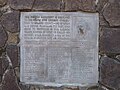
- Peña Adobe Park Marker.[16]
- A Rancho Los Putos historic marker, was placed at the site by Native Daughters of the Golden West in working with the California State Park Commission in 1955[5]
- The Pioneer Monument[9]
- William Gordon Huff Marker placed by The Sam Brannan Chapter 1004, Ancient and Honorable Order of E Clampus Vitus on August 16, 1984.[8]
- Unknown Pioneer Ranchers, by City of Vacaville and Yerba Buena Chapter, E Clampus Vitus in 1974.[17]
- The Valley Marker, near park not in park.[18]
Gallery
-
 The Pioneer Monument at Pena Adobe Park
 -
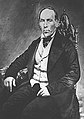 Juan Felipe Peña
 -
 Juan Manuel Vaca, who along with Juan Felipe Peña, owned Rancho Los Putos
 -
 Edwin Markham
 -
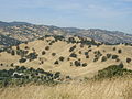 Park Hillsides in Summer
 -
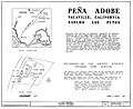 Pena Adobe Park map by NPS in 1966


See also
- California Historical Landmarks in Solano County
- National Register of Historic Places listings in Solano County, California
References
- ^ "Welcome | Pena Adobe Historical Society". www.penaadobe.org.
- ^ a b c d e f g h "Facility Directory | Vacaville, CA". www.ci.vacaville.ca.us.
- ^ "Pena Adobe/ Lagoon Valley Park". Visit Vacaville.
- ^ a b c d "Peña Adobe Regional Park". Fentons Creamery.
- ^ a b "Rancho Los Putos Historical Marker". www.hmdb.org.
- ^ "Lagoon Valley/Pena Adobe Regional Park". Fentons Creamery.
- ^ Wood Young (July 8, 1970). "National Register of Historic Places Inventory/Nomination: Peña Adobe / The Peña Adobe on Los Putos Rancho". National Park Service. Retrieved August 13, 2017. With three photos from 1965.
- ^ a b c "William Gordon Huff Historical Marker". www.hmdb.org.
- ^ a b "Pioneer Monument Historical Marker". www.hmdb.org.
- ^ a b c "Pena Adobe Historical Society". Visit Vacaville.
- ^ "Vacaville Native Plant Garden to be Revisited - CNPS Jepson Chapter". www.jepson.cnps.org.
- ^ "Lagoon Valley Park | Vacaville, CA". www.ci.vacaville.ca.us.
- ^ "Lagoon Valley Park". Fentons Creamery.
- ^ "Peña Adobe Cemetery, Vacaville". September 1, 2020.
- ^ "Jack Hume Grove in Vacaville California". Fentons Creamery.
- ^ "Peña Adobe Park Historical Marker". www.hmdb.org.
- ^ "Unknown Pioneer Ranchers Historical Marker". www.hmdb.org.
- ^ "The Valley Historical Marker". www.hmdb.org.
- v
- t
- e
water
- Bodega Bay
- Carquinez Strait
- Clifton Forebay
- Golden Gate
- Grizzly Bay
- Guadalupe River
- Half Moon Bay
- Lake Berryessa
- Napa River
- Oakland Estuary
- Petaluma River
- Richardson Bay
- Richmond Inner Harbor
- Russian River
- Sacramento River
- San Francisco Bay
- San Leandro Bay
- San Pablo Bay
- Sonoma Creek
- Suisun Bay
- Tomales Bay

and
towns
| Major cities | |
|---|---|
| 100k–250k | |
| 50k–100k | |
| 25k–50k | |
| 10k–25k | |
| Under 10k |
over 10k
Municipalities and communities of Solano County, California, United States | ||
|---|---|---|
County seat: Fairfield | ||
| Cities |  | |
| CDPs | ||
| Unincorporated communities | ||
| Ghost town | ||
| ||


