Pázmánd
Place in Fejér, Hungary

Flag
Coat of arms
 Hungary
 (2004)
2476
Pázmánd is a village in Fejér county, Hungary. As of 2004, it had 2,015 residents.
Gallery
-
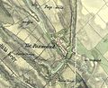
 The map of Pázmánd from the First Military Mapping Survey of Austria Empire.
 -
 The map of Pázmánd from the Second Military Mapping Survey of Austria Empire.
 -
 The map of Pázmánd from the 3rd Military Mapping Survey of Austria Empire.


External links
 Media related to Pázmánd at Wikimedia Commons
- Street map (in Hungarian)
- v
- t
- e
- Dunaújváros
- Székesfehérvár (county seat)


- Alap
- Alcsútdoboz
- Alsószentiván
- Bakonycsernye
- Bakonykúti
- Balinka
- Baracs
- Baracska
- Beloiannisz
- Besnyő
- Bodmér
- Csabdi
- Csákberény
- Csókakő
- Csősz
- Csór
- Daruszentmiklós
- Dég
- Fehérvárcsurgó
- Felcsút
- Füle
- Gánt
- Gyúró
- Hantos
- Igar
- Iszkaszentgyörgy
- Isztimér
- Iváncsa
- Jenő
- Kajászó
- Káloz
- Kápolnásnyék
- Kincsesbánya
- Kisapostag
- Kisláng
- Kulcs
- Kőszárhegy
- Lovasberény
- Magyaralmás
- Mány
- Mátyásdomb
- Mezőkomárom
- Mezőszentgyörgy
- Mezőszilas
- Moha
- Nadap
- Nádasdladány
- Nagykarácsony
- Nagylók
- Nagyveleg
- Nagyvenyim
- Óbarok
- Pákozd
- Pátka
- Pázmánd
- Pusztavám
- Ráckeresztúr
- Sáregres
- Sárkeresztes
- Sárkeresztúr
- Sárkeszi
- Sárszentágota
- Sárszentmihály
- Söréd
- Sukoró
- Szabadegyháza
- Szabadhídvég
- Szár
- Tabajd
- Tác
- Tordas
- Újbarok
- Úrhida
- Vajta
- Vál
- Vereb
- Vértesacsa
- Vértesboglár
- Zámoly
- Zichyújfalu
- History
- Geography
- Government
- Economy
- Culture
- Tourism
 | This Fejér location article is a stub. You can help Wikipedia by expanding it. |
- v
- t
- e


