Nordwestuckermark
Municipality in Brandenburg, Germany

Coat of arms
Location of Nordwestuckermark within Uckermark district

(2020–28) Roland Klatt[1]
(2022-12-31)[2]
17291
Nordwestuckermark is a municipality in the Uckermark district, in Brandenburg, Germany.
History and community structure
The community Nordwestuckermark was formed on 1 November 2001 from the previously independent municipalities Ferdinandshorst, Fürstenwerder, Gollmitz, Kraatz, Naugarten, Röpersdorf/Sternhagen, Schapow, Schönermark und Weggun (Amt Nordwestuckermark) and the municipality Holzendorf (department Prenzlau-Land).
The community Nordwestuckermark has the following districts:
|
|
|
Demography
-
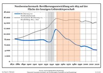 Development of population since 1875 within the current Boundaries (Blue Line: Population; Dotted Line: Comparison to Population development in Brandenburg state; Grey Background: Time of Nazi Germany; Red Background: Time of communist East Germany)
 -
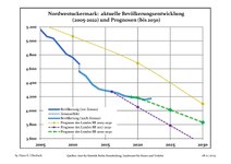 Recent Population Development and Projections (Population Development before Census 2011 (blue line); Recent Population Development according to the Census in Germany in 2011 (blue bordered line); Official projections for 2005-2030 (yellow line); for 2017-2030 (scarlet line); for 2020-2030 (green line)


|
|
|
Photo gallery
- Fürstenwerder
-

-
-


See also
- Fürstenwerder
- Großer See
References
- ^ Landkreis Uckermark Wahl der Bürgermeisterin / des Bürgermeisters, accessed 4 July 2021.
- ^ "Bevölkerungsentwicklung und Bevölkerungsstandim Land Brandenburg Dezember 2022" (PDF). Amt für Statistik Berlin-Brandenburg (in German). June 2023.
- ^ Detailed data sources are to be found in the Wikimedia Commons.Population Projection Brandenburg at Wikimedia Commons
- v
- t
- e
Towns and municipalities in Uckermark
- Angermünde
- Boitzenburger Land
- Brüssow
- Carmzow-Wallmow
- Casekow
- Flieth-Stegelitz
- Gartz
- Gerswalde
- Göritz
- Gramzow
- Grünow
- Hohenselchow-Groß Pinnow
- Lychen
- Mescherin
- Milmersdorf
- Mittenwalde
- Nordwestuckermark
- Oberuckersee
- Pinnow
- Prenzlau
- Randowtal
- Schenkenberg
- Schönfeld
- Schwedt
- Tantow
- Temmen-Ringenwalde
- Templin
- Uckerfelde
- Uckerland
- Zichow

Wikimedia Commons has media related to Nordwestuckermark.
Authority control databases | |
|---|---|
| International |
|
| National |
|
| Geographic |
|
 | This Brandenburg location article is a stub. You can help Wikipedia by expanding it. |
- v
- t
- e


