National Register of Historic Places listings in Yonkers, New York

This is a list of the National Register of Historic Places entries in Yonkers, New York, United States. See also National Register of Historic Places listings in Westchester County, New York for all others in the county.
Map all coordinates using OpenStreetMap
Download coordinates as:
- KML
- GPX (all coordinates)
- GPX (primary coordinates)
- GPX (secondary coordinates)
This is intended to be a complete list of properties and districts listed on the National Register of Historic Places in Yonkers, New York. The locations of National Register properties and districts (at least for all showing latitude and longitude coordinates below) may be seen in an online map by clicking on "Map of all coordinates".[1]
This National Park Service list is complete through NPS recent listings posted May 3, 2024.[2]
| Albany (Albany) – Allegany – Bronx – Broome – Cattaraugus – Cayuga – Chautauqua – Chemung – Chenango – Clinton – Columbia – Cortland – Delaware – Dutchess (Poughkeepsie, Rhinebeck) – Erie (Buffalo) – Essex – Franklin – Fulton – Genesee – Greene – Hamilton – Herkimer – Jefferson – Kings – Lewis – Livingston – Madison – Monroe (Rochester) – Montgomery – Nassau – New York (Below 14th Street, 14th to 59th Streets, 59th to 110th Streets, Above 110th Street, Islands) – Niagara (Niagara Falls) – Oneida – Onondaga (Syracuse) – Ontario – Orange – Orleans – Oswego – Otsego – Putnam – Queens – Rensselaer – Richmond – Rockland – St. Lawrence – Saratoga – Schenectady – Schoharie – Schuyler – Seneca – Steuben – Suffolk – Sullivan – Tioga – Tompkins – Ulster – Warren – Washington – Wayne – Westchester (Northern, Southern, New Rochelle, Peekskill, Yonkers) – Wyoming – Yates |
Current listings
| [3] | Name on the Register | Image | Date listed[4] | Location | City or town | Description |
|---|---|---|---|---|---|---|
| 1 | Bell Place-Locust Avenue Historic District | 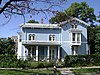 | August 29, 1985 (#85001936) | Roughly bounded by Cromwell Pl., Locust Hill Ave., Baldwin Pl. & N. Broadway 40°56′09″N 73°53′49″W / 40.9358°N 73.8969°W / 40.9358; -73.8969 (Bell Place-Locust Avenue Historic District) | Yonkers | |
| 2 | John Copcutt Mansion |  | September 12, 1985 (#85002283) | 239 Nepperhan Ave. 40°56′07″N 73°53′33″W / 40.9353°N 73.8925°W / 40.9353; -73.8925 (John Copcutt Mansion) | Yonkers | |
| 3 | Old Croton Aqueduct | 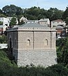 | December 2, 1974 (#74001324) | Runs N from Yonkers to New Croton Dam 41°00′52″N 73°53′14″W / 41.0144°N 73.8872°W / 41.0144; -73.8872 (Old Croton Aqueduct) | Yonkers | Extends into other parts of Westchester County. |
| 4 | Delavan Terrace Historic District | 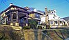 | September 15, 1983 (#83001827) | Roughly bounded by Delavan Terr. and Palisade and Park Aves. 40°57′00″N 73°53′33″W / 40.95°N 73.8925°W / 40.95; -73.8925 (Delavan Terrace Historic District) | Yonkers | Small residential street with homes of many important local residents in early 20th century |
| 5 | Ethan Flagg House-Blessed Sacrament Monastery |  | August 12, 1998 (#98001075) | 23 Park Ave. 40°56′25″N 73°53′34″W / 40.9403°N 73.8928°W / 40.9403; -73.8928 (Ethan Flagg House-Blessed Sacrament Monastery) | Yonkers | |
| 6 | Halcyon Place Historic District |  | January 11, 1991 (#90002145) | Halcyon Pl. 40°56′41″N 73°53′49″W / 40.9447°N 73.8969°W / 40.9447; -73.8969 (Halcyon Place Historic District) | Yonkers | |
| 7 | Eleazer Hart House |  | July 29, 1982 (#82003417) | 243 Bronxville Rd. 40°56′30″N 73°50′28″W / 40.9416°N 73.8411°W / 40.9416; -73.8411 (Eleazer Hart House) | Yonkers | |
| 8 | Leffingwell–Batcheller House |  | February 23, 2015 (#15000036) | 250 Palisade Ave. 40°56′31″N 73°53′33″W / 40.942°N 73.8925°W / 40.942; -73.8925 (Leffingwell–Batcheller House) | Yonkers | Large R. H. Robertson Queen Anne Style mansion from late 1880s |
| 9 | Metropolitan Life Insurance Company Hall of Records |  | September 3, 2014 (#14000543) | 759 Palmer Rd. 40°56′34″N 73°50′57″W / 40.9429°N 73.8492°W / 40.9429; -73.8492 (Metropolitan Life Insurance Company Hall of Records) | Yonkers | 1906 neoclassical building is one of the earliest built by an insurance company to house archives |
| 10 | Mott Mill |  | January 28, 2004 (#03001519) | 11-23 St. Casimir Ave. 40°56′05″N 73°53′38″W / 40.9347°N 73.8939°W / 40.9347; -73.8939 (Mott Mill) | Yonkers (Getty Square) | |
| 11 | New York Central & Hudson River Railroad Power Station |  | February 12, 2021 (#100006146) | 45A Water Grant St. 40°57′05″N 73°53′58″W / 40.9515°N 73.8994°W / 40.9515; -73.8994 (New York Central & Hudson River Railroad Power Station) | Northwest Yonkers (Glenwood) | |
| 12 | Philipsburgh Building |  | May 22, 2002 (#02000552) | 2-8 Hudson St. 40°55′59″N 73°54′00″W / 40.9331°N 73.9°W / 40.9331; -73.9 (Philipsburgh Building) | Yonkers (Getty Square) | |
| 13 | Philipse Manor Hall |  | October 15, 1966 (#66000585) | Warburton Ave. and Dock St. 40°56′08″N 73°53′58″W / 40.9356°N 73.8994°W / 40.9356; -73.8994 (Philipse Manor Hall) | Yonkers (Getty Square) | |
| 14 | Plashbourne Estate |  | August 2, 2007 (#07000777) | 51 Carlton Rd. 40°56′20″N 73°50′52″W / 40.9389°N 73.8479°W / 40.9389; -73.8479 (Plashbourne Estate) | Yonkers (Lawrence Park West) | |
| 15 | Proctor's Theater |  | November 21, 2008 (#08001083) | 53 S. Broadway 40°55′48″N 73°53′59″W / 40.9301°N 73.8997°W / 40.9301; -73.8997 (Proctor's Theater) | Yonkers (Getty Square) | |
| 16 | Public Bath House No. 2 |  | October 21, 1985 (#85003365) | 27 Vineyard Ave. 40°56′25″N 73°53′19″W / 40.9403°N 73.8886°W / 40.9403; -73.8886 (Public Bath House No. 2) | Yonkers | |
| 17 | Public Bath House No. 3 | 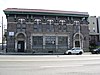 | October 21, 1985 (#85003366) | 48 Yonkers Ave. 40°56′06″N 73°53′23″W / 40.935°N 73.8897°W / 40.935; -73.8897 (Public Bath House No. 3) | Yonkers (Getty Square and Nodine Hill) | |
| 18 | Public Bath House No. 4 |  | October 21, 1985 (#85003367) | 138 Linden St. 40°55′51″N 73°53′33″W / 40.9308°N 73.8925°W / 40.9308; -73.8925 (Public Bath House No. 4) | Yonkers (Nodine Hill) | |
| 19 | Public School No. 13 |  | April 18, 2007 (#07000332) | 160 McLean Ave. 40°54′57″N 73°53′26″W / 40.9158°N 73.8906°W / 40.9158; -73.8906 (Public School No. 13) | Yonkers (Park Hill) | |
| 20 | Sherwood House |  | May 10, 1984 (#84003434) | 340 Tuckahoe Rd. 40°57′07″N 73°51′19″W / 40.9519°N 73.8553°W / 40.9519; -73.8553 (Sherwood House) | Yonkers (CenTuck) | Now a house museum operated by the Yonkers Historical Society |
| 21 | Alexander Smith Carpet Mills Historic District |  | August 11, 1983 (#83001832) | Roughly bounded by Saw Mill River Rd., Orchard St., Lake and Ashburton Aves. 40°56′33″N 73°53′01″W / 40.9425°N 73.8836°W / 40.9425; -73.8836 (Alexander Smith Carpet Mills Historic District) | Yonkers (Getty Square) | |
| 22 | St. John's Protestant Episcopal Church |  | July 29, 1982 (#82003418) | One Hudson St. 40°56′01″N 73°53′56″W / 40.9336°N 73.8989°W / 40.9336; -73.8989 (St. John's Protestant Episcopal Church) | Yonkers (Getty Square) | |
| 23 | W. B. Thompson Mansion |  | October 29, 1982 (#82001277) | 1061 N. Broadway 40°58′20″N 73°53′05″W / 40.9722°N 73.8847°W / 40.9722; -73.8847 (W. B. Thompson Mansion) | Yonkers (Greystone) | 1912 Renaissance Revival mansion is one of the few estates left in city from the early 20th century. |
| 24 | John Bond Trevor House |  | June 19, 1972 (#72000921) | 511 Warburton Ave. 40°57′12″N 73°53′54″W / 40.9533°N 73.8983°W / 40.9533; -73.8983 (John Bond Trevor House) | Yonkers (Glenwood) | Part of Hudson River Museum |
| 25 | Untermyer Park | 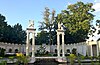 | May 31, 1974 (#74002263) | Warburton Ave. and N. Broadway S. of jct. with Odell Ave. 40°58′00″N 73°53′16″W / 40.9667°N 73.8878°W / 40.9667; -73.8878 (Untermyer Park) | Yonkers (Greystone) | |
| 26 | US Post Office-Yonkers |  | May 11, 1989 (#88002448) | 79-81 Main St. 40°56′05″N 73°54′08″W / 40.9347°N 73.9022°W / 40.9347; -73.9022 (US Post Office-Yonkers) | Yonkers (Getty Square) | 1927 stone building shows hints of Art Deco in its Classical Revival styling |
| 27 | Westminster Presbyterian Church | Upload image | May 5, 2023 (#100008899) | 76 Warburton Ave. 40°56′14″N 73°53′55″W / 40.9373°N 73.8985°W / 40.9373; -73.8985 (Westminster Presbyterian Church) | Yonkers (Getty Square) | |
| 28 | Yonkers Trolley Barn |  | March 6, 2002 (#02000141) | 92 Main St. 40°56′03″N 73°54′12″W / 40.9342°N 73.9033°W / 40.9342; -73.9033 (Yonkers Trolley Barn) | Yonkers (Getty Square) | 1903 Renaissance Revival brick building is last remaining trolley barn in county. Was city offices afterward; now used as apartments. |
| 29 | Yonkers Water Works |  | July 21, 1982 (#82003419) | Properties on Saw Mill River Road, Tuckahoe Road, and at the Grassy Sprain Reservoir dam 40°57′29″N 73°51′33″W / 40.9581°N 73.8592°W / 40.9581; -73.8592 (Yonkers Water Works) | Yonkers (CenTuck) |
Former listings
| [3] | Name on the Register | Image | Date listed | Date removed | Location | City or town | Description |
|---|---|---|---|---|---|---|---|
| 1 | Edwin H. Armstrong House |  | January 7, 1976 (#76001296) | March 5, 1986 | 1032 Warburton Ave. | Yonkers (Greystone) |
See also
Wikimedia Commons has media related to National Register of Historic Places in Yonkers, New York.
- National Register of Historic Places listings in southern Westchester County, New York
- National Register of Historic Places listings in New York
References
- ^ The latitude and longitude information provided in this table was derived originally from the National Register Information System, which has been found to be fairly accurate for about 99% of listings. Some locations in this table may have been corrected to current GPS standards.
- ^ National Park Service, United States Department of the Interior, "National Register of Historic Places: Weekly List Actions", retrieved May 3, 2024.
- ^ a b Numbers represent an alphabetical ordering by significant words. Various colorings, defined here, differentiate National Historic Landmarks and historic districts from other NRHP buildings, structures, sites or objects.
- ^ The eight-digit number below each date is the number assigned to each location in the National Register Information System database, which can be viewed by clicking the number.
- v
- t
- e
U.S. National Register of Historic Places in New York

by county
- Albany
- Allegany
- Bronx
- Broome
- Cattaraugus
- Cayuga
- Chautauqua
- Chemung
- Chenango
- Clinton
- Columbia
- Cortland
- Delaware
- Dutchess
- Erie
- Essex
- Franklin
- Fulton
- Genesee
- Greene
- Hamilton
- Herkimer
- Jefferson
- Kings (Brooklyn)
- Lewis
- Livingston
- Madison
- Monroe
- Montgomery
- Nassau
- New York (Manhattan)
- Niagara
- Oneida
- Onondaga
- Ontario
- Orange
- Orleans
- Oswego
- Otsego
- Putnam
- Queens
- Rensselaer
- Richmond (Staten Island)
- Rockland
- Saratoga
- Schenectady
- Schoharie
- Schuyler
- Seneca
- St. Lawrence
- Steuben
- Suffolk
- Sullivan
- Tioga
- Tompkins
- Ulster
- Warren
- Washington
- Wayne
- Westchester
- Wyoming
- Yates
by city
 Category
 List
List National Register of Historic Places Portal


