National Register of Historic Places listings in Appling County, Georgia
This is a list of properties and districts in Appling County, Georgia that are listed on the National Register of Historic Places (NRHP).
Map all coordinates using OpenStreetMap
Download coordinates as:
- KML
- GPX (all coordinates)
- GPX (primary coordinates)
- GPX (secondary coordinates)
This National Park Service list is complete through NPS recent listings posted June 7, 2024.[1]
- v
- t
- e
Properties on the National Register of Historic Places in Georgia by county
- Appling
- Atkinson
- Bacon
- Baker
- Baldwin
- Banks
- Barrow
- Bartow
- Ben Hill
- Berrien
- Bibb
- Bleckley
- Brantley
- Brooks
- Bryan
- Bulloch
- Burke
- Butts
- Calhoun
- Camden
- Candler
- Carroll
- Catoosa
- Charlton
- Chatham
- Chattahoochee
- Chattooga
- Cherokee
- Clarke
- Clay
- Clayton
- Clinch
- Cobb
- Coffee
- Colquitt
- Columbia
- Cook
- Coweta
- Crawford
- Crisp
- Dade
- Dawson
- Decatur
- DeKalb
- Dodge
- Dooly
- Dougherty
- Douglas
- Early
- Echols
- Effingham
- Elbert
- Emanuel
- Evans
- Fannin
- Fayette
- Floyd
- Forsyth
- Franklin
- Fulton
- Gilmer
- Glascock
- Glynn
- Gordon
- Grady
- Greene
- Gwinnett
- Habersham
- Hall
- Hancock
- Haralson
- Harris
- Hart
- Heard
- Henry
- Houston
- Irwin
- Jackson
- Jasper
- Jeff Davis
- Jefferson
- Jenkins
- Johnson
- Jones
- Lamar
- Lanier
- Laurens
- Lee
- Liberty
- Lincoln
- Long
- Lowndes
- Lumpkin
- Macon
- Madison
- Marion
- McDuffie
- McIntosh
- Meriwether
- Miller
- Mitchell
- Monroe
- Montgomery
- Morgan
- Murray
- Muscogee
- Newton
- Oconee
- Oglethorpe
- Paulding
- Peach
- Pickens
- Pierce
- Pike
- Polk
- Pulaski
- Putnam
- Quitman
- Rabun
- Randolph
- Richmond
- Rockdale
- Schley
- Screven
- Seminole
- Spalding
- Stephens
- Stewart
- Sumter
- Talbot
- Taliaferro
- Tattnall
- Taylor
- Telfair
- Terrell
- Thomas
- Tift
- Toombs
- Towns
- Treutlen
- Troup
- Turner
- Twiggs
- Union
- Upson
- Walker
- Walton
- Ware
- Warren
- Washington
- Wayne
- Webster
- Wheeler
- White
- Whitfield
- Wilcox
- Wilkes
- Wilkinson
- Worth

Current listings
| [2] | Name on the Register | Image | Date listed[3] | Location | City or town | Description |
|---|---|---|---|---|---|---|
| 1 | Appling County Courthouse |  | September 18, 1980 (#80000965) | Courthouse Sq. 31°46′41″N 82°20′57″W / 31.77805°N 82.34927°W / 31.77805; -82.34927 (Appling County Courthouse) | Baxley | Built in 1908 |
| 2 | Bank of Surrency |  | January 31, 2003 (#02001742) | 80 Hart St. 31°43′29″N 82°11′55″W / 31.7247°N 82.1987°W / 31.7247; -82.1987 (Bank of Surrency) | Surrency | Built in 1911, was used as city hall as of 2007[4] |
| 3 | Citizens Banking Company | 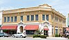 | May 2, 1985 (#85000932) | 112-116 N. Main St. 31°46′39″N 82°20′56″W / 31.7774°N 82.3488°W / 31.7774; -82.3488 (Citizens Banking Company) | Baxley | Built in 1911 |
| 4 | C. W. Deen House |  | September 30, 1982 (#82002381) | 413 N. Main St. 31°46′51″N 82°20′54″W / 31.78072°N 82.34836°W / 31.78072; -82.34836 (C. W. Deen House) | Baxley | Built between 1894 and 1897 |
| 5 | United States Post Office-Baxley, Georgia |  | July 5, 2000 (#00000755) | 124 Tippins St. 31°46′41″N 82°21′00″W / 31.77819°N 82.35012°W / 31.77819; -82.35012 (United States Post Office-Baxley, Georgia) | Baxley | Built in 1935/36, now used for the magistrate court |
References
- ^ National Park Service, United States Department of the Interior, "National Register of Historic Places: Weekly List Actions", retrieved June 7, 2024.
- ^ Numbers represent an alphabetical ordering by significant words. Various colorings, defined here, differentiate National Historic Landmarks and historic districts from other NRHP buildings, structures, sites or objects.
- ^ The eight-digit number below each date is the number assigned to each location in the National Register Information System database, which can be viewed by clicking the number.
- ^ Georgia BackRoads magazine, Spring 2007, p. 61
Wikimedia Commons has media related to National Register of Historic Places in Appling County, Georgia.
| |
|---|---|
| Topics | |
| Lists by state |
|
| Lists by insular areas | |
| Lists by associated state | |
| Other areas | |
| Related | |
| |


