Mundy Regional Park
Regional park in Western Australia
31°59′47″S 116°1′49″E / 31.99639°S 116.03028°E / -31.99639; 116.03028
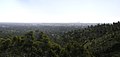
The Mundy Regional Park is a regional park located on the western edge of the Darling Scarp, approximately 22 kilometres (14 mi) east of Perth in Western Australia. The 56-hectare (140-acre) park has commanding views of the Swan Coastal Plain, the city of Perth and surrounding suburbs. The park is managed by the Department of Biodiversity, Conservation and Attractions.
Location and features
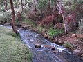
The park contains the 50-metre (164 ft) Lesmurdie Falls, formed by Lesmurdie Brook emptying over the Scarp, and the surrounding riparian and heath vegetation.[2] Wandoo, jarrah and marri trees can all be found within the park. A gravity hill exists near the carpark on Palm Terrace.
The Mundy Regional Park has multiple walking and running trails of varying difficulty and is popular for walking and running. The walking trails include: Lesmurdie Brook Loop, Lewis Road Walk, Palm Terrace Walk,Xanthorrhoea Trail, Whistlepipe Gully.
Some sections allow horse riding and off-road cycling.
Gallery


See also
 Western Australia portal
 Environment portal


- Forrestfield, Western Australia
- Lesmurdie, Western Australia
- List of waterfalls of Western Australia
References
- ^ "Department of Environment and Conservation 2009–2010 Annual Report". Annual Report. Department of Environment and Conservation: 48. 2010. ISSN 1835-114X. Archived from the original on 11 January 2011.
- ^ "About Australia - Lesmurdie Falls National Park". 2010. Archived from the original on 5 December 2008. Retrieved 17 October 2010.
External links
- Mundy Regional Park - Department of Parks and Wildlife
 Media related to Mundy Regional Park at Wikimedia Commons
- v
- t
- e
- Banyowla
- Beeliar
- Canning River
- Chapman River
- Herdsman Lake
- Jandakot
- Kalgulup
- Meelup
- Mundy
- Rockingham Lakes
- Woodman Point
- Wooroloo
- Wungong
- Yellagonga


