List of crossings of the River Weaver
List of crossings of the River Weaver north of Nantwich. Bridges which only access the island between original course and Weaver Navigation are not included.
| Status | Criteria[1] |
|---|---|
| I | Grade I listed. Bridge of exceptional interest, sometimes considered to be internationally important |
| II* | Grade II* listed. Particularly important bridge of more than special interest |
| II | Grade II listed. Bridge of national importance and special interest |
Map all coordinates using OpenStreetMap
Download coordinates as:
- KML
- GPX (all coordinates)
- GPX (primary coordinates)
- GPX (secondary coordinates)
| Crossing | Date | Coordinates | Heritage status | Locality | Notes | Image |
|---|---|---|---|---|---|---|
| Shrewbridge Road | 53°03′17″N 2°31′27″W / 53.0547°N 2.5243°W / 53.0547; -2.5243 (Shrewbridge Road) | - | Nantwich | A530 | ||
| Railway Bridge | 53°03′42″N 2°31′32″W / 53.0617°N 2.5256°W / 53.0617; -2.5256 (Nantwich Railway Bridge) | - | Nantwich | Welsh Marches line | 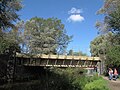 | |
| Nantwich Riverside South Footbridge | 53°03′45″N 2°31′33″W / 53.0625°N 2.5257°W / 53.0625; -2.5257 (Nantwich Footbridge) | - | Nantwich |  | ||
| Nantwich Riverside Footbridges | 53°03′57″N 2°31′30″W / 53.0659°N 2.5249°W / 53.0659; -2.5249 (Mill Island) | - | Nantwich | Several bridges accessing Mill Island |  | |
| Nantwich Bridge[2] | Early 19th Cent | 53°04′03″N 2°31′28″W / 53.0676°N 2.5245°W / 53.0676; -2.5245 (Nantwich Bridge) | II | Nantwich |  | |
| Sir Thomas Fairfax Bridge | 53°04′11″N 2°31′33″W / 53.0698°N 2.5259°W / 53.0698; -2.5259 (Sir Thomas Fairfax Bridge) | - | Nantwich | 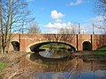 | ||
| Nantwich Riverside North Footbridges | 53°04′22″N 2°31′24″W / 53.0727°N 2.5233°W / 53.0727; -2.5233 (Nantwich Footbridges) | - | Nantwich | 3 Footbridges | 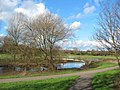 | |
| Beam Bridge | 53°04′40″N 2°31′20″W / 53.0778°N 2.5222°W / 53.0778; -2.5222 (Barony Road Bridge) | - | Nantwich | Barony Road B5074 |  | |
| Nantwich Bypass Bridge | 53°04′44″N 2°31′11″W / 53.0789°N 2.5196°W / 53.0789; -2.5196 (Nantwich Bypass Bridge) | - | Nantwich | A51 | ||
| Rail Bridge | 53°06′25″N 2°29′55″W / 53.107°N 2.4986°W / 53.107; -2.4986 (Crewe Rail Bridge) | - | Crewe | North Wales Main Line |  | |
| Church Minshull Aqueduct[3] | 1833 | 53°07′36″N 2°30′09″W / 53.1267°N 2.5026°W / 53.1267; -2.5026 (Church Minshull Aqueduct) | II | Church Minshull | Shropshire Union Canal |  |
| Farm Access Bridge | 53°08′13″N 2°30′05″W / 53.1369°N 2.5015°W / 53.1369; -2.5015 (Hoolgrave Access Bridge) | - | Church Minshull | Old Hoolgrave access |  | |
| Church Minshull Bridge[4] | 53°08′31″N 2°29′55″W / 53.1419°N 2.4985°W / 53.1419; -2.4985 (Church Minshull Bridge) | II | Church Minshull | Cross Lane |  | |
| Footbridge | 53°09′46″N 2°29′29″W / 53.1629°N 2.4915°W / 53.1629; -2.4915 (Wimboldsley Footbridge) | - | Wimboldsley | 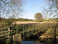 | ||
| Winsford High St Roundabout | 53°11′33″N 2°31′02″W / 53.1925°N 2.5171°W / 53.1925; -2.5171 (Winsford Road Bridge) | - | Winsford | 2 Bridges |  | |
| Weaver Parkway Footbridge [5] | 53°12′52″N 2°31′24″W / 53.2145°N 2.5233°W / 53.2145; -2.5233 (Weaver Parkway Footbridge) | - | Winsford |  | ||
| Vale Royal Locks[6] | 1890 | 53°13′44″N 2°32′24″W / 53.229°N 2.5401°W / 53.229; -2.5401 (Vale Royal Locks) | II | Hartford | Footbridge on River, locks on Navigation |  |
| Vale Railway Viaduct[7] | 1837 | 53°13′54″N 2°32′14″W / 53.2316°N 2.5372°W / 53.2316; -2.5372 (Vale Railway Viaduct) | II | Hartford | West Coast Main Line | 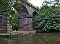 |
| Hartford Bridge | 53°14′16″N 2°31′49″W / 53.2378°N 2.5303°W / 53.2378; -2.5303 (Hartford Bridge) | - | Hartford | A556 |  | |
| Hunt's Locks[8] | 1890 | 53°15′08″N 2°31′03″W / 53.2523°N 2.5175°W / 53.2523; -2.5175 (Hunt's Locks) | II | Northwich | Locks on Navigation, Riversdale Bridge on River. |  |
| Weaver Railway Viaduct[9] | 1860 | 53°15′17″N 2°30′51″W / 53.2547°N 2.5141°W / 53.2547; -2.5141 (Weaver Railway Viaduct) | II | Northwich | Mid-Cheshire line |  |
| Hayhurst Bridge[10] | 1899 | 53°15′30″N 2°30′59″W / 53.2582°N 2.5164°W / 53.2582; -2.5164 (Hayhurst Bridge) | II | Northwich | Swing Bridge |  |
| Northwich Town Bridge[11] | 1899 | 53°15′38″N 2°30′58″W / 53.2605°N 2.516°W / 53.2605; -2.516 (Northwich Town Bridge) | II | Northwich | Swing Bridge |  |
| Winnington Turn Bridge[12] | 1909 | 53°16′14″N 2°32′20″W / 53.2705°N 2.5388°W / 53.2705; -2.5388 (Winnington Turn Bridge) | II | Winnington | Swing Bridge | 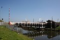 |
| Acton Bridge | 53°16′48″N 2°36′02″W / 53.2801°N 2.6005°W / 53.2801; -2.6005 (Acton Bridge) | - | A49 Swing Bridge |  | ||
| Dutton Locks[13] | 1874 | 53°17′15″N 2°37′18″W / 53.2876°N 2.6218°W / 53.2876; -2.6218 (Dutton Locks) | II | Dutton Horse Bridge on River, locks on Navigation |  | |
| Dutton Viaduct | 1837 | 53°16′57″N 2°37′41″W / 53.2826°N 2.628°W / 53.2826; -2.628 (Dutton Viaduct) | II* | West Coast Main Line Liverpool Branch |  | |
| Frodsham Bridge[14] | 1850 | 53°18′03″N 2°42′24″W / 53.3009°N 2.7067°W / 53.3009; -2.7067 (Frodsham Bridge) | II | Frodsham | Original River |  |
| Sutton Weaver Swing Bridge | 53°18′17″N 2°41′57″W / 53.3048°N 2.6993°W / 53.3048; -2.6993 (Sutton Weaver Swing Bridge) | - | Frodsham | Weaver Navigation |  | |
| Frodsham Viaduct[15] | 1850 | 53°18′09″N 2°42′32″W / 53.3025°N 2.7088°W / 53.3025; -2.7088 (Frodsham Viaduct) | II | Frodsham | Original River |  |
| Frodsham Navigation Viaduct[16] | 1850 | 53°18′22″N 2°42′05″W / 53.306°N 2.7013°W / 53.306; -2.7013 (Frodsham Navigation Viaduct) | II | Frodsham | Weaver Navigation |  |
| Weaver Viaduct | 1971 | 53°18′30″N 2°42′41″W / 53.3082°N 2.7114°W / 53.3082; -2.7114 (Weaver Viaduct) | - | Frodsham | M56 |  |
References
- ^ Listed Buildings, English Heritage, archived from the original on 9 December 2012, retrieved 22 April 2011
- ^ British Listed Buildings
- ^ British Listed Buildings
- ^ British Listed Buildings
- ^ Weaver Parkway
- ^ British Listed Buildings
- ^ British Listed Buildings
- ^ British Listed Buildings
- ^ British Listed Buildings
- ^ British Listed Buildings
- ^ British Listed Buildings
- ^ British Listed Buildings
- ^ British Listed Buildings
- ^ British Listed Buildings
- ^ British Listed Buildings
- ^ British Listed Buildings


