List of airports in the Turks and Caicos Islands
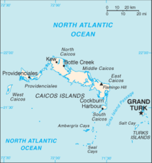

This is a list of airports in the Turks and Caicos Islands, sorted by location. The Turks and Caicos Islands are a British Overseas Territory located southeast of Mayaguana in the Bahamas and north of the island of Hispaniola. It consists of two groups of sub-tropical islands in the West Indies, the larger Caicos Islands and the smaller Turks Islands. The total population is about 36,000, of whom approximately 22,500 live on Providenciales in the Caicos Islands. Cockburn Town, the capital, is on Grand Turk Island.
Airports
Names shown in bold indicate the airport has scheduled passenger service on commercial airlines.
| Island | ICAO | IATA | Airport name | Coordinates |
|---|---|---|---|---|
| Ambergris Cay (Caicos Islands) | MBAC | Harold Charles International Airport | 21°18′2″N 71°38′28″W / 21.30056°N 71.64111°W / 21.30056; -71.64111 (Harold Charles International Airport) | |
| Grand Turk Island (Turks Islands) | MBGT | GDT | JAGS McCartney International Airport | 21°26′40″N 071°08′32″W / 21.44444°N 71.14222°W / 21.44444; -71.14222 (JAGS McCartney International Airport) |
| Middle Caicos (Caicos Islands) | MBMC | MDS | Middle Caicos Airport | 21°49′33″N 071°48′09″W / 21.82583°N 71.80250°W / 21.82583; -71.80250 (Middle Caicos Airport) |
| North Caicos (Caicos Islands) | MBNC | NCA | North Caicos Airport | 21°55′03″N 071°56′22″W / 21.91750°N 71.93944°W / 21.91750; -71.93944 (North Caicos Airport) |
| Pine Cay (Caicos Islands) | MBPI | PIC | Pine Cay Airport | 21°52′29.88″N 72°5′32.69″W / 21.8749667°N 72.0924139°W / 21.8749667; -72.0924139 (Pine Cay Airport) |
| Providenciales (Caicos Islands) | MBPV | PLS | Providenciales International Airport | 21°46′25″N 72°15′57″W / 21.77361°N 72.26583°W / 21.77361; -72.26583 (Providenciales International Airport) |
| Salt Cay (Turks Islands) | MBSY | SLX | Salt Cay Airport | 21°20′N 071°12′W / 21.333°N 71.200°W / 21.333; -71.200 (Salt Cay Airport) |
| South Caicos (Caicos Islands) | MBSC | XSC | South Caicos Airport | 21°30′57″N 071°31′43″W / 21.51583°N 71.52861°W / 21.51583; -71.52861 (South Caicos Airport) |
| West Caicos (Caicos Islands) | MB01 | West Caicos Aerodrome | 21°39′9″N 072°27′57.6″W / 21.65250°N 72.466000°W / 21.65250; -72.466000 (West Caicos Airport) |
See also
Map all coordinates using OpenStreetMap
Download coordinates as:
- KML
- GPX (all coordinates)
- GPX (primary coordinates)
- GPX (secondary coordinates)
- List of airports by ICAO code: M#MB - Turks and Caicos Islands
- List of airports in the United Kingdom and the British Crown Dependencies
- Wikipedia: WikiProject Aviation/Airline destination lists: North America#Turks and Caicos Islands (United Kingdom)
References
- Turks and Caicos Islands Government: Civil Aviation
- Turks and Caicos Tourist Board: Travel Information
- "ICAO Location Indicators by State" (PDF). International Civil Aviation Organization. 12 January 2006.
- "UN Location Codes: Turks and Caicos Islands". UN/LOCODE 2009-2. UNECE. 8 February 2010. - includes IATA codes
- Great Circle Mapper: Turks and Caicos Islands - IATA and ICAO codes
- v
- t
- e
| Smaller | |
|---|---|
| Smaller | |
|---|---|
| Smaller | |
|---|---|
| Smaller | |
|---|---|
| Smaller | |
|---|---|
| Smaller | |
|---|---|
Smaller airports handle domestic, charter or private services only
List of airports in the Americas | ||
|---|---|---|
| ||
|  | |
| Sovereign states |
| |
| ||


