List of National Natural Landmarks in Guam
Map all coordinates using OpenStreetMap
Download coordinates as:
- KML
- GPX (all coordinates)
- GPX (primary coordinates)
- GPX (secondary coordinates)
From List of National Natural Landmarks, these are the National Natural Landmarks in Guam. There are 4 in total. All sites are on lands owned by the territorial government.
| Name | Image | Date | Location | County | Description | |
|---|---|---|---|---|---|---|
| 1 | Facpi Point | 1972 | 13°20′29.61″N 144°37′57.57″E / 13.3415583°N 144.6326583°E / 13.3415583; 144.6326583 | Guam | Contains pillow lava, intersecting dikes, and a massive sea stack of black coralline limestone.[1] | |
| 2 | Fouha Point | 1972 | 13°18′25.16″N 144°39′18.91″E / 13.3069889°N 144.6552528°E / 13.3069889; 144.6552528 | Guam | Contains exposures of volcanic rock with a nearby intertidal platform of two levels of coralline limestone.[2] | |
| 3 | Mount Lamlam | 1972 | 13°20′23.13″N 144°39′56.35″E / 13.3397583°N 144.6656528°E / 13.3397583; 144.6656528 | Guam | A remnant of a great caldera.[3] | |
| 4 | Two Lovers Point (Puntan Dos Amåntes) | 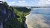 | 1972 | 13°32′5.97″N 144°48′8.83″E / 13.5349917°N 144.8024528°E / 13.5349917; 144.8024528 | Guam | A 370-foot-high (110 m) cliff exposure of massive limestone.[4] |
References
- v
- t
- e
National Natural Landmarks in the United States
- Alabama
- Alaska
- Arizona
- Arkansas
- California
- Colorado
- Connecticut
- Delaware
- Florida
- Georgia
- Hawaii
- Idaho
- Illinois
- Indiana
- Iowa
- Kansas
- Kentucky
- Louisiana
- Maine
- Maryland
- Massachusetts
- Michigan
- Minnesota
- Mississippi
- Missouri
- Montana
- Nebraska
- Nevada
- New Hampshire
- New Jersey
- New Mexico
- New York
- North Carolina
- North Dakota
- Ohio
- Oklahoma
- Oregon
- Pennsylvania
- Rhode Island
- South Carolina
- South Dakota
- Tennessee
- Texas
- Utah
- Vermont
- Virginia
- Washington
- West Virginia
- Wisconsin
- Wyoming


