List of Grade B+ listed buildings in County Londonderry

Map all coordinates using OpenStreetMap
Download coordinates as:
- KML
- GPX (all coordinates)
- GPX (primary coordinates)
- GPX (secondary coordinates)
This is a list of Grade B+ listed buildings in County Londonderry, Northern Ireland.
In Northern Ireland, the term listed building refers to a building or other structure officially designated as being of "special architectural or historic interest".[1] Grade B+ structures are those considered to be "buildings which might have merited grade A status but for detracting features such as an incomplete design, lower quality additions or alterations. Also included are buildings that because of exceptional features, interiors or environmental qualities are clearly above the general standard set by grade B buildings. A building may merit listing as grade B+ where its historic importance is greater than a similar building listed as grade B."[2]
Listing began later in Northern Ireland than in the rest of the UK; the first provision for listing was contained in the Planning (Northern Ireland) Order 1972,[3] and the current legislative basis for listing is the Planning (Northern Ireland) Order 1991.[4] Under Article 42 of the Order, the Department of the Environment of the Northern Ireland Executive is required to compile lists of buildings of "special architectural or historic interest". The responsibility for the listing process rests with the Northern Ireland Environment Agency (NIEA), an executive agency within the Department of the Environment.[4]
Following the introduction of listing, an initial survey of Northern Ireland's building stock was begun in 1974.[5] By the time of the completion of this First Survey in 1994, the listing process had developed considerably, and it was therefore decided to embark upon a Second Survey to update and cross-check the original information. As of April 2010[update], the Second Survey had been completed for 147 of Northern Ireland's 547 council wards, and completion is anticipated by 2016.[5] Information gathered during this survey, relating to both listed and unlisted buildings, is entered into the publicly accessible Northern Ireland Buildings Database.[5] A range of listing criteria, which aim to define architectural and historic interest, have been developed by the NIEA, and are used to determine whether or not to list a building.[4]
Once listed, severe restrictions are imposed on the modifications allowed to a building's structure or its fittings. Listed building consent must be obtained from local authorities prior to any alteration to such a structure.[6] There are approximately 8,500 listed buildings in Northern Ireland, representing 2% of the total building stock.[4] Of these, around 580 are listed at Grade B+.
County Londonderry covers 2,074 square kilometres (801 sq mi), and has a population of around 233,500. The County has 65 Grade B+ listed buildings.
Listed buildings
| Building address | Grid Ref.[note 1] Geo-coordinates | Type [note 2] | Local authority | Second Survey | Original Survey | HB Number [note 3] | Image |
|---|---|---|---|---|---|---|---|
| Landmore House, Aghadowey, Coleraine | House | Coleraine | B+ | HB03/03/032 |  Upload Photo
| ||
| Bovagh House, Bovagh, Coleraine | Country House | Coleraine | B+ | HB03/03/028 | Upload Photo
| ||
| Presbyterian Church, Church St./Enfield St., Portstewart | Church | Coleraine | B+ | HB03/09/001 |  Upload another image
| ||
| Bishop's Gate, Mussenden Road, Downhill, Coleraine | School | Coleraine | B+ | HB03/12/012 | Upload Photo
| ||
| Mausoleum, Downhill, Coleraine | Memorial | Coleraine | B+ | HB03/12/014 |  Upload another image
| ||
| Downhill Palace, Downhill | Rectories/ Manses etc | Coleraine | B+ | HB03/12/015 |  Upload another image
| ||
| Ice House etc, Downhill, Coleraine | Ice House | Coleraine | B+ | HB03/12/019 |  Upload another image
| ||
| The Granary, Laurel Hill House, Laurel Hill, Coleraine | Farm Buildings | Coleraine | B+ | HB03/14/005 B | Upload Photo
| ||
| St. John's R.C. Church, Kyle's Brae, Coleraine | Church | Coleraine | B+ | HB03/15/002 |  Upload another image
| ||
| St. Malachy's R.C. Church, Nursery Avenue, Coleraine | Church | Coleraine | B+ | HB03/17/016 | 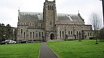 Upload another image
| ||
| Town Hall, The Diamond, Coleraine | Town Hall | Coleraine | B+ | HB03/18/001 | 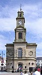 Upload another image
| ||
| St. Patrick's Church, Church St., Kingsgate St., Coleraine | Church | Coleraine | B+ | HB03/18/010 | 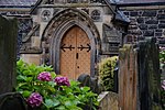 Upload another image
| ||
| Methodist Church Circular Road, Coleraine | Church | Coleraine | B+ | HB03/18/021 | 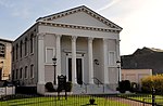 Upload another image
| ||
| Straidarran House, Clagan Road, Claudy BT47 4DB | House | Derry | B+ | B1 | HB01/01/005 |  Upload another image
| |
| Holy Trinity Church, Cumber Lower, Claudy | Church | Derry | B+ | HB01/02/008 | Upload Photo
| ||
| Northern Bank, 11 Main St., Eglinton | Bank | Derry | B+ | HB01/03/009 |  Upload another image
| ||
| 105 Rossdowney Road, Ballyoan BT47 5SU | Derry | B+ | B | HB01/05/005 | Upload Photo
| ||
| Star Factory, 79E Foyle Road, Londonderry | Factory | Derry | B+ | HB01/17/004 |  Upload another image
| ||
| St. Columba's Church, Long Tower St., Londonderry | Church | Derry | B+ | HB01/18/003 |  Upload another image
| ||
| First Derry Presbyterian Church, Upper Magazine St, Londonderry | Church | Derry | B+ | HB01/19/015 A |  Upload another image
| ||
| Northern Bank, 6 Shipquay Place, Londonderry | Bank | Derry | B+ | HB01/19/039 |  Upload another image
| ||
| Methodist Church, Carlisle Road, Londonderry | Church | Derry | B+ | HB01/19/063 | Upload Photo
| ||
| St. Eugene's Cathedral, Francis St., Londonderry | Church | Derry | B+ | HB01/21/001 |  Upload another image
| ||
| Former Presbyterian Church, Great James St., Londonderry | Church | Derry | B+ | HB01/21/009 |  Upload another image
| ||
| 33 Great James St., Londonderry | House | Derry | B+ | HB01/21/010 | Upload Photo
| ||
| Brookhall, 65 Culmore Road, Londonderry BT48 8JE | Country House | Derry | B+ | B1 | HB01/25/002 A | Upload Photo
| |
| Culmore Primary School, 181 Culmore Road, Londonderry BT48 8JH | School | Derry | B+ | B | HB01/27/006 | Upload Photo
| |
| Dogleap Powerhouse, Roe Valley Country Park, 43 Dogleap Road, Largy, Limavady BT49 9NN | Gallery/ Museum | Limavady | B+ | B+ | HB02/03/008 | Upload Photo
| |
| Knockan House, 9 Killunaght Road, Dungiven, BT47 4TU | House | Limavady | B+ | B | HB02/05/006 A | Upload Photo
| |
| Banagher Church of Ireland, Feeny Road, Rallagh, Dungiven | Church | Limavady | B+ | B | HB02/05/004 | Upload Photo
| |
| Ashpark House, 712 Glenshane Road, Feeny BT47 4TG | House | Limavady | B+ | B | HB02/05/005 A | Upload Photo
| |
| Drumcovit House, 704 Feeny Road, Feeny BT47 4SU | House | Limavady | B+ | B1 | HB02/05/008 A | Upload Photo
| |
| The Old Rectory, Glenshane Road, Dungiven BT47 | House | Limavady | B+ | B1 | HB02/05/003 A | Upload Photo
| |
| Pellipar House, Dungiven BT47 4LY | Country House | Limavady | B+ | B+ | HB02/06/007 A | Upload Photo
| |
| Carrick Footbridge. Carrick East Roe Valley Country Park, Limavady BT49 9HA | Bridge | Limavady | B+ | B+ | HB02/08/009 | Upload Photo
| |
| Tamlaghtard Rectory, 4 Duncrun Road, Glebe Magilligan, Limavady BT49 0JD | House | Limavady | B+ | B1 | HB02/09/031 | Upload Photo
| |
| Thatched House, 326 Seacoast Road, Magilligan, Limavady | House | Limavady | B+ | B1 | HB02/09/036 | Upload Photo
| |
| Tamlaght Finlagan Parish Church (C of I), Clooney Road, Ballykelly, Limavady BT49 9HS | Church | Limavady | B+ | B+ | HB02/10/009 A |  Upload another image
| |
| Walworth House, 11 Walworth Road, Ballykelly, Limavady BT49 9JU | Country House | Limavady | B+ | B1 | HB02/10/002 | Upload Photo
| |
| Aircraft Hangar, Shackleton Barracks, Ballykelly, Limavady | Store | Limavady | B+ | HB02/10/027 | Upload Photo
| ||
| Aghanloo Church of Ireland Church, Aghanloo Road, Limavady | Church | Limavady | B+ | B+ | HB02/11/010 A | 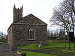 Upload another image
| |
| 2nd Presbyterian Church, Limavady Irish Green Street, Limavady BT49 9AN | Church | Limavady | B+ | B | HB02/12/026 | Upload Photo
| |
| Roe Valley Hospital (Former Workhouse), Benevenagh Avenue, Limavady BT49 OAQ | Hospital Building | Limavady | B+ | B | HB02/15/006 | Upload Photo
| |
| Weddell Bridge, Draperstown | Bridge | Magherafelt | B+ | HB08/04/013 | Upload Photo
| ||
| Ballynascreen House, Glebe, Draperstown, Magherafelt | House | Magherafelt | B+ | HB08/07/007 | Upload Photo
| ||
| 28 Deerpark Road, Old Town, Deerpark, Bellaghy, Magherafelt BT45 8LB | House | Magherafelt | B+ | B1 | HB08/09/010 | Upload Photo
| |
| Ballyscullion Park, Ballyscullion, West Bellaghy, Magherafelt | Country House | Magherafelt | B+ | HB08/09/011 A | Upload Photo
| ||
| Moyola Park, Tamniaran, Castledawson, Magherafelt | Country House | Magherafelt | B+ | HB08/10/001 | Upload Photo
| ||
| St. Columba's Church, Draperstown, Magherafelt | Church | Magherafelt | B+ | HB08/11/001 |  Upload another image
| ||
| St. Swithins Church, Church St., Magherafelt | Church | Magherafelt | B+ | HB08/15/001 |  Upload another image
| ||
| Lissan C. of I. Parish Church, Churchtown, 1 Lissan Road, Cookstown BT80 8EN | Church | Cookstown | B+ | B | HB09/03/003 | Upload Photo
| |
| St Michael's R.C. Church, 9 Clagan Road, Cookstown BT80 9XE | Church | Cookstown | B+ | B+ | HB09/03/004 | 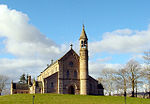 Upload another image
| |
| Lissan Rectory, 150 Moneymore Road, Cookstown BT80 9UU | Rectories/ Manses etc | Cookstown | B+ | B1 | HB09/03/001 | Upload Photo
| |
| Lissan House, Drumgrass Road, Cookstown BT80 9SW | Country House | Cookstown | B+ | B1 | HB09/03/008 A | Upload Photo
| |
| Dunmore, 99 Lough Fea Road, Cookstown BT80 9SR | House | Cookstown | B+ | B1 | HB09/03/009 | Upload Photo
| |
| Former Common Barn, 3 Springhill Road, Moneymore, Magherafelt BT45 7NG | Factory | Cookstown | B+ | B | HB09/06/022 | Upload Photo
| |
| 1-3 High Street, Moneymore, Magherafelt BT45 7PB | Public House | Cookstown | B+ | B+ | HB09/06/004 A | Upload Photo
| |
| 5-7 High Street, Moneymore, Magherafelt BT45 7PB | Shop - Terrace | Cookstown | B+ | B+ | HB09/06/004 B | Upload Photo
| |
| 9 High Street, Moneymore, Magherafelt BT45 7PB | House - Terrace | Cookstown | B+ | B+ | HB09/06/004 C | Upload Photo
| |
| 11 High Street, Moneymore, Magherafelt BT45 7PB | Shop - Terrace | Cookstown | B+ | B+ | HB09/06/004 D | Upload Photo
| |
| 13 High Street, Moneymore, Magherafelt BT45 7PB | House - Terrace | Cookstown | B+ | B+ | HB09/06/004 E | Upload Photo
| |
| 6 High Street, Moneymore, Magherafelt BT45 7PD | Assembly Room | Cookstown | B+ | B+ | HB09/06/008 B | Upload Photo
| |
| 24 Cookstown Road, Moneymore, Magherafelt BT45 7QF | Rectories/ Manses etc | Cookstown | B+ | B1 | HB09/06/034 | Upload Photo
| |
| Coagh Bridge over Ballinderry River at S end of Bridgend Road, Cookstown | Bridge | Cookstown | B+ | B | HB09/07/001 |  Upload another image
| |
| New Bridge, Cloghog Road / Lower Grange Road, Cookstown | Bridge | Cookstown | B+ | B | HB09/07/006 | Upload Photo |
Notes
- ^ Sometimes known as OSGB36, the grid reference is based on the British national grid reference system used by the Ordnance Survey.
- ^ The type of structure, as identified by the DfC.
- ^ The "HB Number" is a unique number assigned to each listed building by the DfC.
Wikimedia Commons has media related to Grade B+ listed buildings in County Londonderry.
References
- ^ "The Listing Process" (PDF). Northern Ireland Environment Agency. September 2008. Retrieved 30 June 2010.
- ^ "Planning Policy Statement 6: Planning, Archaeology, and the Built Heritage" (PDF). Planning Service. March 1999. p. 48. Retrieved 30 June 2010.
- ^ Legislation providing for the listing of buildings in England, Wales and Scotland was enacted in 1947.
- ^ a b c d "Criteria for Listing: A consultation on proposed revisions to Annex C of Planning Policy Statement 6" (PDF). Northern Ireland Environment Agency. 2010. Archived from the original (PDF) on 8 February 2016. Retrieved 30 June 2010.
- ^ a b c "Second Survey". Northern Ireland Environment Agency. Archived from the original on 25 August 2010. Retrieved 30 June 2010.
- ^ "Planning Policy Statement 6: Planning, Archaeology, and the Built Heritage" (PDF). Planning Service. March 1999. p. 22. Retrieved 30 June 2010.
External links
Map all coordinates using OpenStreetMap
Download coordinates as:
- KML
- GPX (all coordinates)
- GPX (primary coordinates)
- GPX (secondary coordinates)
- Northern Ireland Buildings Database
- v
- t
- e
Grade B+ listed buildings in Northern Ireland
- County Antrim
- County Armagh
- County Down
- County Fermanagh
- County Londonderry
- County Tyrone


