Libertador Avenue
Street in Montevideo, Uruguay
| Avenida del Libertador Brigadier General Juan Antonio Lavalleja | |
 | |
| Length | 1.5 km (0.93 mi) |
|---|---|
| Location | Montevideo, Uruguay |
| South end | Plaza Fabini |
| North end | Legislative Palace |
Libertador Avenue is a major avenue in Montevideo, Uruguay. It stretches north from the Legislative Palace in Aguada to Plaza Fabini in Centro, and is named after Juan Antonio Lavalleja, revolutionary figure and politician, who led the group of the Thirty-Three Orientals in the insurrection for the independence of Oriental Province.[1]
History and description
In its beginnings it was called Agraciada Avenue, but in the 1920s the Agraciada Diagonal project was carried out, which consisted of widening the road, which required the demolition of buildings such as the original façade of the Church of Our Lady of the Mount Carmel.[2] The new diagonal joined the Legislative Palace, which was inaugurated in 1925, with the central business district.[3] In the 1940s, buildings such as the headquarters of the State Insurance Bank and the National Administration of Fuels, Alcohol and Portland (ANCAP) were erected.[4][5]
Despite being 1.5 kilometres (0.93 mi) long, it carries a large amount of traffic, as it serves as an entrance to the barrio Centro and Ciudad Vieja from the north of the city.[6] Libertador Avenue crosses Isabella I of Castile Square, located one block from the General Artigas railway station,[7] and is where the President and Vice President parade to Plaza Independencia after taking the oath at the General Assembly in each inauguration.[8]
Gallery
-
 View to the north side
 -
 View from the steps of the Legislative Palace
 -

-
 Monument in honor of Spain in Isabella I of Castile Square
 -
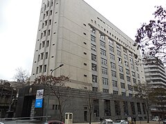
 National Administration of Fuels, Alcohol and Portland headquarters


-
 Artigas Teachers Institute
 -
 State Insurance Bank headquarters
 -
 Aguada neighbourhood


Landmarks
The main landmarks across this avenue are:
- Plaza Fabini
- Banco de Seguros del Estado
- Automóvil Club del Uruguay
- Edificio ANCAP
- Tiendas Introzzi
- Basílica Nuestra Señora del Carmen
- Instituto de Profesores Artigas
- Palacio Legislativo
References
- ^ "Desembarco de los Treinta y Tres Orientales | Ministerio de Educación y Cultura". 2021-04-26. Archived from the original on 2021-04-26. Retrieved 2022-03-27.
- ^ "Basílica Nuestra Señora del Carmen – Iglesia de La Aguada | Municipio B". 2022-03-16. Archived from the original on 2022-03-16. Retrieved 2022-03-27.
- ^ "AVENIDA LIBERTADOR | Montevideo Audiovisual". mvdaudiovisual.montevideo.gub.uy. Retrieved 2022-03-27.
- ^ "Nómada - Banco de Seguros del Estado". 2022-02-08. Archived from the original on 8 February 2022. Retrieved 2022-03-27.
- ^ "Nómada - ANCAP Edificio Central". 2022-03-08. Archived from the original on 8 March 2022. Retrieved 2022-03-27.
- ^ "IMM invirtió $ 35: en obras para mejorar el tránsito en el Parlamento - 29/01/2016 - EL PAÍS Uruguay". 2020-02-15. Archived from the original on 15 February 2020. Retrieved 2022-03-27.
- ^ "Monumento "España al Uruguay", obra del español José Clará. Plaza Isabel de Castilla, Avda. del Libertador, entre Galicia y La Paz, barrio Aguada, Montevideo, Uruguay | Mapio.net". 2020-10-27. Archived from the original on 2020-10-27. Retrieved 2022-03-27.
- ^ "Una recorrida histórica custodiada por jinetes y militantes eufóricos". 2020-03-06. Archived from the original on 6 March 2020. Retrieved 2022-03-27.
External links
Wikimedia Commons has media related to Avenida del Libertador, Montevideo.
- v
- t
- e
- 18 de Julio Avenue
- Uruguay Avenue
- Libertador Avenue
- Ejido Street


- Plaza Cagancha
- Plaza Fabini
- Plaza Isabel la Católica
- Palacio Rinaldi
- Jockey Club
- Edificio Lapido
- Palacio Brasil
- Palacio Uriarte de Heber
- Edificio Rex
- Edificio London París
- Palacio Chiarino
- Ateneo de Montevideo
- Palacio Montero
- Palacio Piria (Supreme Court)
- Palacio Santos (Ministry of Foreign Affairs)
- Edificio Confitería La Americana
- Edificio El Día (Casino Maroñas)
- Edificio Café Montevideo
- Palacio Díaz
- Mercado de la Ambundancia
- Palacio municipal
- Edificio Tapié
- Palacio Santa Lucia
- Casa Buxareo (French Embassy)
- Casa Pérsico
- Torre de los Profesionales
- Ministry of Economy
- ANCAP headquarters
- Tiendas Introzzi
- Museo del Gaucho
- Museo de la Moneda
- Subte Municipal
- Museo Pedagógico 'José Pedro Varela'
- Museo del Automovil
- SODRE Complex
- Sala Zitarrosa
- Teatro Circular de Montevideo
- Cine Teatro Plaza
- Sala Brunet
- Cinemateca 18
- Maroñas Entertainment
- Victoria Hall
- Four Points by Sheraton Montevideo
- Balmoral Plaza Hotel
- Holiday Inn Montevideo
- Hotel Crystal Palace, Montevideo
- Hotel Lafayette, Montevideo
- Hotel Oxford, Montevideo
34°54′11″S 56°11′35″W / 34.9031°S 56.1931°W / -34.9031; -56.1931
 | This Uruguayan road or road transport-related article is a stub. You can help Wikipedia by expanding it. |
- v
- t
- e
 | This Montevideo-related article is a stub. You can help Wikipedia by expanding it. |
- v
- t
- e


