Lenningen, Luxembourg
Commune in Remich, Luxembourg
Lenningen Lenneng | |
|---|---|
 | |
 Coat of arms | |
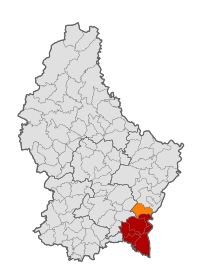 Map of Luxembourg with Lenningen highlighted in orange, and the canton in dark red | |
| Coordinates: 49°36′00″N 6°22′00″E / 49.6°N 6.3667°E / 49.6; 6.3667 | |
| Country |  Luxembourg Luxembourg |
| Canton | Remich |
| Area | |
| • Total | 20.35 km2 (7.86 sq mi) |
| • Rank | 57th of 100 |
| Highest elevation | 321 m (1,053 ft) |
| • Rank | 94th of 100 |
| Lowest elevation | 166 m (545 ft) |
| • Rank | 11th of 100 |
| Population (2023) | |
| • Total | 2,070 |
| • Rank | 76th of 100 |
| • Density | 100/km2 (260/sq mi) |
| • Rank | 66th of 100 |
| Time zone | UTC+1 (CET) |
| • Summer (DST) | UTC+2 (CEST) |
| LAU 2 | LU0001203 |
| Website | lenningen.lu |
Lenningen (Luxembourgish: Lenneng) is a commune and small town in southeastern Luxembourg. The commune has a population of about 1,900. It is located about 20 km east of the capital city, Luxembourg City. The commune's administrative centre is Canach.
As of 2013[update], the town of Lenningen, which lies in the east of the commune, has a population of 385.[1] The only other town within the commune is Canach.
Population
Graphs are unavailable due to technical issues. There is more info on Phabricator and on MediaWiki.org. |
References
- ^ La commune en chiffres Archived 2015-07-13 at the Wayback Machine - Lenningen Commune (in French)
- ^ "Population par canton et commune". statistiques.public.lu. Retrieved 11 January 2022.
External links
 Media related to Lenningen (Luxembourg) at Wikimedia Commons
Places adjacent to Lenningen, Luxembourg | ||||||||||||||||
|---|---|---|---|---|---|---|---|---|---|---|---|---|---|---|---|---|
| ||||||||||||||||


- v
- t
- e
| Authority control databases |
|
|---|
 | This article related to the geography of Remich canton is a stub. You can help Wikipedia by expanding it. |
- v
- t
- e


