Kopyly
Rural locality in Poltava Oblast, Ukraine
Village in Poltava Oblast, Ukraine
Kopyly Копили | |
|---|---|
Village | |
 Part of the village | |
49°33′33″N 34°36′49″E / 49.55917°N 34.61361°E / 49.55917; 34.61361 | |
| Country |  Ukraine Ukraine |
| Oblast |  Poltava Oblast Poltava Oblast |
| Raion |  Poltava Raion Poltava Raion |
| Village founded | ? |
| Area | |
| • Total | 2.974 km2 (1.148 sq mi) |
| Elevation | 91 m (299 ft) |
| Population (2001) | |
| • Total | 2,525 |
| • Density | 850/km2 (2,200/sq mi) |
| Time zone | UTC+2 (EET) |
| • Summer (DST) | UTC+3 (EEST) |
| Postal code | 38761 |
| Area code | +380 532 |
Kopyly (Ukrainian: Копили) is a village in Poltava Raion, Poltava Oblast, Ukraine. It belongs to Tereshky rural hromada, one of the hromadas of Ukraine.[1] The village has a population of 2,525.
The village is located 3 km southeast of Poltava, within Tereshky village council, at the E 40 chaussee and at the railway line Poltava—Krasnohrad. The largest body of water in the neighbourhood is Vorskla river. Its biggest tributary, the Kolomak, flows into it near the village.
-
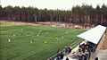 Suburban training field of FC Poltava

References
- ^ "Терешковская громада" (in Russian). Портал об'єднаних громад України.
External links
- Kopyly at the Verkhovna Rada of Ukraine site
- v
- t
- e
- Bilotserkivka
- Bilyky
- Chornukhy
- Chutove
- Drabynivka
- Dykanka
- Hadiach
- Hlobyne
- Hoholeve
- Horishni Plavni
- Hradyzk
- Hrebinka
- Kamiani Potoky
- Karlivka
- Khorol
- Kobeliaky
- Kolomatske
- Komyshnia
- Kotelva
- Kozelshchyna
- Krasna Luka
- Kremenchuk
- Lanna
- Liutenka
- Lokhvytsia
- Lubny
- Machukhy
- Martynivka
- Mashivka
- Mykhailivka
- Myrhorod
- Nekhvoroshcha
- Novo Haleshchyna
- Novi Sanzhary
- Novoorzhytske
- Novoselivka
- Obolon
- Omelnyk
- Opishnia
- Orzhytsia
- Petrivka-Romenska
- Pishchane
- Poltava
- Pryshyb
- Pyriatyn
- Reshetylivka
- Romodan
- Semenivka
- Sencha
- Serhiivka
- Shcherbani
- Shyshaky
- Skorokhodove
- Tereshky
- Velyka Bahachka
- Velyka Rublivka
- Velyki Budyshcha
- Velyki Sorochyntsi
- Zavodske
- Zinkiv
49°33′33″N 34°36′49″E / 49.55917°N 34.61361°E / 49.55917; 34.61361
 | This article about a location in Poltava Oblast is a stub. You can help Wikipedia by expanding it. |
- v
- t
- e


