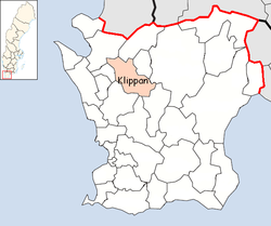
Klippan Municipality
Municipality in Skåne County, Sweden
Klippan Municipality Klippans kommun | |
|---|---|
Municipality | |
 | |
 Coat of arms | |
 | |
| Coordinates: 56°08′N 13°08′E / 56.133°N 13.133°E / 56.133; 13.133 | |
| Country | Sweden |
| County | Skåne County |
| Seat | Klippan |
| Area | |
| • Total | 379.41 km2 (146.49 sq mi) |
| • Land | 374.32 km2 (144.53 sq mi) |
| • Water | 5.09 km2 (1.97 sq mi) |
| Area as of 1 January 2014. | |
| Population (31 December 2023)[2] | |
| • Total | 17,723 |
| • Density | 47/km2 (120/sq mi) |
| Time zone | UTC+1 (CET) |
| • Summer (DST) | UTC+2 (CEST) |
| ISO 3166 code | SE |
| Province | Scania |
| Municipal code | 1276 |
| Website | www |
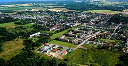
Klippan Municipality (Swedish: Klippans kommun) is a municipality in Skåne County in southern Sweden. Its seat is located in the town of Klippan.
The municipality was created in 1974 through the amalgamation of the market town Klippan (itself instituted in 1945) with the rural municipality of Riseberga and part of Östra Ljungby.
Söderåsen National Park is partly situated within the municipality.
Localities
There were five localities in the municipality in 2018.[3]
| Locality | Population |
|---|---|
| Klippan | 8,819 |
| Ljungbyhed | 2,168 |
| Östra Ljungby | 1,819 |
| Klippans bruk | 319 |
| Krika | 196 |
Demographics
This is a demographic table based on Klippan Municipality's electoral districts in the 2022 Swedish general election sourced from SVT's election platform, in turn taken from SCB official statistics.[4]
In total there were 17,742 residents, including 12,988 Swedish citizens of voting age.[4] 33.6% voted for the left coalition and 64.7% for the right coalition. Indicators are in percentage points except population totals and income.
| Location | Residents | Citizen adults | Left vote | Right vote | Employed | Swedish parents | Foreign heritage | Income SEK | Degree |
|---|---|---|---|---|---|---|---|---|---|
| % | % | ||||||||
| Klippan N-Gråmanstorp | 1,708 | 1,207 | 37.5 | 60.8 | 74 | 66 | 34 | 20,729 | 27 |
| Klippan NÖ-Solslätt | 1,680 | 1,202 | 37.0 | 62.0 | 78 | 73 | 27 | 23,484 | 29 |
| Klippan SÖ-Nyslätt | 2,266 | 1,667 | 35.9 | 61.8 | 71 | 73 | 27 | 20,850 | 23 |
| Klippan V | 2,107 | 1,496 | 37.4 | 60.5 | 70 | 64 | 36 | 19,950 | 26 |
| Krika-Bonnarp | 1,363 | 997 | 28.5 | 70.9 | 83 | 81 | 19 | 27,632 | 27 |
| Ljungbyhed N | 1,440 | 1,078 | 32.7 | 66.2 | 70 | 79 | 21 | 20,946 | 27 |
| Ljungbyhed S | 1,268 | 972 | 32.3 | 66.5 | 76 | 85 | 15 | 21,989 | 32 |
| Riseberga-Färingtofta | 1,258 | 986 | 34.1 | 64.6 | 77 | 84 | 16 | 23,404 | 37 |
| Stidsvig | 995 | 696 | 32.6 | 65.4 | 80 | 79 | 21 | 24,801 | 27 |
| Storäng-Vedby | 2,101 | 1,581 | 30.9 | 67.5 | 86 | 86 | 14 | 26,815 | 30 |
| Östra Ljungby | 1,556 | 1,106 | 29.0 | 69.0 | 78 | 79 | 21 | 23,065 | 23 |
| Source: SVT[4] | |||||||||
Buildings
The Church of St. Peter, designed by Sigurd Lewerentz, was completed in 1966.[5]
References
- ^ "Statistiska centralbyrån, Kommunarealer den 1 januari 2014" (in Swedish). Statistics Sweden. 2014-01-01. Archived from the original (Microsoft Excel) on 2016-09-27. Retrieved 2014-04-18.
- ^ "Folkmängd och befolkningsförändringar - Kvartal 4, 2023" (in Swedish). Statistics Sweden. February 22, 2024. Retrieved February 22, 2024.
- ^ "Folkmängd per tätort efter region och vart 5:e år" (in Swedish). Statistics Sweden. Retrieved 2019-08-07.[permanent dead link]
- ^ a b c "Valresultat 2022 för Klippan i riksdagsvalet" (in Swedish). SVT. 11 September 2022. Retrieved 6 January 2024.
- ^ Wilson, Colin St John (1988). "Sigurd Lewerentz and the Dilemma of the Classical". Perspecta. 24: 51–77.
External links
 Media related to Klippan Municipality at Wikimedia Commons
- Klippan Municipality - Official site
Places adjacent to Klippan Municipality | ||||||||||||||||
|---|---|---|---|---|---|---|---|---|---|---|---|---|---|---|---|---|
| ||||||||||||||||


Authority control databases | |
|---|---|
| International |
|
| National |
|
| Geographic |
|
 | This article about a location in Skåne County, Sweden is a stub. You can help Wikipedia by expanding it. |
- v
- t
- e


