Kerkdriel
Town in Gelderland, Netherlands

Flag

Coat of arms
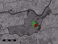
The town centre (red) and the statistical district (light green) of Kerkdriel in the municipality of Maasdriel.
(1 January 2019)
5331
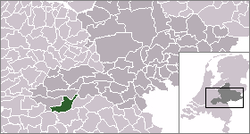
Kerkdriel is a town in the Dutch province of Gelderland. It is a part of the municipality of Maasdriel, and lies about 8 km north of 's-Hertogenbosch.
The town of Kerkdriel had 6,765 inhabitants, on 1 January 2019. The approximate built-up area of the town is 1.5 km2, and contains 2,835 residences.[1] The statistical area "Kerkdriel", which includes peripheral parts of the village, as well as the surrounding countryside, has a population of around 10,210.[1]
Due to its positioning between two rivers (Meuse and Waal), a strong local linguistic accent developed during the post second-world-war period. Those who speak the "Driels" accent may be identified via the test phrase "Kees de Beer" (proper: Keas d'n Bear).
References
- ^ a b Statistics Netherlands (CBS), Kerncijfers wijken en buurten in Nederland 2019. (Statistics are for the continuous built-up area).

Wikimedia Commons has media related to Kerkdriel.
- v
- t
- e
Populated places in the municipality of Maasdriel
- Kerkdriel
- Alem
- Ammerzoden
- Hedel
- Heerewaarden
- Hoenzadriel
- Hurwenen
- Rossum
- Velddriel
- Well
- Wellseind [nl]
| Authority control databases: Geographic |
|
|---|
 | This Gelderland location article is a stub. You can help Wikipedia by expanding it. |
- v
- t
- e


