Kallakoopah Creek
River in South Australia, Australia
| Kallakoopah | |
|---|---|
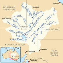 Map of the Lake Eyre Basin showing the Warburton River | |
| Location | |
| Country | Australia |
| State | South Australia |
| Region | Far North |
| Physical characteristics | |
| Source | Mount Gason |
| • elevation | 17 m (56 ft) |
| Mouth | Warburton River |
• coordinates | 27°29′S 138°15′E / 27.483°S 138.250°E / -27.483; 138.250 |
• elevation | −5 m (−16 ft) |
| Length | 353 km (219 mi) |
| Basin features | |
| River system | Lake Eyre Basin |
| Waterholes | Dunchadunchadinna, Kuncherinna, Anarowdinna, Kalanchadinna, Murdawadinna and Muckratuckaalinna |
| [1] | |
The Kallakoopah Creek, part of the Lake Eyre basin, is a watercourse located in the southern part of the Simpson Desert in the Australian state of South Australia. It is an anabranch of Warburton Creek.[2]
See also
 South Australia portal

References
- v
- t
- e
Rivers of South Australia
- Acraman
- Broughton
- Crystal
- Hill
- Hutt
- Rocky
- Bungala
- Christies
- Dry
- Field
- Panalatinga
- Gawler
- North Para
- Jacobs
- South Para
- North Para
- Glenelg
- Hindmarsh
- Inman
- Light
- Gilbert
- Little Para
- Myponga
- Onkaparinga
- Patawalonga
- Pirie–Torrens corridor
- Port
- Tod
- Torrens
- Wakefield
- Eyre
- Willochra Creek
- Calabrinda Creek
- Kanyaka Creek
This article about a river in South Australia is a stub. You can help Wikipedia by expanding it. |
- v
- t
- e


