Hradešice
Municipality in Plzeň, Czech Republic
49°19′24″N 13°35′47″E / 49.32333°N 13.59639°E / 49.32333; 13.59639 Czech Republic
 (2023-01-01)[1]
341 01
Hradešice is a municipality and village in Klatovy District in the Plzeň Region of the Czech Republic. It has about 400 inhabitants. The historic centre of the village is well preserved and is protected by law as a village monument zone.
Hradešice lies approximately 25 kilometres (16 mi) east of Klatovy, 50 km (31 mi) south of Plzeň, and 104 km (65 mi) south-west of Prague.
Administrative parts
The villages of Černíč and Smrkovec are administrative parts of Hradešice.
Demographics
| Year | Pop. | ±% |
|---|---|---|
| 1869 | 891 | — |
| 1880 | 951 | +6.7% |
| 1890 | 905 | −4.8% |
| 1900 | 866 | −4.3% |
| 1910 | 949 | +9.6% |
| 1921 | 931 | −1.9% |
| 1930 | 789 | −15.3% |
| 1950 | 655 | −17.0% |
| 1961 | 614 | −6.3% |
| 1970 | 561 | −8.6% |
| 1980 | 510 | −9.1% |
| 1991 | 457 | −10.4% |
| 2001 | 436 | −4.6% |
| 2011 | 404 | −7.3% |
| 2021 | 418 | +3.5% |
| Source: Censuses[2][3] | ||
Gallery
-
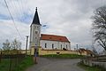 Church of the Transfiguration
 -
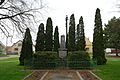 Monument to the victims of the world wars
 -
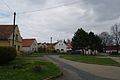 Centre of Hradešice


References
- ^ "Population of Municipalities – 1 January 2023". Czech Statistical Office. 2023-05-23.
- ^ "Historický lexikon obcí České republiky 1869–2011 – Okres Klatovy" (in Czech). Czech Statistical Office. 2015-12-21. pp. 11–12.
- ^ "Population Census 2021: Population by sex". Public Database. Czech Statistical Office. 2021-03-27.
External links
Wikimedia Commons has media related to Hradešice.
- Official website
- v
- t
- e
- Běhařov
- Běšiny
- Bezděkov
- Biřkov
- Bolešiny
- Břežany
- Budětice
- Bukovník
- Čachrov
- Černíkov
- Červené Poříčí
- Chanovice
- Chlistov
- Chudenice
- Chudenín
- Číhaň
- Čímice
- Dešenice
- Dlažov
- Dlouhá Ves
- Dobršín
- Dolany
- Domoraz
- Dražovice
- Frymburk
- Hamry
- Hartmanice
- Hejná
- Hlavňovice
- Hnačov
- Horažďovice
- Horská Kvilda
- Hrádek
- Hradešice
- Janovice nad Úhlavou
- Javor
- Ježovy
- Kašperské Hory
- Kejnice
- Klatovy
- Klenová
- Kolinec
- Kovčín
- Křenice
- Kvášňovice
- Lomec
- Malý Bor
- Maňovice
- Měčín
- Mezihoří
- Mlýnské Struhadlo
- Mochtín
- Modrava
- Mokrosuky
- Myslív
- Myslovice
- Nalžovské Hory
- Nehodiv
- Nezamyslice
- Nezdice na Šumavě
- Nýrsko
- Obytce
- Olšany
- Ostřetice
- Pačejov
- Petrovice u Sušice
- Plánice
- Podmokly
- Poleň
- Prášily
- Předslav
- Rabí
- Rejštejn
- Slatina
- Soběšice
- Srní
- Strašín
- Strážov
- Sušice
- Svéradice
- Švihov
- Tužice
- Týnec
- Újezd u Plánice
- Velhartice
- Velké Hydčice
- Velký Bor
- Vřeskovice
- Vrhaveč
- Zavlekov
- Zborovy
- Železná Ruda
- Žichovice
- Žihobce
| Authority control databases: National |
|
|---|
 | This Plzeň Region location article is a stub. You can help Wikipedia by expanding it. |
- v
- t
- e


