Hardyville, Kentucky
Unincorporated community in Kentucky, United States
Census-designated place in Kentucky, United States
37°15′15″N 85°47′10″W / 37.25417°N 85.78611°W / 37.25417; -85.78611 (2020)
42746
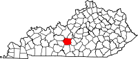
Hardyville is a small unincorporated community and census-designated place (CDP) in Hart County, Kentucky, United States, located east of Munfordville on U.S. Route 31E. As of the 2010 census it had a population of 156.[3] In the 2020 United States Census the population was 180.[4]
A post office was established in the community in 1868.[5] It was named in honor of a series of popular stump speeches given at the crossroads during the 1850s by local politician James Greene Hardy, Lieutenant Governor of Kentucky from 1855 to 1856.
Demographics
| Census | Pop. | Note | %± |
|---|---|---|---|
| 2020 | 155 | — | |
| U.S. Decennial Census[6] | |||
References
- ^ "2020 U.S. Gazetteer Files". United States Census Bureau. Retrieved March 18, 2022.
- ^ U.S. Geological Survey Geographic Names Information System: Hardyville, Kentucky
- ^ "Geographic Identifiers: 2010 Demographic Profile Data (G001): Hardyville CDP, Kentucky". American Factfinder. U.S. Census Bureau. Retrieved June 30, 2017.[dead link]
- ^ http://datausa.io/profile/geo/hardyville-ky/
- ^ Rennick, Robert M. (1987). Kentucky Place Names. University Press of Kentucky. pp. 131–132. ISBN 0813126312. Retrieved April 28, 2013.
- ^ "Census of Population and Housing". Census.gov. Retrieved June 4, 2016.
- v
- t
- e
Municipalities and communities of Hart County, Kentucky, United States
County seat: Munfordville
- Hardyville
unincorporated
communities
- Kentucky portal
- United States portal
 | This Hart County, Kentucky state location article is a stub. You can help Wikipedia by expanding it. |
- v
- t
- e


