Glottertal
You can help expand this article with text translated from the corresponding article in German. (February 2009) Click [show] for important translation instructions.
- View a machine-translated version of the German article.
- Machine translation, like DeepL or Google Translate, is a useful starting point for translations, but translators must revise errors as necessary and confirm that the translation is accurate, rather than simply copy-pasting machine-translated text into the English Wikipedia.
- Do not translate text that appears unreliable or low-quality. If possible, verify the text with references provided in the foreign-language article.
- You must provide copyright attribution in the edit summary accompanying your translation by providing an interlanguage link to the source of your translation. A model attribution edit summary is
Content in this edit is translated from the existing German Wikipedia article at [[:de:Glottertal]]; see its history for attribution. - You may also add the template
{{Translated|de|Glottertal}}to the talk page. - For more guidance, see Wikipedia:Translation.
Municipality in Baden-Württemberg, Germany

Coat of arms
Location of Glottertal within Breisgau-Hochschwarzwald district

(2022-12-31)[2]
79286
Glottertal is a municipality in the district of Breisgau-Hochschwarzwald in Baden-Württemberg in southern Germany.
History
From 1567 till the Napoleonic Wars the area was part of Further Austria and therefore part of the Habsburg monarchy. Although the history of mining in the Glottertal goes back to Roman times and villages in the area are mentioned 1112 in the chronics of Abbey of Saint Peter in the Black Forest the municipal Glottertal was formed in 1970. The four former independent villages Unterglottertal, Oberglottertal, Ohrensbach und Föhrental were associated to the Glottertal municipal.
Points of interest
Buildings

The 1914 built Carlsbau in Glottertal was the set for the 1980s medical drama television series The Black Forest Clinic. The outside of the building and the surrounding area was filmed while the interior was filmed in a set in Hamburg. The building was used as a clinic till it was closed down in 2004.[3][4]
Mining
The first archaeologic artefacts demonstrating iron smelting date back to the Roman time. The mining of silver started in the 11th century. The construction of a 15 kilometer long water channel to supply the mines with water do drive the pumps which was built in 1284 marks the importance of mining in the area. Flooding of the mines during a war period ended this activities at the end of the 12th century. The mining of silver continued on a smaller scale and in the 18th century the mining of iron and baryte was started. The last mines in the area closed before 1900.
Geography
The town is located in a small valley south east of the Kandel mountain. The valley opens to the west and the water of the small river Glotter reaches the Elz and little later the Rhine.
Gallery
-
 Glottertal, townhall
 -
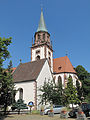 Glottertal, church: die Sankt Blasius Kirche
 -
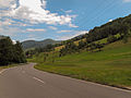 Between Glottertal and Sankt Peter, road panorama


External links
- Glottertal: picture (in German)
References
Wikimedia Commons has media related to Glottertal.
- ^ Bürgermeisterwahl Glottertal 2022, Staatsanzeiger.
- ^ "Bevölkerung nach Nationalität und Geschlecht am 31. Dezember 2022" [Population by nationality and sex as of December 31, 2022] (CSV) (in German). Statistisches Landesamt Baden-Württemberg. June 2023.
- ^ Stuff, Brita. Die Schwarzwaldklinik – Heile Welt zu verkaufen, Die Welt, August 22, 2009. Accessed March 5, 2010. (German)
- ^ Luck, Harry. Das Geisterhaus im Glottertal, Focus, August 24, 2007. Accessed March 5, 2010. (German)
- v
- t
- e
Towns and municipalities in Breisgau-Hochschwarzwald (district)
- Au
- Auggen
- Badenweiler
- Bad Krozingen
- Ballrechten-Dottingen
- Bötzingen
- Bollschweil
- Breisach
- Breitnau
- Buchenbach
- Buggingen
- Ebringen
- Ehrenkirchen
- Eichstetten am Kaiserstuhl
- Eisenbach
- Eschbach
- Feldberg
- Friedenweiler
- Glottertal
- Gottenheim
- Gundelfingen
- Hartheim am Rhein
- Heitersheim
- Heuweiler
- Hinterzarten
- Horben
- Ihringen
- Kirchzarten
- Lenzkirch
- Löffingen
- March
- Merdingen
- Merzhausen
- Müllheim
- Münstertal
- Neuenburg am Rhein
- Oberried
- Pfaffenweiler
- Schallstadt
- Schluchsee
- Sölden
- Sankt Märgen
- Sankt Peter
- Staufen
- Stegen
- Sulzburg
- Titisee-Neustadt
- Umkirch
- Vogtsburg
- Wittnau

Authority control databases | |
|---|---|
| International |
|
| National |
|
 | This Breisgau-Hochschwarzwald location article is a stub. You can help Wikipedia by expanding it. |
- v
- t
- e


