French Hainaut

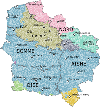
French Hainaut (French: Hainaut français [ɛno fʁɑ̃sɛ]) is one of two areas in France that form the département du Nord, making up its eastern part. It corresponds roughly with the Arrondissement of Avesnes-sur-Helpe (east), the Arrondissement of Cambrai (south-west) and the Arrondissement of Valenciennes (north-west).[1]
Until the 17th century, it was an integral part of the County of Hainaut, ruled by the House of Valois-Burgundy and later by the House of Habsburg. In a series of wars between France and Spain, this southern part of Hainaut was conquered by France, together with the adjacent Cambrésis, or Bishopric of Cambrai, to its south-west, and southern Flanders, which borders the English Channel, to its west. Together, these formed the French province of Flanders which, following the French Revolution, became the new Nord département.[1]
Picardy
Île-de-France
French Hainaut
Champagne
Other
References
- ^ a b Gilbert, of Mons (2005). Chronicle of Hainaut. Boydell Press. ISBN 978-1-84615-381-5.
- Gilbert of Mons, Chronicle of Hainaut, Boydell Press, 2005.
- v
- t
- e

- Alsace
- Angoumois
- Anjou
- Aquitaine
- Artois
- Aunis
- Auvergne
- Basse-Navarre
- Béarn
- Beaujolais
- Berry
- Bourbonnais
- Brittany
- Burgundy
- Cévennes
- Champagne
- Corsica
- Dauphiné
- Flanders
- Foix
- Forez
- Franche-Comté
- Gascony
- Gévaudan
- Guyenne
- Hainaut
- Île-de-France
- Languedoc
- Limousin
- Lorraine and Barrois
- Lyonnais
- Maine
- Marche
- Montbéliard
- Mulhouse
- Nice
- Nivernais
- Normandy
- Occitania
- Orléanais
- Perche
- Picardy
- Poitou
- Provence
- Roussillon
- Saintonge
- Savoy
- Touraine
- Trois-Évêchés
- Venaissin
- Vermandois

50°12′N 3°48′E / 50.20°N 3.80°E / 50.20; 3.80
| Authority control databases: National |
|
|---|


