Esgrus
You can help expand this article with text translated from the corresponding article in Danish. (June 2023) Click [show] for important translation instructions.
- Machine translation, like DeepL or Google Translate, is a useful starting point for translations, but translators must revise errors as necessary and confirm that the translation is accurate, rather than simply copy-pasting machine-translated text into the English Wikipedia.
- Do not translate text that appears unreliable or low-quality. If possible, verify the text with references provided in the foreign-language article.
- You must provide copyright attribution in the edit summary accompanying your translation by providing an interlanguage link to the source of your translation. A model attribution edit summary is
Content in this edit is translated from the existing Danish Wikipedia article at [[:da:Eskeris]]; see its history for attribution. - You may also add the template
{{Translated|da|Eskeris}}to the talk page. - For more guidance, see Wikipedia:Translation.
Municipality in Schleswig-Holstein, Germany

Coat of arms
Location of Esgrus
Eskeris within Schleswig-Flensburg district
Eskeris within Schleswig-Flensburg district

54°43′N 9°46′E / 54.717°N 9.767°E / 54.717; 9.767
(2022-12-31)[1]
24402
Esgrus (Danish: Eskeris) is a municipality in the district of Schleswig-Flensburg, in Schleswig-Holstein, Germany.
The municipality consists of the hamlet of Esgrus, where the church is located, and which gave the municipality its name, three villages - Wippendorf, Brunsholm and Esgrusschauby - and four other hamlets (Atzbüll, Birzhaft, Grünholz, Haveholz).[2] Esgrus is located in the northeast of Anglia, 6 km from the Gelting Bay and the Baltic Sea.
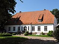
St. Mary's Church from the 12th century is one of the oldest fieldstone churches in Anglia. The Frauenhof estate is located in the southeast of the municipality. The representative three-sided farm can be reached via a picturesque alley with a half-timbered gatehouse. A second manor house is Brunsholmhof.
-
 St. Mary's Church
 -
 Frauenhof, Manor House with row of lime trees
 -
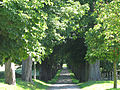 Frauenhof Alley
 -
 Frauenhof Thatchered Gate House
 -
 Brunsholmhof


References
- ^ "Bevölkerung der Gemeinden in Schleswig-Holstein 4. Quartal 2022" (XLS) (in German). Statistisches Amt für Hamburg und Schleswig-Holstein.
- ^ "DigitalerAtlasNord". DigitalerAtlasNord.
- v
- t
- e
Towns and municipalities in Schleswig-Flensburg
- Ahneby
- Alt Bennebek
- Arnis
- Ausacker
- Bergenhusen
- Böel
- Böklund
- Bollingstedt
- Boren
- Borgwedel
- Börm
- Böxlund
- Brodersby-Goltoft
- Busdorf
- Dannewerk
- Dollerup
- Dörpstedt
- Eggebek
- Ellingstedt
- Erfde
- Esgrus
- Fahrdorf
- Freienwill
- Gelting
- Geltorf
- Glücksburg
- Grödersby
- Groß Rheide
- Großenwiehe
- Großsolt
- Grundhof
- Handewitt
- Harrislee
- Hasselberg
- Havetoft
- Hollingstedt
- Holt
- Hörup
- Hürup
- Husby
- Hüsby
- Idstedt
- Jagel
- Janneby
- Jardelund
- Jerrishoe
- Jörl
- Jübek
- Kappeln
- Klappholz
- Klein Bennebek
- Klein Rheide
- Kronsgaard
- Kropp
- Langballig
- Langstedt
- Lindewitt
- Loit
- Lottorf
- Lürschau
- Maasholm
- Medelby
- Meggerdorf
- Meyn
- Mittelangeln
- Mohrkirch
- Munkbrarup
- Neuberend
- Nieby
- Niesgrau
- Norderbrarup
- Nordhackstedt
- Nottfeld
- Nübel
- Oersberg
- Oeversee
- Osterby
- Pommerby
- Rabel
- Rabenholz
- Rabenkirchen-Faulück
- Ringsberg
- Rügge
- Saustrup
- Schaalby
- Schafflund
- Scheggerott
- Schleswig
- Schnarup-Thumby
- Schuby
- Selk
- Sieverstedt
- Silberstedt
- Sollerup
- Sörup
- Stangheck
- Stapel
- Steinberg
- Steinbergkirche
- Steinfeld
- Sterup
- Stolk
- Stoltebüll
- Struxdorf
- Süderbrarup
- Süderfahrenstedt
- Süderhackstedt
- Taarstedt
- Tarp
- Tetenhusen
- Tielen
- Tolk
- Treia
- Twedt
- Uelsby
- Ulsnis
- Wagersrott
- Wallsbüll
- Wanderup
- Wees
- Weesby
- Westerholz
- Wohlde

Authority control databases | |
|---|---|
| International |
|
| National |
|
 | This Schleswig-Flensburg location article is a stub. You can help Wikipedia by expanding it. |
- v
- t
- e


