Echo Bridge
United States historic place
Echo Bridge | |
U.S. Historic district Contributing property | |
 Echo Bridge | |
| Location | Spans the Charles River between Needham and Newton, Massachusetts, U.S. |
|---|---|
| Coordinates | 42°18′53.42″N 71°13′36.84″W / 42.3148389°N 71.2269000°W / 42.3148389; -71.2269000 |
| Built | 1876 |
| Architect | George W. Phelps |
| Part of | Sudbury Aqueduct Linear District (#89002293) Newton Upper Falls Historic District (#86001750) |
| NRHP reference No. | 80000638 [1] |
| Significant dates | |
| Added to NRHP | April 9, 1980 |
| Designated CP | January 18, 1990 September 4, 1986 |
Echo Bridge is a historic masonry bridge spanning the Charles River between Needham to Newton Upper Falls, Massachusetts, and Ellis Street in Newton. The bridge carries the Sudbury Aqueduct and foot traffic, and is located in the Hemlock Gorge Reservation. At the time of its construction in 1875–1877, it was the second longest masonry arch in the country.
The bridge was listed on the National Register of Historic Places in 1980, and was named an American Water Landmark in 1981.
Description
The bridge crosses over Hemlock Gorge where the Charles River passes over the fall line in Newton Upper Falls. There are still old mill buildings in view from the bridge, but most of the gorge remains naturally overgrown with hemlocks. The bridge has two viewing locations, the pedestrian walk on top of the bridge and a platform underneath where visitors can hear the eponymous echoes. Views include white water, a waterfall and the hemlock-lined gorge. The 23-acre (93,000 m2) Hemlock Gorge Reservation including the gorge is maintained by the Massachusetts Department of Conservation and Recreation. The bridge is located just off Route 9 where it crosses Route 128. Despite being in the midst of a tangle of highways, the river itself is tree-lined and natural.
The bridge is 500 feet (150 m) long, and consists of a series of seven arches. The longest of these, that crosses the Charles, has a span of 137 feet (42 m), and is a segmented arch with a radius of 69 feet (21 m) and a crown of 51 feet (16 m). Five of the arches span 37 feet (11 m), while that spanning Ellis Street is 28 feet (8.5 m). At its crown the bridge is approximately 70 feet (21 m) above the river. The bridge's foundations are made of granite resting on bedrock.[2]
The bridge was closed to the public for much of 2006 to permit repairs of the railings, which were decaying and which do not meet modern safety codes.[3] Because of the cost of rebuilding the historic railings, chain link fencing was installed on each side, allowing the bridge to be reopened. This fencing was later replaced by a set of modern railings inside the historic railings. Efforts are underway to secure funding to reconstruct the historic railings.[4]
-
 Walkers on the bridge before it was closed for railing repairs in 2006
 -
 The bridge closed for repairs
 -
 The bridge reopened with temporary protective fencing
 -
 Protective railings next to the historic railings


The aqueduct, which has been serving only as an emergency backup for some years, was reactivated during a state of emergency declared on May 1, 2010. The line was used to carry clean water to parts of 38 communities affected by a catastrophic failure elsewhere in the MWRA system.
Photo gallery
-
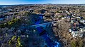 Aerial view of the bridge and Hemlock Gorge
 -
 Winter view from upstream
 -
 Spring view from downstream
 -
 The Silk Mill Dam, viewed from Echo Bridge
 -
 The bridge from the "echo platform" on the Newton side


See also
- List of bridges documented by the Historic American Engineering Record in Massachusetts
- National Register of Historic Places listings in Newton, Massachusetts
- National Register of Historic Places listings in Norfolk County, Massachusetts
References
- ^ "National Register Information System". National Register of Historic Places. National Park Service. January 23, 2007.
- ^ "NRHP nomination for Echo Bridge". Commonwealth of Massachusetts. Retrieved April 10, 2014.
- ^ "Echo Bridge Railings Reconstruction". Retrieved July 2, 2021.
- ^ Fisher, Lee. "Call-to-Action: Support Echo Bridge Railing Reconstruction Today" (PDF). Newton Conservators. Retrieved July 2, 2021.
External links
Wikimedia Commons has media related to Echo Bridge.
- The Friends of Hemlock Gorge
- Hemlock Gorge Reservation Newton Conservators
- The science behind the arch's echo
- Echo Bridge at Structurae
- Historic American Engineering Record (HAER) No. MA-39, "Sudbury River Aqueduct, Echo Bridge, Spanning Charles River at Upper Newton Falls, Newton, Middlesex County, MA", 4 photos, 1 data page, 1 photo caption page
- U.S. Geological Survey Geographic Names Information System: Echo Bridge
- v
- t
- e

| Barnstable County | |
|---|---|
| Bristol County | |
| Essex County | |
| Hampden County | |
| Middlesex County | |
| Norfolk County | |
| Suffolk County | |
| Worcester County |
 Category
 National Register of Historic Places portal
 United States portal


| Authority control databases: Geographic |
|
|---|


