Dunbar Islands
62°28′10″S 60°10′40″W / 62.46944°S 60.17778°W / -62.46944; -60.17778
The Dunbar Islands are a small group of islands lying off Varna Peninsula southwest of Williams Point, the northeast extremity of Livingston Island in the South Shetland Islands, Antarctica comprising the islands of Aspis, Balsha, Melyane, Pogledets and Zavala, and several minor islets and rocks. The area was visited by early 19th century sealers.
The islands are named after Captain Thomas Dunbar, Master of the American sealing schooner Free Gift which visited the South Shetland Islands in 1820–21.
Location
The midpoint of the group is located at 62°28′10″S 60°10′40″W / 62.46944°S 60.17778°W / -62.46944; -60.17778 (British mapping in 1968, Spanish in 1991, and Bulgarian in 2005 and 2009).
Maps
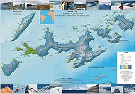
- L.L. Ivanov et al. Antarctica: Livingston Island and Greenwich Island, South Shetland Islands. Scale 1:100000 topographic map. Sofia: Antarctic Place-names Commission of Bulgaria, 2005.
- L.L. Ivanov. Antarctica: Livingston Island and Greenwich, Robert, Snow and Smith Islands. Scale 1:120000 topographic map. Troyan: Manfred Wörner Foundation, 2009. ISBN 978-954-92032-6-4
See also
- Composite Antarctic Gazetteer
- List of Antarctic islands south of 60° S
- SCAR
- Territorial claims in Antarctica
External links
- SCAR Composite Antarctic Gazetteer.

Portals:
 Islands
 Geography


- v
- t
- e
- Clarence
- Deception
- Elephant
- Greenwich
- King George
- Livingston
- Low
- Nelson
- Robert
- Smith
- Snow
- Afala
- Aitcho
- Akin
- Alfeus
- Araguez
- Astor
- Aurelia
- Barlow
- Basso
- Beslen
- Biruni
- Boatin
- Borceguí
- Bridgeman
- Cacho
- Chiprovtsi
- Cornwall
- Cornwallis
- Craggy
- Dee
- Desolation Island (South Shetland Islands)
- Dinea
- Dioptra
- Dufayel
- Dunbar
- Eadie
- Express
- Fregata
- Gergini
- Gibbs
- Glumche
- Gnomon
- González
- Half Moon
- Heywood
- Kabile
- Kaliman
- Kondor
- Korsis
- Låvebrua
- Meade
- Miladinovi
- Montufar
- Ogygia
- Ongley
- Onogur
- Penguin
- Pindarev
- Pordim
- Presnakov
- Prisad
- Prosechen
- Pyramid
- Rogozen
- Romeo
- Rotalia
- Rowett
- Rugged
- Saffar
- San Telmo
- Seal
- Sierra
- Square End
- Stoker
- Sugarloaf
- Table
- Tatul
- Tirizis
- Toledo
- Treklyano
- Two Summit
- Valchedram
- Window
- Withem
- Wood
- Yrvind
- Zebil
- Zed
Rocks, stacks, reefs
spits and banks
spits and banks
- Aim Rocks
- Alepu
- Avren
- Baktriana
- Ballestilla
- Bekas
- Belchin
- Besson
- Bizone
- Bonert
- Borda
- Bowler
- Brahe
- Bris
- Buchino
- Caraquet
- Chabrier
- Channel
- Chaos
- Chapman
- Cheshire
- Chorobates
- Cone
- Cosmolabe
- Cove
- Cutler
- Dlagnya
- Dovizio
- Dzhegov
- Eddystone
- Elemag
- Eliza
- Emm
- Enchantress
- Folger
- Frederick
- Galiche
- Goritsa
- Grace
- Graovo
- Groma
- Growler
- Habermehl
- Hauken
- Henfield
- Hetty
- Hole
- Holmes
- Ibar
- Indian
- Keep
- Kianida
- Knight
- Koynare
- Lenoir
- Letelier
- Liberty
- Lientur
- Limit
- Livonia
- Long
- Low
- Lynx
- Lyutibrod
- Maglizh
- Makresh
- Martello Tower
- Meldia
- Mellona
- Milev
- Mónica
- Morris
- Nancy
- Napier
- Nessie
- Nikudin
- Odometer
- Okol
- Opaka
- Ørnen
- Orsini
- Orsoya
- Parry Patch
- Passage
- Patresh
- Perivol
- Pig
- Pingvin
- Potmess
- Asses Ears
- Priboy
- Rabisha
- Ramsden
- Raquelia
- Reyes
- Ritchie
- Rongel
- Rosales
- Rusokastro
- Sail Rock
- Salient
- Sally
- Sewing-Machine Needles
- Shearer
- Simms
- Simpson
- Sinbad
- Skrino
- Stackpole
- Stewart
- Suhache
- Syrezol
- Telefon
- Telish
- Tenorio
- The Pointers
- Tooth
- Triznatsi
- Troughton
- Tu
- Turmoil
- Tvarditsa
- Twin Pinnacles
- Upton
- Vardim
- Vergilov
- Vidal
- Vietor
- Vodoley
- Voluyak
- Waldseemüller
- Weeks
Undersea and
subglacial features
subglacial features
| ||||||||
|---|---|---|---|---|---|---|---|---|
| Geography |
|  | ||||||
| History | ||||||||
| Politics | ||||||||
| Society | ||||||||
| Famous explorers | ||||||||
| ||||||||

 | This Livingston Island location article is a stub. You can help Wikipedia by expanding it. |
- v
- t
- e


