Duke of York Island, Papua New Guinea
Island in Papua New Guinea
 | |
 | |
| Administration | |
|---|---|
Papua New Guinea |

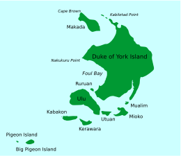
Duke of York Island is the largest island of Duke of York Islands, Papua New Guinea, at 4°10′00″S 152°28′00″E / 4.1666667°S 152.4666667°E / -4.1666667; 152.4666667.[1] The island is named after Prince Frederick, the second son of King George III of Great Britain.[2]
There is also a Duke of York Island at 71°37′33.74″S 170°2′56.88″E / 71.6260389°S 170.0491333°E / -71.6260389; 170.0491333 in North Victoria Land in East-Antarctica, at the southern end of Robertson Bay, not far from Cape Adare.[3][4]
References
- ^ "Duke of York Group | Melanesian, Yule & Mussau | Britannica". www.britannica.com. Retrieved 9 February 2024.
- ^ "Island immersion: a visit to the Duke of York Islands". Business Advantage PNG. 9 December 2023. Archived from the original on 19 January 2024. Retrieved 9 February 2024.
- ^ "Antarctica Detail". 2 June 2021. Archived from the original on 2 June 2021. Retrieved 9 February 2024.
- ^ "BirdLife Data Zone". datazone.birdlife.org. Retrieved 9 February 2024.
- v
- t
- e
Islands of Papua New Guinea
- Admiralty Islands
- Ali
- Ambitle
- Aua
- Auriroa
- Bam
- Baudisson
- Bougainville
- Bagabag
- Bagaman
- Babase
- Baluan
- Barahun
- Basilaki
- Big Ndrova
- Bipi
- Bismarck Archipelago
- Blup Blup
- Boagis
- Boang
- Bonvouloir Islands
- Brumer
- Buka
- Calvados Chain
- Carteret Islands
- Conflict Group
- D'Entrecasteaux Islands
- Daloloia Group
- Dart Reefs
- Daru
- Deboyne Islands
- Dobu
- Duchateau Islands
- Duke of York Island / Duke of York Islands
- Dyaul
- East
- Emirau
- Feni Islands
- Fergusson
- Goaribari
- Gonubalabala Island
- Goodenough
- Green Islands
- Gulowa
- Hastings
- Hemenahei
- Hermit Islands
- Kabakon
- Kaniet Islands
- Karkar
- Kadovar
- Kerawara
- Kiriwina
- Kiwai
- Kui
- Kuwanak
- Lihir Island / Lihir Group
- Lif
- Little Ndrova
- Long
- Los Negros
- Lou
- Louisiade Archipelago
- Lunn Island
- Madau
- Mailu
- Malendok
- Makada
- Manam
- Manne
- Manus
- Marshall Bennett
- Mioko
- Misima
- Motorina
- Mualim
- Mussau
- Mut Mut
- New Britain
- New Hanover
- New Guinea
- New Ireland
- Ninigo Islands
- Nissan
- Normanby
- North Solomon Islands
- Nuakata
- Nubara
- Nukumanu
- Nusam
- Pak
- Pam Islands
- Panapompom Islands
- Pana Tinani
- Panaeati
- Panarairai Island
- Panatinane
- Pana Wina Island
- Patio
- Pinipel
- Pocklington Reef
- Purdy
- Purutu
- Rambutyo
- Renard Islands
- Ritter
- Rossel (Yela)
- Sae
- Sakar
- Samarai
- Sanaroa
- Schouten Islands
- Selapiu
- Seleo
- Sideia
- Simberi
- Sirot
- St. Andrews Islands
- St Matthias Islands
- Strathord Islands
- Sudest
- Tabar Group
- Tabar
- Takuu
- Tanga Islands
- Tatau
- Tefa
- Tolokiwa
- Tong
- Trobriands
- Tsoilaunung
- Tumleo
- Ulu
- Umboi
- Unea
- Utian
- Vanatinai
- Vial
- Vitu Islands
- Wabuda
- Wagifa
- Western Islands
- Woodlark
- Wuvulu
- Yeina
- Yule
 Islands portal
 | This Papua New Guinea–related geography article is a stub. You can help Wikipedia by expanding it. |
- v
- t
- e


