Severe Tropical Cyclone Keli (NPMOC/JTWC Designation: 38P) was the first recorded post-season tropical cyclone to form in June within the South Pacific Ocean. The system formed on June 7, 1997, about 460 kilometers (285 mi) to the north of Tokelau. The depression gradually developed over the next few days while moving southwestward. It was designated as Tropical Cyclone Keli early the next day. Cyclone Keli intensified, slowly reaching its 10-minute peak wind speeds of 150 km/h (90 mph), which made it a Category 3 severe tropical cyclone on the Australian Tropical Cyclone Intensity Scale. As it came under the influence of strong mid latitude westerlies and moved into an area of strong vertical wind shear, the cyclone started to weaken and was declared extratropical on June 15.
Cyclone Keli struck the islands of Tuvalu on June 12 and 13, with extensive damage reported throughout the Islands with trees uprooted by wind and waves. On Nivalakita, all buildings except for the church were flattened; an estimated cost to rebuild all of the houses as they were before the cyclone hit was estimated at A$12,000 (US$10,000), while it was estimated that the cost of rebuilding the houses with an improved, cyclone-resistant design would be about A$84,000 (US$63,000). The whole of Tepuka Savilivili was left uninhabitable, as coconut trees and other vegetation were swept away with no more than an area of jagged coral left behind. In Fiji, strong winds and rough seas were reported from the cyclone as it was moving to the north of Fiji, and while the cyclone was weakening it dropped 3.76 inches (95.5mm) of rain on American Samoa.
During June 7, the Fiji Meteorological Service (FMS) reported that a weak tropical low had emerged from the South Pacific Convergence Zone, to the northeast of the New Zealand territory of Tokelau.[1][2] Over the next couple of days, the low gradually developed further as it was steered slowly westwards by mid-level easterly winds, into an area of strong upper-level diffulence and an abnormal area of high sea-surface temperatures.[1] During June 9, the United States Naval Pacific Meteorology and Oceanography Center (NPMOC) issued a tropical cyclone formation alert for the system, before they initiated advisories on the system and designated it as Tropical Cyclone 38P at 00:00 UTC (12:00 Tuvalu Time (TVT)) on June 10.[3][4] Six hours later, the FMS named the system Keli after it had developed into a category 1 tropical cyclone on the Australian tropical cyclone intensity scale, while it was located about 335 km (205 mi) to the northeast of the island of Niulakita in Tuvalu.[1][5][6] After being named, the system moved south-westwards towards Niulakita as it continued to gradually intensify becoming a category 2 tropical cyclone, before it passed just to the north of the island at about 03:00 UTC (15:00 TVT) on June 11.[1][2][7] As Keli approached Niulakita, its general movement slowed down and it performed a clockwise cyclonic loop to the north of the island, while a mid-level trough of low pressure approached the system from the west.[1][8] As a result of its slow movement keeping the system in an area of low vertical windshear, Keli continued to intensify with a cloud-filled eye appearing on satellite imagery.[1][9]
During June 12, the system accelerated south-eastwards and started to pose a threat to the French territory of Wallis and Futuna as it passed in between Niulakita and Nukulaelae.[1][6][9] Later that day, at about 06:00 UTC (18:00 TVT), the FMS estimated that Keli had peaked in intensity as a category 3 severe tropical cyclone, with 10-minute sustained winds of 150 km/h (90 mph).[2][10] Twelve hours later, the NPMOC reported that Keli had peaked with 1-minute sustained wind speeds of 215 km/h (130 mph), which made it equivalent to a Category 4 hurricane on the Saffir-Simpson hurricane wind scale.[2][11] After it had peaked in intensity, Keli encountered higher levels of vertical windshear which caused it to start to weaken and transition into an extratropical cyclone, before it passed about 55 km (35 mi) to the west of Wallis during June 13.[1][6][12] After the system had passed to the west of Wallis, Keli continued to move south-eastwards and weakened into a category 2 tropical cyclone, before it passed about 110 km (70 mi) to the north of Niuatoputopu in northern Tonga and 175 km (110 mi) to the northeast of the island nation of Niue during June 14.[1][2] During the following day, the NPMOC reported that the system had degenerated into extratropical cyclone and issued their final advisory before the FMS reported that Keli had degenerated into a tropical depression, while it was located about 370 km (230 mi) to the west of Rarotonga in the Cook Islands.[10][13] Later that day, the system's remnants passed near the island of Mauke in the Southern Cook Islands at about 12:00 UTC (02:00 Cook Islands Time), before they were last noted by New Zealand's MetService during June 17, as they moved past 120°W about 2140 km (1330 mi) to the southeast of Adamstown in the Pitcairn Islands.[1][2][6]
Effects
The name Keli was retired after this usage of the name and was replaced with the name Kofi.[14]
Tuvalu
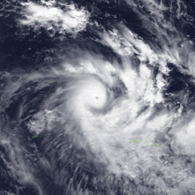
Image of Keli at peak intensity on June 12, 1997
Keli was the third tropical cyclone to impact Tuvalu during the 1996-97 cyclone season after Severe Tropical Cyclones Gavin and Hina impacted the island nation in March 1997.[1][15] Ahead of the system impacting Tuvalu, storm and gale-force wind warnings were issued for the islands of Niulakita and Nukulaelae, while a strong wind warning was issued for the rest of the group during June 10.[7] During that day the system moved south-westwards and passed near or over Niulakita later that day, before it performed a cyclonic loop and passed within 65 km (40 mi) of Niulakita during June 12.[7]
As Cyclone Keli struck the islands of Tuvalu on June 12 and 13, peak wind gusts of 165 km/h (105 mph) were reported, with extensive damage also reported throughout the Islands with trees uprooted by wind and waves.[16] On Nivalakita all buildings except for the church were flattened with an estimated cost to rebuild the houses exactly as they were was estimated at A$12,000 (US$10,000 1997), while it was estimated that the cost of rebuilding the houses with an improved, cyclone-resistant design would be about A$84,000 (US$63,000 1997).[17] Also on Nivalakita communications were cut with the telephone operator having to resort to sending a Morse code message, however as the storm re-curved and re-hit Tuvalu on June 14, it silenced the weak radio telegraph system.[16] In Tepuka Savilivili the whole island was left uninhabitable as coconut trees and other vegetation were swept away with no more than an area of jagged coral left behind.[18][19][20][21]
As a result of limited food supplies on Funafuti for the island nation, the then Governor General Sir Tulaga Manuella declared Tuvalu to be under a state of public of emergency with effect from June 12.[7] This enabled the High Commission of Tuvalu in Suva, Fiji to appeal to the governments of Australia, New Zealand, United Kingdom, France, Korea amongst others, as well as the United Nations Development Programme for aid.[7] Officials from the Governments of Australia, France and New Zealand subsequently collaborated and worked out what assistance could be provided, before the Royal New Zealand Air Force deployed a transport plane during June 14, which contained tarpaulins, water containers, food, clothing, and medical supplies.[22] The plane's crew subsequently conducted an aerial assessment of the damage on Niulakita and reported seeing widespread damage, before they arrived at Funafuti Airport on June 15.[7][23]
Wallis and Futuna
Cyclone Keli was the third out of four tropical cyclones to impact the French Territory of Wallis and Futuna during a ten-month period, after Cyclones Gavin and Hina had affected the island during March 1997.[1][24][25] There was almost no damage recorded in the archipelago from Keli, while rainfall totals of 171.6 mm (6.76 in) and 160 mm (6.3 in) were recorded at Hihifo and Aka'aka on Wallis during June 11.[24] Wind gusts of up to 70 km/h (45 mph) were recorded at Maopoopo on Futuna island during July 13.[24]
Samoan Islands
A rainfall total of 160 mm (6.3 in) was reported at Afono in American Samoa.[26]
Tonga
Keli was the second of three tropical cyclones to affect Tonga during a ten-month period, with Cyclones Hina and Ron affecting the island nation during March 1997 and January 1998.[27] Ahead of the system impacting Tonga, the FMS issued cyclone warnings for the Niuas and strong wind warnings for the rest of Tonga.[28] As a result of the warnings a vessel that was heading to the island group had to be recalled, which was predicted to affect supplies on the islands when it was likely to be most needed.[28] During June 13, Keli caused some damage to the islands with plantations, breadfruit trees and other large trees devastated.[28] The strong winds also destroyed several residences while causing damage to public buildings.[28]
Niue
Keli was the first and only tropical cyclone to impact the island of Niue during the 1996-97 season, as it moved south-eastwards and weakened into a tropical depression between June 13 - 15.[29] On the island, an average windspeed of 46 km/h (29 mph), momentary wind gusts of 74 km/h (46 mph) and a rainfall total of 66.2 mm (2.61 in) were reported on the island.[29] The strong winds were mainly felt in the eastern, northern and western villages where residents were blown over, while several banana and coconut trees were blown down.[29]
^ abcdefghijklFiji Meteorological Service (September 1998). Final Report of the Seventh Session: Appendix IV: Tropical Cyclone Seasonal Summary 1996-97. RA V Tropical Cyclone Committee for the South Pacific and the South-East Indian Ocean Seventh Session. World Meteorological Organization.
^ abcdef"1997 Tropical Cyclone Keli (1997156S11192)". International Best Track Archive for Climate Stewardship. Retrieved October 2, 2023.
^Tropical Cyclone Formation Alert June 9, 1997 11z (Report). United States Naval Pacific Meteorology and Oceanography Center. June 9, 1997. Archived from the original on November 9, 2013. Retrieved October 2, 2023.
^Tropical Cyclone 38P (Keli) Warning 1; June 10, 1997 03z (Report). United States Naval Pacific Meteorology and Oceanography Center. June 10, 1997. Archived from the original on November 9, 2013. Retrieved October 2, 2023.
^Darwin Tropical Diagnostic Statement: June 1997 (PDF) (Report). Vol. 16. Australian Bureau of Meteorology. 1997. p. 2. ISSN 1321-4233. Archived from the original (PDF) on December 11, 2017. Retrieved October 10, 2015.
^ abcd"Saison des perturbations tropicales: 1996-1997 Pacifique sud-ouest: Une saison particulièrement longue". Météorologie Maritime (in French). No. 178. 1998. pp. 24–29. ISSN 2107-0830.
^ abcdefDamage Assessment Team (1997). Tropical Cyclone Keli: June 10 - 13, 1997, Report on the extent of damage (PDF) (Report). Tuvalu National Disaster Committee. Archived (PDF) from the original on October 17, 2023. Retrieved October 17, 2023.
^Tropical Cyclone 38P (Keli) Warning 4; June 11, 1997 15z (Report). United States Joint Typhoon Warning Center. June 11, 1997. Archived from the original on November 9, 2013. Retrieved October 17, 2023.
^ abTropical Cyclone 38P (Keli) Warning 6; June 12, 1997 15z (Report). United States Joint Typhoon Warning Center. June 12, 1997. Archived from the original on November 9, 2013. Retrieved October 17, 2023.
^ abHanstrum, Barry N; Reader, Grahame; Bate, Peter W (September 3, 1999). "The South Pacific and Southeast Indian Ocean Tropical Cyclone Season 1996–97" (PDF). Australian Meteorological Magazine. 48 (3): 209–210. Archived (PDF) from the original on March 21, 2012. Retrieved August 8, 2013.
^"4. Summary of South Pacific and South Indian Ocean Tropical Cyclones". Annual Tropical Cyclone Report: 1997 (PDF) (Report). United States Joint Typhoon Warning Center. 1998. pp. 132 — 142 (179 — 189). Archived from the original (PDF) on October 20, 2020. Retrieved October 17, 2023.
^Tropical Cyclone 38P (Keli) Warning 8; June 13, 1997 15z (Report). United States Naval Pacific Meteorology and Oceanography Center. June 13, 1997. Archived from the original on November 9, 2013. Retrieved October 10, 2015.
^Tropical Cyclone 38P (Keli) Warning 11; June 15, 1997 03z (Report). United States Naval Pacific Meteorology and Oceanography Center. June 15, 1997. Archived from the original on November 9, 2013. Retrieved October 2, 2023.
^RA V Tropical Cyclone Committee (2023). Tropical Cyclone Operational Plan for the South-East Indian Ocean and the Southern Pacific Ocean 2023 (PDF) (Report). World Meteorological Organization. Retrieved October 23, 2023.
^"Country Risk Profile: Tuvalu" (PDF). The Pacific Catastrophe Risk Assessment and Financing Initiative. September 2011. p. 3. Archived from the original (PDF) on October 6, 2013. Retrieved August 7, 2013.
^ abSteve Newman (June 24, 1997). "EARTHWEEK: A diary of the planet". The Gainesville Sun. Retrieved August 30, 2009.
^Emily M (March 17, 2006). "Tool One: Guidelines for estimating the economic impact of natural disasters" (PDF). Aus Aid. Archived from the original (PDF) on September 30, 2009. Retrieved August 30, 2009.
^Bikenibeu Paeniu (December 7, 1997). "Tuvalu and Global Warming". Tuvalu Islands. Retrieved August 30, 2009.
^Angie Knox (August 28, 2002). "Sinking feeling in Tuvalu". BBC News. Retrieved August 30, 2009.
^"Neighbours fly aid to cyclone-hit island in South Pacific". The Associated Press. June 14, 1997.
^"Damage still undetermined on cyclone-hit Tuvalu". The Associated Press. June 15, 1997. Archived from the original on March 4, 2016. Retrieved October 10, 2015.
^McKinnon, Donald C, Minister of Foreign Affairs and Trade (June 17, 1997). "Questions for Oral Answer: Questions to Ministers: Tuvalu Cyclone: New Zealand's Response". Parliamentary Debates (Hansard). Vol. 561. New Zealand: House of Representatives. col. 11.
^"New Zealand crew reports widespread damage on Tuvalu atoll". Wellington, New Zealand. The Associated Press. June 16, 1997.
^ abc"Wallis and Futuna Cyclone Passes De 1880 à nos jours" [Wallis and Futuna Cyclone Passes From 1880 to the present day] (in French). Meteo France New Caledonia. Retrieved January 2, 2017.
^"Cyclone Keli might force a cancellation of Saturday's". Agence France Presse. June 14, 1997. – via Lexis Nexis (subscription required)
^Roth, David M. (January 3, 2023). "Tropical Cyclone Point Maxima". Tropical Cyclone Rainfall Data. United States Weather Prediction Center. Retrieved January 6, 2023. This article incorporates text from this source, which is in the public domain.
^A report on the list of the tropical cyclones that has affected at least a part of Tonga from 1960 to Present (PDF) (Report). Tonga Meteorological Service. Retrieved January 2, 2014.
^ abcd"In the Eye of the Storm, A nation in waiting". Island Snapshot. June 12, 1997. Archived from the original on March 4, 2016. Retrieved October 11, 2015.
^ abcFinal Report of the Seventh Session: Appendix VI-6: Niue. RA V Tropical Cyclone Committee for the South Pacific and the South-East Indian Ocean Seventh Session. World Meteorological Organization. September 1998.


 Extratropical cyclone, remnant low, tropical disturbance, or monsoon depression


