Severe Tropical Cyclone Jasper was the wettest tropical cyclone in Australian history, surpassing Cyclone Peter of 1979.[2] The third disturbance of the 2023–24 South Pacific cyclone season and the first named storm and severe tropical cyclone of the 2023–24 Australian region cyclone season, Jasper was first noted as an area of low pressure located in the South Pacific Ocean, which was initially slow to develop as it tracked southwestwards through the South Pacific Ocean in Fiji's area of responsibility. The system began to consolidate as it moved towards the Australian region, with the Australian Bureau of Meteorology (BoM) upgrading the system to a Category 1 tropical cyclone on the Australian scale and naming it Jasper. The storm quickly intensified and became a Category 4 tropical cyclone on 7 December; the Joint Typhoon Warning Center (JTWC) estimated sustained winds of 220 km/h (140 mph). Jasper soon entered an environment of increasing wind shear, causing the system to steadily weaken. Its low-level circulation centre became totally exposed and it maintained a poorly defined convective structure as it approached northern Queensland. Jasper later reintensified, and on 13 December, made landfall as a Category 2 tropical cyclone off the eastern coast of the Cape York Peninsula near Wujal Wujal. Jasper then weakened into a ex-tropical low and remained traceable overland as it moved southeast, and was last noted on 18 December.
Throughout Jasper's existence, moderate to locally intense rainfall accompanied the system; the storm dropped very heavy rainfall, peaking at 2,252 mm (88.7 in) at Bairds near the Daintree River. Many locals used personal watercraft to extract people who were trapped on their roofs within the coastal suburbs. Some flights were canceled at the Cairns Airport. One man died and another went missing due to flooding caused by Jasper. Insurance Council of Australia estimate that Jasper was responsible at AU$1 billion (US$675 million).
On 2 December, the Australian Bureau of Meteorology (BoM) and the Fiji Meteorological Service (FMS) began to monitor Tropical Disturbance 03F—which was re-designated as Tropical Low 02U—in the South Pacific Ocean in Fiji's area of responsibility.[3][4] At this stage, the system was located within a favorable environment for further development with radial outflow in the upper troposphere, low vertical wind shear, and warm (30–31 °C) sea surface temperatures.[5] During 4 December, the system subsequently crossed 160°E, where it exited the South Pacific basin and entered the Australian region—which prompted the FMS to pass the primary warning responsibility to the BoM.[6][7] The low was in a favorable environment, evident by excellent radial outflow, deep convective banding and very low shear, resulting the United States Joint Typhoon Warning Center (JTWC) issued a Tropical Cyclone Formation Alert (TCFA) later that day, projecting a high likelihood of a significant tropical cyclone developing.[8]
Wettest tropical cyclones and their remnants in Australia Highest-known totals
Later the next day, the JTWC subsequently initiated advisories on the system and classified it as Tropical Cyclone 03P.[19] The BoM followed suit at 06:00 UTC on 5 December—officially upgrading the system to a Category 1 tropical cyclone on the Australian scale and assigning the name Jasper.[20] The cyclone started to track southward under the steering influence of a near equatorial ridge to the east.[21] During the next day, the cyclone core's center continued to organize, with deep convective bands starting to wrap around the center, prompting the JTWC to upgrade the system to a Category 1 hurricane on the Saffir–Simpson hurricane wind scale (SSHWS).[22] Jasper rapidly intensified into a Category 3 severe tropical cyclone, fueled by warm sea surface temperatures and low wind shear.[23] Convective banding blossomed around the storm, and a formative eye appeared on satellite imagery.[24] Late on the next day, the BoM reported that Jasper had peaked in intensity around 06:00 UTC as a high-end Category 4 severe tropical cyclone,[25] with estimated maximum 10-minute sustained winds of 195 km/h (120 mph), and a central barometric pressure of 938 hPa (27.70 inHg). Around the time, the JTWC stated that Jasper peaked with one-minute sustained winds of 220 km/h (140 mph)—equivalent to a Category 4 hurricane.[26][27]
Shortly thereafter, Jasper began weakening, with its eye becoming cloud-filled and the deep convection eroding due to dry air entrainment.[28] Jasper managed to maintain its intensity while battling unfavorable conditions, but soon significantly weakened due to strong (20–25 km/h (12–16 mph) vertical wind shear.[29] Early on 9 December, increasing wind shear severely disrupted the convection,[30] with deep convection persisting along the southern periphery and weakening the cyclone back to tropical storm status.[31][32] The system's low-level circulation center became totally exposed,[33] with strong wind shear eroding the entire system.[34]
Jasper turned westward on the morning of 11 December and accelerated toward the Queensland coast as deep convection re-developed near the center.[35][36] Despite that, Jasper retained a poorly defined convective structure to its southwest which was wrapped into the convective banding.[37] An eye-like feature developed in the center of the storm on 13 December, indicative of an intensifying storm.[38] The storm maintained a banding eye, surrounded by a symmetric ring of cold, −67–149 °F (−55–65 °C) cloud tops around the eyewall.[39] Jasper further strengthened before making landfall off the eastern coast of the Cape York Peninsula near Wujal Wujal at 12:00 UTC with sustained winds of 95 km/h (60 mph).[40] The JTWC discontinued warnings on the system later that day.[41] By 14:00 UTC that day, the BoM reported that Jasper had weakened to a tropical low.[42] However, Jasper remained traceable, and the BoM would give the tropical low a moderate chance of redeveloping into a tropical cyclone on 15 December.[43] However, they would soon downgrade its chances of re-developing into a very low as the storm turned southeast further inland, causing the tropical low to rapidly weaken, and on 18 December, Jasper was last noted over the Cape York Peninsula.[44]
Preparations
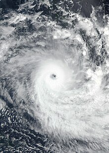
Cyclone Jasper approaching Queensland on 12 December.
During 6 December, warnings were issued by the Solomon Islands Meteorological Service for parts of Rennell and Bellona Province in the Solomon Islands, after it became apparent that Jasper was moving towards the southernmost islands of New Georgia.[45] They warned that the system was expected to produce gale-force winds, rough seas, moderate to heavy swells of 2.5–4.5 metres (8.2–14.8 ft) and coastal flooding over the islands.[45] Ships across the country were to be suspended.[46] Operations at Solomon Airlines were suspended throughout 5 December.[47] In anticipation of the possibility of Jasper making landfall on the Queensland coast at tropical cyclone intensity, the Australian Bureau of Meteorology (BoM) issued a number of official warnings to the public in advance of the system's arrival. Upon weakening to Category 1 strength at 12:00 UTC on 11 December, several storm warnings and a cyclone watch were issued for coastal and inland areas between Cooktown and Townsville.[48]
In preparation for Jasper, the Queensland police sent several people to help local councils.[49] In the city of Cairns, all flights for 13 December were postponed.[50] Evacuation centers were also set up in Cairns, Port Douglas, and Cooktown in preparation for the storm.[51] Services Australia temporarily closed some of its Medicare and Centrelink offices in Far North Queensland.[52] Meteorology staff on Willis Island, about 450 kilometres (280 mi) from the coast were evacuated by the Royal Australian Navy (RAN) before the cyclone passed through the area on 11 December.[53] Tourists towns prepared for flooding as they were in the firing line of the cyclone, while homeless people were offered shelter through local charities before Jasper arrived. Additionally, the mayor of Douglas Shire, Michael Kerr, urged tourists in the region to have a plan to bunker down during the cyclone.[54]
Impact and aftermath
Far North Queensland
Flooding at the Barron River Bridge in Kamerunga on 18 December
In Far North Queensland, Jasper caused thousands of properties to lose power.[55] Authorities rescued twelve people and a dog in Mossman who were stranded due to flooding.[56] Officials sent authorities to monitor areas affected by Jasper after looters raided homes and businesses.[57] The Queensland State Emergency Service (QSES) received 846 calls for help within Far North Queensland due to Jasper.[58] Numerous roads remained closed after the storm passed, including the Captain Cook Highway between Cairns and Port Douglas.[59] Jasper produced torrential rain throughout Northern Queensland, with five day totals of 2,166 mm (85.3 in) reported at Black Mountain and 2,025 mm (79.7 in) at Myola, both near the town of Kuranda, making Jasper the wettest tropical cyclone in Australia.[60][61] 24-hour totals include the Daintree catchment recording 624 mm (24.6 in) of rain, while the town of Diwan recorded exactly 500 mm (20 in).[62]
Cyclone Jasper also brought brief heavy rainfall accumulations in the Bloomfield River, averaging from 625–796 mm (24.6–31.3 in) with rainfall pushing 803 mm (31.6 in) in Wujal Wujal and Daintree Village.[63] The Barron River surpassed the March 1977 record of 3.8 metres (12 ft), making the event the worst flooding event since records began in 1915.[64] The water spilling over Copperlode Dam caused its catchment creek, Freshwater Creek, to break its banks, threatening the suburbs of Redlynch, Brinsmead and lower Freshwater.[65] The flooding was historic, breaking all records according to the BoM.[66] The BoM announced that 21 stations had received over 1,000 mm (39 in) since Jasper made landfall.[67] A man was found in a flooded home in Far North Queensland due to flooding caused by the cyclone.[68] An 85 year old male went missing due to the flooding in the town of Degarra.[69] Later damage assessments stated that 18 homes were destroyed, with another 168 severely damaged by the storm.[70]
The QSES responded to over 1,000 calls for help by people within the Cairns region.[71][72]Queensland Fire and Emergency Services swift water rescue crews and SES were also tasked with numerous requests for evacuations, within the coastal suburbs.[71] Many locals utilised personal watercraft to extract people who were trapped on their rooves within the coastal suburbs.[64] Cairns Airport also halted all operations, due to the low visibility and the extreme flooding occurring on the landing strip of the airport.[73] Insurance Council of Australia estimated that Jasper was responsible for AU$1 billion (US$675 million).[1] The Albanese government provided funding to residents who had been directly impacted by the event. A total of more than AU$15 million (US$10 million) was distributed to residents.[74] The National Australia Bank announced that AU$1.0 million (US$675,000) would be relief measures for customers that had been affected by the storm.[75] In January 2024, the Federal and Queensland governments jointly contributed AU$5 million (US$3.3 million) as a tourism recovery plan aimed at attracting travelers back to Far North Queensland.[76]
Cyclone Peter (1978) – a severe tropical cyclone which became the wettest tropical cyclone to impact Australia
Cyclone Katrina (1998) – an erratic severe tropical cyclone which also significantly weakened before reaching northern Queensland
Cyclone Tasha (2010) – a weak tropical cyclone that brought significant impacts to Queensland
Cyclone Yasi (2011) – a powerful and destructive severe tropical cyclone which also originated from the South Pacific Ocean before impacting Queensland
References
^ abNicholson, Dylan (31 December 2023). "Cyclone Jasper damage bill estimated to hit $1 billion". The Cairns Post. Archived from the original on 15 February 2024. Retrieved 2 January 2024.
^"Tropical Cyclone Jasper: December 2023". JBA Risk Management. Retrieved 25 January 2024.
^Tropical Disturbance Summary For area Equator to 25S, 160E to 120W issued from RSMC Nadi Dec 020627 UTC (Report). Fiji Meteorological Service. 2 December 2023. Archived from the original on 2 December 2023. Retrieved 2 December 2023.
^Tropical cyclone forecast 7 day forecast map (Report). Australian Bureau of Meteorology. 2 December 2023. Archived from the original on 2 December 2023.
^Significant Tropical Weather Advisory for the Western and South Pacific Oceans December 1, 2023 14:30z (Report). United States Joint Typhoon Warning Center. 1 December 2023. Archived from the original on 4 December 2023. Retrieved 1 December 2023.
^Tropical cyclone forecast 7 day forecast map (Report). Australian Bureau of Meteorology. 4 December 2023. Archived from the original on 4 December 2023.
^Tropical Disturbance Summary For area Equator to 25S, 160E to 120W issued from RSMC Nadi Dec 030740 UTC (Report). Fiji Meteorological Service. 4 December 2023. Archived from the original on 3 December 2023. Retrieved 4 December 2023.
^Tropical Cyclone Formation Alert (Invest 92P) (Report). United States Joint Typhoon Warning Center. 4 December 2023. Archived from the original on 4 December 2023. Retrieved 4 December 2023. Alt URL
^Bureau of Meteorology. Heavy rainfall and major flooding in Far North Queensland. Retrieved on 19 December 2023.
^ ab"Climate Education: Flood". Australian Bureau of Meteorology. Archived from the original on 17 March 2009. Retrieved 18 January 2011.
^"Tropical Cyclone Fletcher Impacts". Bureau of Meteorology. Government of Australia. 2014. Retrieved 5 March 2014.
^"Kowanyama, Queensland February 2014 Daily Weather Observations" (PDF). Bureau of Meteorology. Government of Australia. 2014. Archived from the original (PDF) on 6 March 2014. Retrieved 6 March 2014.
^"Report on Severe Tropical Cyclone Aivu: Rainfall" (PDF). Bureau of Meteorology. Government of Australia. 6 June 1990. p. 17–18. Retrieved 13 March 2014.
^"Tropical Cyclone May". Australian Bureau of Meteorology. 2013. Retrieved 29 January 2013.
^Queensland Tropical Cyclone Warning Centre (2014). "Tropical Cyclone Justin" (PDF). Australian Bureau of Meteorology. Retrieved 11 March 2014.
^"Tropical Cyclone Ellie". Australian Bureau of Meteorology. 2009. Retrieved 27 January 2013.
^Williams, Brian; Michael, Peter (24 January 2013). "Ex-cyclone Oswald heads south with heavy rain tipped for long weekend". The Courier Mail. Australian Associated Press. Archived from the original on 24 January 2013. Retrieved 24 January 2013.
^Prognostic Reasoning for Tropical Cyclone 03P (Three) Warning No. 1 (Report). United States Joint Typhoon Warning Center. 5 December 2023. Archived from the original on 5 December 2023. Retrieved 5 December 2023. Alt URL
^Eastern Region Tropical Cyclone Technical Bulletin issued at 0740 UTC 05/12/2023 (Report). Australian Bureau of Meteorology. 5 December 2023. Archived from the original on 5 December 2023. Retrieved 5 December 2023.
^Tropical Cyclone Technical Bulletin for Tropical Cyclone Jasper issued at 13:14 UTC on 5 December 2022 (Eastern Region) (Report). Australian Bureau of Meteorology. 18 December 2022. Archived from the original on 5 December 2023. Retrieved 5 December 2023.
^Prognostic Reasoning for Tropical Cyclone 03P (Jasper) Warning No. 5 (Report). United States Joint Typhoon Warning Center. 6 December 2023. Archived from the original on 6 December 2023. Retrieved 6 December 2023. Alt URL
^Eastern Region Tropical Cyclone Technical Bulletin issued at 0728 UTC 06/12/2023 (Report). Australian Bureau of Meteorology. 6 December 2023. Archived from the original on 6 December 2023. Retrieved 6 December 2023.
^Prognostic Reasoning for Tropical Cyclone 03P (Jasper) Warning No. 11 (Report). United States Joint Typhoon Warning Center. 7 December 2023. Archived from the original on 7 December 2023. Retrieved 7 December 2023. Alt URL
^Eastern Region Tropical Cyclone Technical Bulletin issued at 1911 UTC 07/12/2023 (Report). Australian Bureau of Meteorology. 7 December 2023. Archived from the original on 7 December 2023. Retrieved 7 December 2023.
^Prognostic Reasoning for Tropical Cyclone 03P (Jasper) Warning No. 13 (Report). United States Joint Typhoon Warning Center. 8 December 2023. Archived from the original on 8 December 2023. Retrieved 8 December 2023. Alt URL
^Eastern Region Tropical Cyclone Technical Bulletin issued at 0706 UTC 08/12/2023 (Report). Australian Bureau of Meteorology. 8 December 2023. Archived from the original on 8 December 2023. Retrieved 8 December 2023.
^Prognostic Reasoning for Tropical Cyclone 03P (Jasper) Warning No. 14 (Report). United States Joint Typhoon Warning Center. 8 December 2023. Archived from the original on 8 December 2023. Retrieved 8 December 2023. Alt URL
^Prognostic Reasoning for Tropical Cyclone 03P (Jasper) Warning No. 18 (Report). United States Joint Typhoon Warning Center. 9 December 2023. Archived from the original on 9 December 2023. Retrieved 9 December 2023.
^Eastern Region Tropical Cyclone Technical Bulletin issued at 0132 UTC 10/12/2023 (Report). Australian Bureau of Meteorology. 10 December 2023. Archived from the original on 10 December 2023. Retrieved 10 December 2023.
^Prognostic Reasoning for Tropical Cyclone 03P (Jasper) Warning No. 20 (Report). United States Joint Typhoon Warning Center. 9 December 2023. Archived from the original on 9 December 2023. Retrieved 9 December 2023.
^Eastern Region Tropical Cyclone Technical Bulletin issued at 0734 UTC 10/12/2023 (Report). Australian Bureau of Meteorology. 10 December 2023. Archived from the original on 10 December 2023. Retrieved 10 December 2023.
^Prognostic Reasoning for Tropical Cyclone 03P (Jasper) Warning No. 25 (Report). United States Joint Typhoon Warning Center. 11 December 2023. Archived from the original on 11 December 2023. Retrieved 11 December 2023.
^Prognostic Reasoning for Tropical Cyclone 03P (Jasper) Warning No. 24 (Report). United States Joint Typhoon Warning Center. 10 December 2023. Archived from the original on 10 December 2023. Retrieved 10 December 2023. Alt URL
^Eastern Region Tropical Cyclone Technical Bulletin issued at 1923 UTC 11/12/2023 (Report). Australian Bureau of Meteorology. 11 December 2023. Archived from the original on 11 December 2023. Retrieved 11 December 2023.
^Prognostic Reasoning for Tropical Cyclone 03P (Jasper) Warning No. 28 (Report). United States Joint Typhoon Warning Center. 11 December 2023. Archived from the original on 11 December 2023. Retrieved 11 December 2023. Alt URL
^Prognostic Reasoning for Tropical Cyclone 03P (Jasper) Warning No. 31 (Report). United States Joint Typhoon Warning Center. 12 December 2023. Archived from the original on 12 December 2023. Retrieved 12 December 2023. Alt URL
^Prognostic Reasoning for Tropical Cyclone 03P (Jasper) Warning No. 33 (Report). United States Joint Typhoon Warning Center. 13 December 2023. Archived from the original on 13 December 2023. Retrieved 13 December 2023. Alt URL
^Prognostic Reasoning for Tropical Cyclone 03P (Jasper) Warning No. 34 (Report). United States Joint Typhoon Warning Center. 13 December 2023. Archived from the original on 13 December 2023. Retrieved 13 December 2023. Alt URL
^Eastern Region Tropical Cyclone Technical Bulletin issued at 1214 UTC 13/11/2023 (Report). Australian Bureau of Meteorology. 13 December 2023. Archived from the original on 13 December 2023. Retrieved 13 December 2023.
^Tropical Cyclone 03P (Jasper) Warning No. 35 (Report). United States Joint Typhoon Warning Center. 13 December 2023. Archived from the original on 13 December 2023. Retrieved 13 December 2023. Alt URL
^Tropical Cyclone Advice Number 38 issued at 11:59 pm EST on Wednesday 13 December 2023 (Report). Australian Bureau of Meteorology. 13 December 2023. Archived from the original on 13 December 2023. Retrieved 13 December 2023.
^Tropical Cyclone 7 Day Forecast issued at 08:38 am UTC 15 December 2023 (Report). Australian Bureau of Meteorology. 15 December 2023. Archived from the original on 15 December 2023. Retrieved 15 December 2023.
^Tropical Cyclone 7 Day Forecast issued at 08:35 am UTC 18 December 2023 (Report). Australian Bureau of Meteorology. 18 December 2023. Archived from the original on 18 December 2023. Retrieved 19 December 2023.
^ abTropical Cyclone Warning Number 2 December 6, 2023 01:30 AM (Report). Solomon Islands Meteorological Service. 2 April 2020. Archived from the original on 5 December 2023. Retrieved 16 April 2020.{{cite report}}: CS1 maint: bot: original URL status unknown (link)
^"Ships cancel trips due to bad weather". Solomon Star News. 7 December 2023. Archived from the original on 13 December 2023. Retrieved 15 December 2023.
^"Tropical cyclone Jasper impacts Solomon Islands as it slowly moves away". RNZ. 8 December 2023. Archived from the original on 8 December 2023. Retrieved 15 December 2023.
^Tropical Cyclone Advice Number 4 issued at 10:46 am EST on Monday 11 December 2023 (Report). Australian Bureau of Meteorology. 11 December 2023. Archived from the original on 11 December 2023. Retrieved 11 December 2023.
^Touma, Rafqa (11 December 2023). "'Stay safe': Bureau of Meteorology staff evacuated and businesses close as Queensland braces for cyclone". The Guardian. Archived from the original on 11 December 2023. Retrieved 12 December 2023.
^"Tropical Cyclone Jasper moves towards Australia". Newshub. Reuters. 12 December 2023. Archived from the original on 13 December 2023. Retrieved 12 December 2023.
^"Far North Queensland makes final preparations for Tropical Cyclone Jasper as Cairns authorities tell residents to prepare to leave". Seven News. 12 December 2023. Archived from the original on 13 December 2023. Retrieved 13 December 2023.
^"Services Australia responds to impacts of Cyclone Jasper". Ministers in the Department of Social Services. 12 December 2023. Archived from the original on 3 January 2024. Retrieved 13 December 2023.
^"Willis Island's BOM weather station evacuated as Cyclone Jasper approaches Queensland - ABC News". amp.abc.net.au. Archived from the original on 14 December 2023. Retrieved 15 December 2023.
^"Far North Queensland 'like a movie scene' ahead of Cyclone Jasper's arrival". ABC News. 12 December 2023. Archived from the original on 14 December 2023. Retrieved 14 December 2023.
^McGuiness, Anna (13 December 2023). "Far North Queensland braces for Tropical Cyclone Jasper landfall". The Canberra Times. Archived from the original on 13 December 2023. Retrieved 13 December 2023.
^"Ex-Cyclone Jasper saw 12 people and dog rescued in north Queensland amid metre-deep floodwaters". The Guardian. 13 December 2023. Archived from the original on 3 January 2024. Retrieved 13 December 2023.
^"Police increase patrols in cyclone-affected areas after thefts and vandalism". www.9news.com.au. 14 December 2023. Archived from the original on 14 December 2023. Retrieved 14 December 2023.
^"Residents begin to assess damage from ex-Cyclone Jasper as heavy rain and flood threat persist — as it happened". ABC News. 13 December 2023. Archived from the original on 15 December 2023. Retrieved 16 December 2023.
^"Ex-Cyclone Jasper: Residents in far north Queensland brace for more rain as flooding cuts off towns". The Guardian. Australian Associated Press. 15 December 2023. ISSN 0261-3077. Archived from the original on 16 December 2023. Retrieved 16 December 2023.
^"Tropical Climate Update". 20 December 2023. Archived from the original on 20 December 2023. Retrieved 18 January 2024.
^Bureau of Meteorology. Two Qld locations register Australia's 3rd and 4th wettest day on record, provisional data shows. Retrieved on 18 December 2023.
^"Tropical Cyclone Jasper: flying mangoes and an almighty downpour but north Queensland residents remain unfazed". The Guardian. 14 December 2023. Archived from the original on 14 December 2023. Retrieved 14 December 2023.
^"Far North weather: Cyclone Jasper BOM update and emergency advice for Cairns, Port Douglas". The Cairns Post. 14 December 2023. Archived from the original on 13 December 2023. Retrieved 16 December 2023.
^ abJacques, Owen; Whiteman, Hilary; Staff (17 December 2023). "Cairns cut off with 'worst flood on record' as mayors call for help from Australian Defence Force". ABC News. Australian Broadcasting Corporation. Archived from the original on 16 December 2023. Retrieved 25 December 2023. (updated 18 Dec 2023)
^Council, Cairns Regional (17 December 2023). "Prepare to leave - Redlynch, Brinsmead, Lower Freshwater and Kamerunga". Cairns Regional Council. Archived from the original on 17 December 2023. Retrieved 17 December 2023.
^"Live: BOM forecasts rainfall until Tuesday as Far North Queensland flood risk remains high". ABC News. 16 December 2023. Archived from the original on 17 December 2023. Retrieved 17 December 2023.
^"Emergency flood alerts issued for parts of Far North Queensland in the wake of ex-Tropical Cyclone Jasper". ABC News. 16 December 2023. Archived from the original on 17 December 2023. Retrieved 17 December 2023.{{cite news}}: CS1 maint: bot: original URL status unknown (link)
^Jeffries, Sian; McCarthy, Isaac; Roberts, Jami; Achenza, Madeleine (18 December 2023). "Person confirmed dead after flood disaster". The Cairns Post. Archived from the original on 15 February 2024. Retrieved 3 January 2024.
^"Search and rescue for missing man, Degarra". Mirage News. Archived from the original on 3 January 2024. Retrieved 19 December 2023.
^"Flooding response update: 18 homes destroyed according to latest damage assessment". The Cairns Post.
^ abNewton, Matthew; McCarthy, Isaac (18 December 2023). "Far North Qld floods: Raw sewage leaking onto Cairns' streets as water supply restarted, Airport ready for flight". The Cairns Post. Archived from the original on 3 January 2024. Retrieved 18 December 2023.
^Cassidy, Caitlin; Wind, Emily; Wind (earlier), Emily (18 December 2023). "December rainfall records smashed – as it happened". the Guardian. ISSN 0261-3077. Archived from the original on 17 December 2023. Retrieved 18 December 2023.
^McLeod, Catie; Wind, Emily (17 December 2023). "Cairns airport closed as Queensland premier declares 'serious weather emergency' amid record flood fears". The Guardian. ISSN 0261-3077. Archived from the original on 17 December 2023. Retrieved 17 December 2023.
^"Australian Govt Pays $15M Disaster Aid for Cyclone Jasper Victims". Mirage News. Archived from the original on 3 January 2024. Retrieved 3 January 2024.
^"Banks offer support after Cyclone Jasper". www.mpamag.com. Archived from the original on 3 January 2024. Retrieved 3 January 2024.
^McLaughlin, Andrew. "Tourism support package announced for Far North Queensland in wake of Cyclone Jasper". PS News. Retrieved 5 January 2024.
External links
Wikimedia Commons has media related to Cyclone Jasper (2023).
Australian Bureau of Meteorology
Joint Typhoon Warning Center
Tropical Cyclone Warning Center Jakarta (in Indonesian)


 Extratropical cyclone, remnant low, tropical disturbance, or monsoon depression


