Balgoij
Village in Gelderland, Netherlands
51°46′49″N 5°42′50″E / 51.78028°N 5.71389°E / 51.78028; 5.71389 (2021)[1]
6613[1]
Balgoij or Balgoy is a village in Gelderland, Netherlands, near the river Meuse. It belongs to the Wijchen municipality.
Until 1923, Balgoij was a separate municipality. In 1958, the hamlet of Keent [nl] was transferred to Oss in North Brabant due to the canalisation of the Maas.[3]
The village was first mentioned in 1172 as Balgoie, and means swelling of land near water.[4] In 1840, it was home to 406 people.[3]
Gallery
-
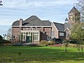
 Church in Balgoij
 -
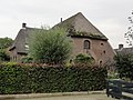
 Former clergy house
 -
 Villa in Balgoij


References
- ^ a b c "Kerncijfers wijken en buurten 2021". Central Bureau of Statistics. Retrieved 26 March 2022.
- ^ "Postcodetool for 6613AA". Actueel Hoogtebestand Nederland (in Dutch). Het Waterschapshuis. Retrieved 26 March 2022.
- ^ a b "Balgoij". Plaatsengids (in Dutch). Retrieved 26 March 2022.
- ^ "Balgoij - (geografische naam)". Etymologiebank (in Dutch). Retrieved 26 March 2022.
Wikimedia Commons has media related to Balgoy.
 | This Gelderland location article is a stub. You can help Wikipedia by expanding it. |
- v
- t
- e


