Bütow
Municipality in Mecklenburg-Vorpommern, Germany
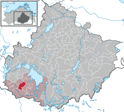
Location of Bütow within Mecklenburgische Seenplatte district
53°21′N 12°29′E / 53.350°N 12.483°E / 53.350; 12.483
(2022-12-31)[1]
17209
Bütow is a municipality in the Mecklenburgische Seenplatte district, in Mecklenburg-Vorpommern, Germany.
Geography
Bütow is located in the Mecklenburg Lake Plateau, to the east of the source of the Elde river. It is a hilly area, with the highest point 101 m (331 ft) above sea level.
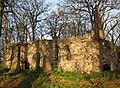
- Church ruin in Bütow-Dambeck
-

-
 Nave
Nave -
 Choir
Choir -
 Gable
Gable -
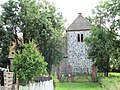 Village church in Bütow.


Transportation
Bütow is located about two kilometers away from the federal highway B 198. The Autobahn 19 Berlin - Rostock is about three kilometers away. The nearest railway station is located in Malchow.
References
- ^ "Bevölkerungsstand der Kreise, Ämter und Gemeinden 2022" (XLS) (in German). Statistisches Amt Mecklenburg-Vorpommern. 2023.
External links
![]() Media related to Bütow at Wikimedia Commons
Media related to Bütow at Wikimedia Commons
- Gutshaus Bütow
- v
- t
- e
Towns and municipalities in Mecklenburgische Seenplatte
- Altenhagen
- Altenhof
- Altentreptow
- Alt Schwerin
- Ankershagen
- Bartow
- Basedow
- Beggerow
- Beseritz
- Blankenhof
- Blankensee
- Blumenholz
- Bollewick
- Borrentin
- Bredenfelde
- Breesen
- Breest
- Briggow
- Brunn
- Buchholz
- Burg Stargard
- Burow
- Bütow
- Carpin
- Cölpin
- Dargun
- Datzetal
- Demmin
- Eldetal
- Faulenrost
- Feldberger Seenlandschaft
- Fincken
- Friedland
- Fünfseen
- Galenbeck
- Gielow
- Gnevkow
- Godendorf
- Göhren-Lebbin
- Golchen
- Gotthun
- Grabowhöfe
- Grammentin
- Grapzow
- Grischow
- Groß Kelle
- Groß Miltzow
- Groß Nemerow
- Groß Plasten
- Groß Teetzleben
- Grünow
- Gültz
- Gülzow
- Hohenbollentin
- Hohenmocker
- Hohen Wangelin
- Hohenzieritz
- Holldorf
- Ivenack
- Jabel
- Jürgenstorf
- Kargow
- Kentzlin
- Kieve
- Kittendorf
- Klein Vielen
- Kletzin
- Klink
- Klocksin
- Knorrendorf
- Kratzeburg
- Kriesow
- Kublank
- Kuckssee
- Kummerow
- Lärz
- Leizen
- Lindenberg
- Lindetal
- Malchin
- Malchow
- Meesiger
- Melz
- Mirow
- Möllenbeck
- Möllenhagen
- Mölln
- Moltzow
- Neddemin
- Neetzka
- Neubrandenburg
- Neuenkirchen
- Neukalen
- Neustrelitz
- Neverin
- Nossendorf
- Nossentiner Hütte
- Penzlin
- Peenehagen
- Pragsdorf
- Priborn
- Priepert
- Pripsleben
- Rechlin
- Ritzerow
- Röbel
- Röckwitz
- Rosenow
- Sarow
- Schloen-Dratow
- Schönbeck
- Schönfeld
- Schönhausen
- Schwarz
- Siedenbollentin
- Siedenbrünzow
- Sietow
- Silz
- Sommersdorf
- Sponholz
- Staven
- Stavenhagen
- Stuer
- Südmüritz
- Torgelow am See
- Trollenhagen
- Tützpatz
- Userin
- Utzedel
- Verchen
- Voigtsdorf
- Vollrathsruhe
- Walow
- Waren (Müritz)
- Warrenzin
- Werder
- Wesenberg
- Wildberg
- Woggersin
- Wokuhl-Dabelow
- Wolde
- Woldegk
- Wulkenzin
- Wustrow
- Zettemin
- Zirzow
- Zislow

Authority control databases | |
|---|---|
| International |
|
| Geographic |
|
 | This Mecklenburgische Seenplatte (district) location article is a stub. You can help Wikipedia by expanding it. |
- v
- t
- e


