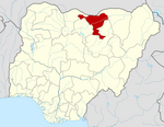
Auyo
LGA and town in Jigawa State, Nigeria
12°21′36″N 9°59′8″E / 12.36000°N 9.98556°E / 12.36000; 9.98556 Nigeria
 (2006)

Auyo is a Local Government Area of Jigawa State, Nigeria. Its headquarters are in the town of Auyo.
It has an area of 512 km2 and a population of 132,001 at the 2006 census.
The postal code of the area is 731.[1]
The Auyokawa language, now extinct, was formerly spoken in Auyo.[2]
And its Also has ten (10) political words which include:
Auyo, Auyokayi, Ayama, Ayan, Gatafa, Gamafoi, Gamsarka, Kafur, Tsidir, and Unik.
Gallery
-

-
 Auyo Town
 -
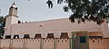 Central Mosque Auyo
 -

-

-


References
- v
- t
- e
Jigawa StateState capital: Dutse
- Auyo
- Babura
- Biriniwa
- Birnin Kudu
- Buji
- Dutse
- Gagarawa
- Garki
- Gumel
- Guri
- Gwaram
- Gwiwa
- Hadejia
- Jahun
- Kafin Hausa
- Kazaure
- Kiri Kasama
- Kiyawa
- Kaugama
- Maigatari
- Malam Madori
- Miga
- Ringim
- Roni
- Sule Tankarkar
- Taura
- Yankwashi
 | This Jigawa State, Nigeria location article is a stub. You can help Wikipedia by expanding it. |
- v
- t
- e


