Annfield Plain railway station
Disused railway station in County Durham, England
Annfield Plain | |
|---|---|
 | |
| General information | |
| Location | Annfield Plain, County Durham England |
| Grid reference | NZ169512 |
| Platforms | 2 |
| Other information | |
| Status | Disused |
| History | |
| Original company | North Eastern Railway |
| Pre-grouping | North Eastern Railway |
| Post-grouping | London and North Eastern Railway |
| Key dates | |
| 1 February 1894 | Station opens |
| 23 May 1955 | Station closes |
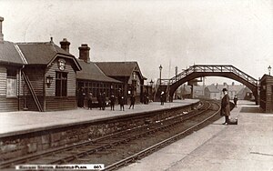
Annfield Plain railway station was in County Durham in Northern England, on the original south section of the industrial Stanhope and Tyne Railway, which diverged from the East Coast Main Line south of Newcastle.
History
The station was opened by the North Eastern Railway, and it became part of the London and North Eastern Railway during the Grouping of 1923. The station then passed on to the Eastern Region of British Railways on nationalisation in 1948.
The station was closed by British Railways on 23 May 1955.
| Preceding station | Disused railways | Following station | ||
|---|---|---|---|---|
| Leadgate Line and station closed | London and North Eastern Railway North Eastern Railway | West Stanley Line and station closed |
The site today
The station has since been demolished and replaced by a supermarket. Nothing remains of the station.
References
Notes
Sources
- Butt, R. V. J. (October 1995). The Directory of Railway Stations: details every public and private passenger station, halt, platform and stopping place, past and present (1st ed.). Sparkford: Patrick Stephens Ltd. ISBN 978-1-85260-508-7. OCLC 60251199. OL 11956311M.
- Jowett, Alan (March 1989). Jowett's Railway Atlas of Great Britain and Ireland: From Pre-Grouping to the Present Day (1st ed.). Sparkford: Patrick Stephens Ltd. ISBN 978-1-85260-086-0. OCLC 22311137.
- Jowett, Alan (2000). Jowett's Nationalised Railway Atlas (1st ed.). Penryn, Cornwall: Atlantic Transport Publishers. ISBN 978-0-906899-99-1. OCLC 228266687.
- Station on navigable O.S. map
54°51′22″N 1°44′13″W / 54.856°N 1.737°W / 54.856; -1.737
- v
- t
- e
Closed railway stations in County Durham
- Lintz Green
- High Westwood
- Ebchester
- Shotley Bridge
- Blackhill
- Consett (DVR)
NER Annfield and Beamish Deviations
- Burnhill
- Rowley
- Hownes Gill
- Consett
- Carr House
- Leadgate
- Pelton (S&T)
- Durham Turnpike
Annfield Plain- West Stanley
- Beamish
- Pelton
NER Elvet Branch
- Seaton (County Durham)
- Murton
- South Hetton
- Haswell (D&S)
- Hetton
- Rainton
- Pittington
- Sherburn House
- Shincliffe Town
Durham Elvet
- Fencehouses
- Leamside
- Frankland
- Belmont (Durham)
- Durham (Gilesgate)
- Sherburn Colliery
- Shincliffe
- Crawley (Northumberland)
- Waskerley
- Saltersgate Cottage
- High Stoop
- Tow Law
and Hartlepool Junction Railway
- West Cornforth
- Coxhoe Bridge
- Trimdon
- Wingate
- Ushaw Moor
- Waterhouses (County Durham)
- Brandon Colliery
- Brancepeth
- Willington (County Durham)
- Hunwick
- Seaham Hall Dene
- Seaham Harbour
- Hawthorn Tower Halt
- Easington
- Horden (first)
- Blackhall Colliery
- Blackhall Rocks
Stockton and Hartlepool Railway
- Haswell
- Shotton Bridge
- Thornley
- Wellfield
- Castle Eden
- Hesleden
- Hart
- Hartlepool (HD&R)
Greatham
Simpasture Branch
Port Clarence Branch
Byers Green Branch and NER Extension
- Coxhoe (WHHR)
- Ferryhill
- Sedgefield
- Stillington
- Redmarshall
- Norton Junction
- Stockton (Clarence)
Simpasture- Demons Bridge
Norton-on-Tees- Billingham-on-Tees
- Belasis Lane
- Haverton Hill
- Port Clarence
Coundon- Byers Green
- Spennymoor
- Wellfield
- Hurworth Burn
- Wynyard (County Durham)
- Thorpe Thewles
Stockton and Darlington Railway
- Bowes
- Hulands
- Lartington
- Barnard Castle
- Cockfield Fell
- Haggerleases
- Lands
- Evenwood
- West Auckland
Fighting Cocks- Yarm Depots
- Stockton (S&D)
- Newport (S&D)
- Watson's Wharf
- Tanfield Lea
- Bowes Bridge
 | This article about a County Durham building or structure is a stub. You can help Wikipedia by expanding it. |
- v
- t
- e
 | This article on a railway station in North East England is a stub. You can help Wikipedia by expanding it. |
- v
- t
- e


