Al Jumail
Abandoned town in Al Shamal, Qatar
Al Jumail اَلْجُمَيْل | |
|---|---|
Abandoned town | |
 Aerial view of Al Jumail | |
| 26°05′59″N 51°09′40″E / 26.09972°N 51.16111°E / 26.09972; 51.16111[1] | |
| Country |  Qatar Qatar |
| Municipality | Al Shamal |
| Zone | Zone 78 |
| District no. | 395 |
| Area | |
| • Total | 2.3 sq mi (6.0 km2) |
Al Jumail (Arabic: اَلْجُمَيْل) is an abandoned village in north-east Qatar located in the municipality of Al Shamal.[3][4] It was an important town in the northern peninsula prior to the 21st century.
Nearby settlements include Ruwayda to the south-west and Yusufiyah and Abu Dhalouf to the north.
Etymology
The town's name comes from the Arabic word "jameel", which means "beautiful"; a reference to the trees that grow in the area year-round.[4]
Various alternative transliterations of the name are used, such as Al Jemail, Al Jamil,[1] Lumail,[5] and Yamail.[6]
History
In the 1820s, George Barnes Brucks was tasked with preparing the first British survey of the Persian Gulf.[7] He documented Al Jumail in this survey, referring to it as "Yamale" and concisely stating that "Yamale, in lat. 26° 5' 40" N., long. 51° 14' E., is a small village."[8]
In J.G. Lorimer's Gazetteer of the Persian Gulf written in the early 1900s, he makes mention of Jumail, noting its location as "midway between Abu Dhalouf and Khor Hassan", and states that it is also called Yamail or Lumail. He goes on to state that there are remains of houses and a fort.[9]
Gallery
-
 Ruined houses in Al Jumail.
 -
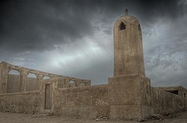 Al Hussein Mosque in Al Jumail overlooked by dark clouds.
 -
 The area around Al Hussein Mosque.


References
- ^ a b "Al-Jamil: Qatar". geographic.org. Retrieved 19 January 2019.
- ^ "District Area Map". Ministry of Development Planning and Statistics. Retrieved 20 May 2019.
- ^ "Qatar Development Atlas - Part 1" (PDF). Ministry of Development Planning and Statistics. 2010. p. 10. Archived from the original (PDF) on 18 July 2020. Retrieved 19 January 2019.
- ^ a b "Geoportal". The Centre for Geographic Information Systems of Qatar. Archived from the original on 24 November 2020. Retrieved 18 January 2019.
- ^ "Lumail: Qatar". geographic.org. Retrieved 28 February 2019.
- ^ "Yamail: Qatar". geographic.org. Retrieved 28 February 2019.
- ^ Mark Hobbs. "George Barnes Brucks and the First English Survey of the Gulf". Qatar Digital Library. Retrieved 19 January 2019.
- ^ G.B. Brucks; Robert Hughes Thomas (1856). "Historical and other information connected with place in the Persian Gulf". Bombay Education Society's Press. p. 562. This article incorporates text from this source, which is in the public domain.
- ^ "'Gazetteer of Arabia Vol. II' [1497] (570/688)". Qatar Digital Library. Retrieved 2 June 2024.
- v
- t
- e
 Al Shamal Municipality
Capital: Madinat ash Shamal
| Census-designated districts | |
|---|---|
| Other districts |
|
| Census-designated districts | |
|---|---|
| Other districts |
|
| Census-designated districts | |
|---|---|
| Other districts |
|
 Category:Al Shamal
 | This Qatari location article is a stub. You can help Wikipedia by expanding it. |
- v
- t
- e


