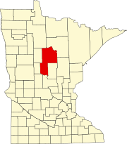
Ah-gwah-ching, Minnesota
Unincorporated community in Minnesota, US
Unincorporated community in Minnesota, United States
47°04′27″N 94°33′46″W / 47.07417°N 94.56278°W / 47.07417; -94.5627856430
Ah-gwah-ching is an unincorporated community in Shingobee Township, Cass County, Minnesota, United States, near Walker.
It is located along State Highways 200 (MN 200) and 371 (MN 371), two miles south-southeast of Walker. Ah-gwah-ching has the ZIP code 56430.[2]
The name Ah-gwah-ching means "out-of-doors" in the Ojibwe language.
References
- ^ "Ah-gwah-ching, Minnesota". Geographic Names Information System. United States Geological Survey, United States Department of the Interior.
- ^ ZIP Code Lookup Archived August 5, 2012, at the Wayback Machine
- v
- t
- e
Municipalities and communities of Cass County, Minnesota, United States
County seat: Walker

- Ansel
- Barclay
- Becker
- Beulah
- Birch Lake
- Blind Lake
- Boy Lake
- Boy River
- Bull Moose
- Bungo
- Byron
- Crooked Lake
- Deerfield
- Fairview
- Gould
- Hiram
- Home Brook
- Inguadona
- Kego
- Leech Lake
- Lima
- Loon Lake
- Maple
- May
- McKinley
- Meadow Brook
- Moose Lake
- Otter Tail Peninsula
- Pike Bay
- Pine Lake
- Pine River
- Ponto Lake
- Poplar
- Powers
- Remer
- Rogers
- Salem
- Shingobee
- Slater
- Smoky Hollow
- Sylvan
- Thunder Lake
- Torrey
- Trelipe
- Turtle Lake
- Wabedo
- Walden
- Wilkinson
- Wilson
- Woodrow
territories
communities
reservation
‡This populated place also has portions in an adjacent county or counties
- Minnesota portal
- United States portal
This article about a location in Cass County, Minnesota is a stub. You can help Wikipedia by expanding it. |
- v
- t
- e


