Aïn Oussera
Place in Djelfa, Algeria
35°26′56″N 2°54′16″E / 35.44889°N 2.90444°E / 35.44889; 2.90444 Algeria
 (2005)
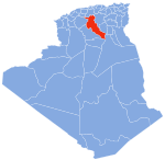
Aïn Oussera or Aïn Oussara (Arabic: عين وسارة) is a city in Djelfa Province, Algeria, with an estimated (2005) population of 134,174. It is the district seat of the Aïn Oussera District. This city, located 200 km south of the capital Algiers, is crossed by the Trans-Saharan Highway main road number 1. The road that runs through the whole of Algeria from north to south over 2000 km, connects Algiers on its southern border with Mali near Tamanrasset. Ain Oussera, has experienced, since 1990, rapid population growth due to its proximity to the 15 MW Es Salam nuclear reactor. Aïn Oussera is on the crossroads of the N1 (Trans-Saharan) and N40B highways. The nearest airport is the Algerian Air Force's Aïn Oussera airfield (DAAQ).
Geography
Climate
Aïn Oussera has a cold semi-arid climate (Köppen climate classification BSk), while it closely borders cold desert climate (BWk).
| Climate data for Ain Oussera | |||||||||||||
|---|---|---|---|---|---|---|---|---|---|---|---|---|---|
| Month | Jan | Feb | Mar | Apr | May | Jun | Jul | Aug | Sep | Oct | Nov | Dec | Year |
| Mean daily maximum °C (°F) | 13 (55) | 16 (60) | 18 (65) | 21 (69) | 26 (79) | 32 (90) | 37 (98) | 37 (99) | 31 (88) | 23 (73) | 17 (63) | 12 (54) | 23 (74) |
| Mean daily minimum °C (°F) | 1 (34) | 3 (37) | 6 (43) | 7 (44) | 11 (52) | 17 (62) | 19 (66) | 19 (67) | 16 (60) | 11 (51) | 6 (43) | 3 (38) | 10 (50) |
| Average precipitation mm (inches) | 15 (0.6) | 25 (1) | 33 (1.3) | 25 (1) | 15 (0.6) | 30 (1.2) | 0 (0) | 5.1 (0.2) | 36 (1.4) | 20 (0.8) | 15 (0.6) | 20 (0.8) | 240 (9.5) |
| Source: Weatherbase [1] | |||||||||||||
- v
- t
- e
Djelfa ProvinceCapital: Djelfa
- Aïn Chouhada
- Aïn El Ibel
- Aïn Feka
- Aïn Maabed
- Aïn Oussera
- Amourah
- Benhar
- Beni Yagoub
- Birine
- Bouira Lahdab
- Charef
- Dar Chioukh
- Deldoul
- Djelfa
- Douis
- El Guedid
- El Idrissia
- El Khemis
- Faidh El Botma
- Guernini
- Guettara
- Had-Sahary
- Hassi Bahbah
- Hassi El Euch
- Hassi Fedoul
- Messad
- Mouilha
- Mouadjebara
- Oum Laadham
- Sed Rahal
- Selmana
- Sidi Baizid
- Sidi Ladjel
- Tadmit
- Zaafrane
- Zaccar
References
 Algeria portal

- ^ "Weatherbase: Historical Weather for Ain Oussera, Algeria". Weatherbase. 2011. Retrieved on November 24, 2011.
Authority control databases | |
|---|---|
| International |
|
| National |
|
| Other |
|
 | This article about a location in Djelfa Province is a stub. You can help Wikipedia by expanding it. |
- v
- t
- e


