Đạ Tẻh district
You can help expand this article with text translated from the corresponding article in Vietnamese. (March 2009) Click [show] for important translation instructions.
- View a machine-translated version of the Vietnamese article.
- Machine translation, like DeepL or Google Translate, is a useful starting point for translations, but translators must revise errors as necessary and confirm that the translation is accurate, rather than simply copy-pasting machine-translated text into the English Wikipedia.
- Consider adding a topic to this template: there are already 952 articles in the main category, and specifying
|topic=will aid in categorization. - Do not translate text that appears unreliable or low-quality. If possible, verify the text with references provided in the foreign-language article.
- You must provide copyright attribution in the edit summary accompanying your translation by providing an interlanguage link to the source of your translation. A model attribution edit summary is
Content in this edit is translated from the existing Vietnamese Wikipedia article at [[:vi:Đạ Tẻh]]; see its history for attribution. - You may also add the template
{{Translated|vi|Đạ Tẻh}}to the talk page. - For more guidance, see Wikipedia:Translation.
District in Central Highlands, Vietnam
Đạ Tẻh district Huyện Đạ Tẻh | |
|---|---|
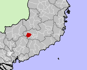 Location in Lâm Đồng province | |
| Country |  Vietnam Vietnam |
| Region | Central Highlands |
| Province | Lâm Đồng |
| Capital | Đạ Tẻh |
| Area | |
| • Total | 202 sq mi (524 km2) |
| Population (2003) | |
| • Total | 48,590 |
| Time zone | UTC+7 (Indochina Time) |
Đạ Tẻh is a rural district (huyện) of Lâm Đồng province in the Central Highlands region of Vietnam. As of 2003, the district had a population of 48,590.[1] The district covers an area of 524 km2. The district capital lies at Đạ Tẻh.[1]
References
- ^ a b "Districts of Vietnam". Statoids. Retrieved March 13, 2009.
- v
- t
- e
Districts of Vietnam Central Highlands
- Buôn Ma Thuột city※
- Buôn Hồ town
- Buôn Đôn
- Cư Kuin
- Cư M'gar
- Ea H'Leo
- Ea Kar
- Ea Súp
- Krông Ana
- Krông Bông
- Krông Búk
- Krông Năng
- Krông Pắc
- Lắk
- M'Drắk

※ denotes provincial seat.
11°33′46″N 107°32′00″E / 11.5628°N 107.5333°E / 11.5628; 107.5333
 | This article about a location in Lâm Đồng Province, Vietnam is a stub. You can help Wikipedia by expanding it. |
- v
- t
- e


